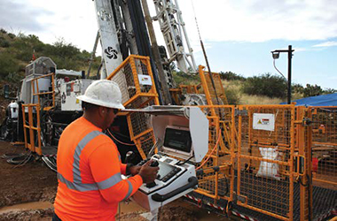
Able to drill down to 2,000 m, the LF 160i has electronic controls that allow semi-automated
drilling. (Photo: Boart Longyear)
Battery, Critical Minerals Demand
Prompts Innovation
Leading suppliers announce new solutions, locations and capabilities to support
miners riding the wave of demand for tomorrows resources
By Jesse Morton, Technical Writer
Autonomous Drill Rig
Improves Safety
Boart Longyear announced the LF160i drill
rig with autonomous capabilities, to include
the FREEDOM automated rod-handling
system. Previously, it released the new
Surface Roller Latch Wireline System.
The company said the solutions are the result of working closely with customers to ensure their exact needs are met. For Boart Longyear and exploration tooling, we are engaged with mine clients and drilling contractors to work with them on their primary focus areas, said Eric Humphrey, director of global products.
What weve heard from them is safety and productivity are the main areas they want to focus on and we want to bring solutions to them, he said. We want to open the doors and continue the communication with mining engineers and drilling contractors to make sure that they communicate to us their priorities and that we are focused on the needs that they have and continue to do so.
The LF160i, the next generation of the popular model, can drill down to 2,000 m, and features new autonomous and remote-control capabilities. The unit offers productivity and safety improvements over predecessor models. We are talking about intelligent controls, said María José Gálvez, global product manager, drills. In terms of safety, the electronic controls enable engineering to use programming rather than the hydraulic circuit, she said. We offer fully electronic controls that allow a semi-automated drilling routine such as control of some operational parameters, like rotation, bit rate, bit pressure, and water pump pressure. Autonomous and semi-autonomous operation improves uptime and productivity, Humphrey said.
The programmable controls and limits on the drill rig gives intelligence to the rig to not allow an operator to over-use or over-extend any of the critical controls or functions on the drill, which will help to avoid any downtime caused by drilling out of parameter or overexerting the drill rig in any of its cycles, he said.
Remote control and remote machine- monitoring capabilities can help improve safety for operators, Gálvez said. It allows for remote trouble shooting from anywhere, globally, to include routine updates and upgrades, she said. The rig can be paired with the FREEDOM Loader, which allows automated drilling, data loading, and 100% handsfree rod handling, Gálvez said. The solution is designed to achieve greater productivity and reduce human interaction with the drill.
Field results show the solution delivers safety improvements, Humphrey said. After making a technology change from the drills with hoist plugs to drills with FREEDOM Loader and Top Drive, customers have eliminated hand injuries on sites, and thats led to greater safety and productivity. FREEDOM uses rods with the new XQ thread type. The rods have double-start threads and a unique thread entry, said Chris Lambert, global product manager, exploration products. The two features combine to make it much easier to make and break. It doesnt cross-thread.
XQ simplifies the action involved in handling a rod. With the double-start threads that the XQ has, you dont have to go backwards and then forward. You can just go forward, Humphrey said. That capability really enables automation to a significant degree over the previous common thread types in the industry, Lambert said. Automation obviously is the key to getting peoples hands off of drill rods, he said. In addition, the improvements result in a rod thread that has the capability of lasting or going for twice as many make and breaks.
The new Surface Roller Latch Wireline System, announced in October, features new housing that reduces drop times by up to 60%. It has a new 360° swivel joint for easier handling, and a new release system that eliminates the jar staff, the supplier said. The system improvements continue with a redesigned head, improving core recovery times, Boart Longyear said. This is a surface wireline solution that incorporates dozens of refinements that eliminate spearheads and lifting dogs completely. The system uses an overshot, a device that retrieves the tooling and sample from the bottom of the hole, Lambert said. It eliminates spearheads. The roller latch design has fewer wear parts than does the predecessor link latch, which eliminates a failure mode, Humphrey said.
It also features a more secure secondary safety pin, Lambert said. The new system, as long as the pin is used, wont rely on maintenance to ensure that it functions correctly, he said. As long as you can pull it out of the hole, it doesnt depend on your quality of maintenance to ensure it is safe to move around the site. When the system is used with the new matching head, the significantly faster descent can represent anywhere from 6% to 10% improvement in core in the box, so direct productivity improvement in drilling operations, Lambert said. The supplier also reported that field results show Boart Longyear diamond bits, released in 2016, significantly improve rig productivity.
The bit designs are based on a patented process that chemically bonds the diamonds to the matrix powder, said Jon Peterson, global product manager, diamond products. With that, what weve seen is now you are going from 40% exposure of that diamond to 80% of exposure before that diamond loses its stability in the metal matrix, he said. What that leads to is the diamond has the ability to be twice as productive.
The design gives a faster penetration rate, and better flushing of the cuttings away from the face because now you have more space between the metal part of the bit and the rock face, Peterson said. You are clearing those cuttings out, he said. That makes it so that the matrix pattern is not wearing away so fast, improving life of bit.
Results from a Western Australia underground gold operation that switched from a competitor bit to our bit saw a 23% increase in meters drilled per hour, Peterson said. They were drilling through banded iron and quartz, he said. Thats huge. The longer were drilling in a hole, the more meters were drilling, the more money in the drillers pocket.
More money for the driller is one of the many goals the supplier strives to achieve, Humphrey said. We are here to make you more productive, he said. We also want our customers to continue reaching out to us, to let us know how our products are doing, to let us know what their needs are and where they need improvement.
MWD System Creates
Smart Rigs
Veracio announced full production of the
TruSub Drilling System, a new OEMagnostic,
bolt-on, measure-while-drilling
solution for diamond drill rigs.
It has been a decade in development,
with the last version having over 150,000
hours of field trials to really put it through
the works to make sure it is robust enough,
said CEO JT Clark. Were launching a topdrive
(diamond coring rig) version first with
a truck-drive version to come.
The main benefits offered stem from performance monitoring and orebody data collection. It is a great tool for enhancing driller productivity and providing real-time feedback on the performance on the rig and the drill string, Clark said. Perhaps foremost, it can detect whether the the drill is running or not, and if you are drilling or not, said Chief Innovation Officer Mike Ravella. That sounds basic, but right now in mining people dont actually know if the driller is drilling or not because they are likely out in the middle of a desert somewhere, by themselves, filling out a piece of paper that they control.
Beyond that, the data collected by TruSub can be used to reveal the performance of the rig and driller. You can start looking at when you are drilling if you are in this rock type with this bit, then why are you drilling fewer meters in a shift than this other person? Ravella said.
You can start looking at more detailed time management of the driller, as well as the behavior of the driller, he said. When they are drilling, when they are using the same bit in the same rock, why is it that one is penetrating the earth faster than the other and getting more meters in a shift?
Equally critically, the data collected can be used to determine rock properties. Because we have captured all of this data directly from the drill string, we can better start to understand the performance of the diamond bit as it turns through the ore or through the rock, Clark said. We can use that to directly measure rock properties, and well be looking to be making associations between the rock properties and the measured parameters.
The ability to gain rock property data earlier offers several downstream benefits. The biggest may be using that data to optimize crushing for better efficiency. There is critical data captured by Tru- Sub that is very likely tied to understanding how rocks will crush and the cost of doing so, Ravella said. The more you understand about the physical properties of ore, the geomechanical properties of the earth, the more efficient you can be at crushing rocks and approaching how you process ore.
The rock property data can also be used in mine planning. You drive efficiency in moving resources forward by defining orebodies faster, he said. If you combine TruSub with some of our other technologies, like the TruScan XRF sample scanning system, you can start understanding elemental concentrations of ore and mineralogy of ore, and start making estimates on if it is mineable ore that is going to be profitable or not. Otherwise, those estimates are not made until far later in the mining cycle, which can create a lot of costs for a client.
Early inquiries show TruSub will be deployed to both miners and contract drillers. Contractors are interested in obtaining data that can be used to support changes that lead to productivity gains. Driller productivity drives revenue, Clark said. For drillers who believe that they have a performance advantage, a productivity advantage in the field, this is an analytical tool that they can use to demonstrate their superior performance relative to their competitors.
Contractors can also use it as a training tool. For an inexperienced driller, to be able to learn and measure the data on how an experienced driller drills a hole and compare that to how they did on a similar hole, it allows you to actually analytically identify different drivers of performance, he said. Miners are interested in it for the same reasons, as well as to measure rock properties and collect data for use in daily reports. There are several different ways that they can simplify and automate some of the tasks or improve their intelligence about the orebody, Clark said.
TruSub traces its history back to a project at the Deep Exploration Technologies Collaborative Research Center (CRC) in Australia. The concept came from a request from drillers and mining houses on a piece of technology that they wish they had that wasnt available on the market, Clark said. The CRC developed that idea, he said. They took it to its first generation of a concept, and then we basically picked up that IP through our global tech subsidiary and have been developing it since then.
Separately, in December, Veracio announced International Directional Services (IDS) will offer its customers Veracios complete suite of solutions. By combining IDSs expertise in directional drilling and Veracios geological data collection, the partnership will empower IDS and Granite clients to reduce unnecessary drilling costs, mitigate operational errors, minimize waste, and foster sustainable mining practices, Veracio said.
The partnership stems from an extensive preexisting relationship that allowed IDS to fully trial and use Veracios solutions, Clark said. As we got to know the IDS team it was pretty clear that they had a desire for improved tooling to help guide them both in the technical services that they provide, like their directional drilling, as well as in their services offering, their wireline services, as well as the tools that they provide out to contract drillers, he said. What they really saw is an improved gyro, TruGyro.
Veracio describes TruGyro as the most compact and integrated continuous north-seeking gyro tool in drilling. What we are able to deliver is increased accuracy or improved accuracy relative to what is available on the market, Clark said.
IDS put our tools through the process, he said. They have a very high bar on the capabilities of the tools they provide to the market and the capabilities they work with, and they were really pleased that they saw the advantages, particularly in accuracy, that we can provide and, as a result, have adopted the tool suite both for themselves as well as for their customers.
Airborne Hydrogen Sniffer
Adds Flexibility
The U.S. Geological Survey (USGS)
contracted Xcalibur Smart Mapping for
aerial surveys of areas of Florida and
Alabama as part of the agencys Earth
Mapping Resources Initiative (MRI). The
surveys will image geology at the surface
and below ground using airborne
geophysical technology, with applications
to hurricane resiliency and critical mineral
resource evaluation, USGS said. The
data collected will be made freely available
to the public once complete.
The findings could be of interest to miners. Gamma ray spectrometry provides estimates of potassium, thorium, and uranium within the upper 1 to 2 ft of the ground, including beneath vegetation, said Anjana Shah, Ph.D. These data then tell us about the composition of rocks and sediments on the ground, the different sedimentary layers, she said. They can highlight areas with concentrations of heavy mineral sands, which are actively mined in northeastern Florida. They can tell us about the composition of phosphate-rich rocks.
The data will replace or supplement data collected several decades ago, and with a very coarse line spacing, Shah said. Collected before GPS positioning was available, some data were collected at 1.6-km line spacing, some at 10-km line spacing, she said. We are collecting data at 250-m line spacing. The funding for the project comes from the Bipartisan Infrastructure Law. That larger funding was a total of $320 million for five years, for $64 million a year, Shah said. This funding is supporting such data collection, as well as geologic mapping by state geological surveys, across the country.
XCalibur Smart Mapping has completed similar projects previously that resulted in a win for both government and miners, leadership at the supplier said. Xcalibur conducted a country-mapping program from 2015 to 2021 for Angola, said Michael Douglas, global country mapping manager. The results prompted big mining companies to begin a dialogue with the government. For the first time in 40 years, major mining companies such as Rio Tinto, Anglo American, and DeBeers entered the country.
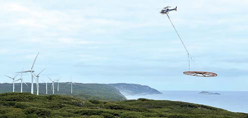
The supplier has also previously served mining companies. Xcaliburs HeliTEM system is a helicopter time-domain system that provides high-resolution conductivity imaging with maximum exploration depth and enhanced sensitivity to conductive targets, and it was key in a new greenfield PGE-Ni-Cu-Co sulphide discovery in the Julimar Complex in Western Australia, Douglas said. The Julimar Complex is located within an inferred 1,200- x 100-km Ni-Cu- PGE province, he said. It is a mafic-ultramafic layered intrusive complex, the structure of which has been delineated with high-resolution regional airborne magnetics in an area of poor exposure.
The helicopter survey was able to calibrate against the known high-grade PGE-Ni-Cu-Co sulphide zones identified from ongoing drilling at the Gonneville discovery site, successfully imaging the known mineralization, and outlining three new extensive electromagnetic anomalies within the Julimar State Forest: Hartog, Baudin and Jansz, Douglas said. Currently, Xcalibur is flying around 12 dedicated critical raw materials surveys, he said. These surveys are allowing the exploration companies to grade and fasttrack the most prolific deposits.
Miners are interested in the suppliers airborne survey offerings because in some circumstances they can help expedite an exploration program. In many cases, Xcalibur may be already operating in the region and can react quickly, acquiring the required data and delivering products within a matter of weeks, Douglas said. In the current climate, fast-tracking the exploration workflow and identifying potential critical raw materials deposits is paramount.
A helicopter or airplane survey can be an extremely quick way of acquiring high-resolution data, he said. A single month of acquisition can provide Geoscience teams with workable data and management teams with the knowledge to make strategic decisions. The case is different with land-based solutions where environmental concerns, land access and inhospitable terrain all hamper acquisition.
The Xcalibur Smart Mapping fleet spans more than 40 aircraft, each equipped with specialized instruments dedicated to identifying resources, Douglas said. The solutions deployed are varied and based on a combination of airborne geophysics and satellite remote sensing, he said. These include magnetometers, gamma-ray spectrometers, electromagnetic systems, or gravity gradiometers which measure, respectively, small variations to the Earths magnetic field, natural radioactivity, electric conductivity, and small variations to the gravity field, all caused by the distribution of different types of rocks and soils in the subsurface.
In 2024, the company will deploy a hydrogen sniffer, Douglas said. Mounted on an aircraft, the instrument quite literally smells the air for Hydrogen molecules! The range of technologies allows the supplier to offer options and flexibility. Flexibility is key, he said. Xcalibur can deliver data with pinpoint accuracy or design a survey to de-risk entire countries. The capability allows the supplier to serve as a one-stop shop for exploration, a strategic partner for countries and government for geothermal validation, water reservoirs, and land use, unlocking natural capital in every sense of the phrase, Douglas said.
XCaliber Smart Mapping launched in 2002 and quickly established itself as a proven performer on the global stage with key projects in Ghana and Nigeria in the early years, he said. CGG Airborne and Fugro were more recently added to the group, providing the capacity and technology spread to allow the company to become the global leader. The USGS is reportedly fielding inquiries from other U.S.-based suppliers interested in participating in the MRI.
New U.S. Op Offers Five
Airborne Services
In late 2023, New Resolution Geophysics
(NRG) opened an office in Portland,
Oregon, U.S.A., and will be offering five
services to the North American market.
The helicopter arrived in Oregon towards
the end of October, said Ryan
Louw, chief pilot and president of the U.S.
operation. Well be targeting government
and blue chip mining companies, which
we have traditionally been working for in
Australia, South Africa, Canada, and the
Middle East.
Time and costs savings are the top-listed benefits of NRG offerings. Rapid survey coverage, quick data acquisition, and quick turnaround time reduce the overall project timeline, Louw said. The company also uses new, stateof- the-art technology and proven techniques to get optimal resolution, he said. The services offered to the North American market include the companys flagship XCite offering, which basically uses a large-scale metal detector suspended from a helicopter, Louw said. We can map the conductivity of massive regions.
The Xcite system is comprised of an array of both electromagnetic and magnetic sensors attached to a 20-m-dia. inflatable ring or loop that hangs 30 m below the helicopter. The significant distance between the helicopter and the ring minimizes signal interference by the helicopter. Recent updates to the systems suspension resulted in a 2- to 10-fold decrease in noise levels, dependent on which base frequency is selected, company literature said.
Compared to similar competitor solutions, the magnetic sensors are suspended nearer to the surface, resulting in higher resolution data due to the saturation of targets, company literature said. The data allows for improved anomaly definition, improved special positioning, and reduced noise. The system can be tailored to the project needs, Louw said. Using the latest electromagnetic system available on the market, the system has exceptional signal- to-noise ratio, is capable of switching from 25 Hz to 12.5 Hz, has programmable waveform, a very fast channel time, he said. It has excellent depth investigation and has a very good performance in both the early and the late time channels.
It can also be rapidly deployed, set up and commissioned. Our system is very easy to ship, Louw said. Deflated, it can be folded up onto a 1-m2 pallet and can be shipped anywhere in the world and inflated, and commissioned in half a day. NRG USA is also offering Xplorer, Xact, Xtract and a new strapdown gravimeter survey system. The Xplorer magnetic and radiometric surveys offer a sampling rate of 20 Hz and 2 Hz, respectively. This, coupled with slower survey speed, results in a downline sample window of approximately 20 m which is a three-fold improvement on standard fixed-wing systems, company literature said.
The Xact fixed-wing magnetic and radiometric system uses the Pilatus PC-6 Turbo Porter STOL aircraft and state-of-the-art Radiation Solution Spectrometers with up to 2,048-in.3 Nal crystal packs for the highest standard currently available, NRG said. The Xtract gravity system uses a gravimeter with a custom-designed accelerometer mounted inside a gyro-stabilized unit, NRG said. Inputs from the gyros, inclinometers, angle sensors and dual-frequency GPS are used to drive servo motors, which maintain the sensor in a vertical position.
Xtract uses a Pilatus PC6 plane, which has an exceptionally low stall speed, resulting in the highest possible resolution of data, NRG said. The aircraft has an exceptional endurance with long-range tanks and is ideally suited for the large prospect areas typically covered in airborne gravity surveys. The new strapdown gravimeter system, released in 2021 is a laser ring gyro that can be incorporated with any of our existing technologies, Louw said.
NRG launched in 2005 and since then has collected more than 4 million line-kilometers of geophysical data across more than 50 countries, Louw said. Initially, we were focused on Africa and the Middle East and expanded to cover Australia in 2016, with our U.S. operations opening in 2023. At the Wonderboom Airport in South Africa, NRG maintains a fleet of eight helicopters and three planes.
The move to open a location in the U.S. was inspired in part by trending demand for battery metals and critical minerals, he said. There is definitely a lot of need for our services in North America.
AeroPhysX
An expert at AeroPhysX said dronebased
time domain or transient electromagnetic
(D-TDEM) surveys offer higher
resolution at a lower cost over traditional
exploration surveys.
It has a unique ability to produce
extremely high-resolution data on conductive/
resistive layering and mineral
deposit occurrences from near-surface
to hundreds of meters deep cost effectively,
said Trevor Grace, chief data
processor. It can penetrate deeper than
conventional methods and reveal potential
ore bodies at depth.
Drone based magnetometric resistivity (MMR) surveys can define nonmagnetic features such as quartz veins that contain gold and which are essentially invisible to other techniques, he said. Another is diamondiferous gravel pits and kimberlites for diamonds exploration. The D-TDEM surveys can also define variations in subsurface geology, mineralization, and groundwater with extremely high resolution, Grace said. Such precise insights boost investor confidence by presenting a comprehensive understanding of potential mining sites or for base-level and pollution monitoring purposes.
Such precise insights also set D-TDEM surveys apart from other methods and offerings. It is all about resolution, Grace said. The alternative techniques are highly costly and are designed more for larger areas and more regional type results, he said. We are able to fly very low and at line spacings down to 10 m apart. The D-TDEM MMR survey system uses a drone, a 1 kHz magnetometer, a magnetic or electric field transmitter, and flight software. It measures simultaneously, the slowly varying field strength of the earths magnetic field; and, in addition, superimposed on this magnetic field, is also the magnetic signature of the fast-changing manmade induced currents in the subsurface, company literature said.
The TDEM effect stems from the switch-off of the current flowing in a transmitter loop, which causes the magnetic field of the loop to collapse periodically, Grace said. This collapsing magnetic field induces current rings to flow in the subsurface, he said. The rings are recorded by our Geometrics MagArrow magnetometer because it can sample fast enough. In an electrically resistive medium the current rings and their associated magnetic fields decay rapidly. If there are conductive bodies in the subsurface of large enough proportions, current flow will linger in these bodies and these current rings and associated magnetic fields will decay slower and will contribute their own magnetic fields over a longer time to the magnetometer measurements, Grace said. Our magnetometer can measure very fast, thereby keeping track of the velocity and decay of the induced currents in the subsurface, he said. The magnetometer being extremely sensitive, measures in the Pico Tesla range and not the normal nanotesla.
In addition to cost savings, the offering can help a customer save time. By eliminating costly unproductive drilling through precise targeting of the correct areas to drill to confirm mineralization, D-TDEM accelerates project timelines, Grace said. Detailed subsurface information reduces uncertainty of not understanding the area of interest fully, instilling investor confidence, and advancing exploration programs swiftly, expediting the transition to mining phases.
A prototype D-TDEM system was first trialed roughly four years ago at the request of a potential customer. Aero- PhysX, in conjunction with Dr. Edgar Stetler, developed the technique and undertook a test survey over Flat Mine North, Nababeep, in Okiep in the Northern Cape of South Africa, Grace said.
The aim of the survey was to determine if the MagArrow magnetometer on the drone could detect the copper-bearing orebodies in the subsurface as either a solid or disseminated orebody in a highly resistive geology, he said. We mapped the existing ore and the dip of the orebody successfully as a medium conductor, but the surprise was that more conductive bodies existed roughly 200 m below the known ore-bodies, the composition of which still has to be determined.
More recently, Gamma-radiometry was integrated into our drone surveying capabilities with the addition of the Medusa gamma-ray spectrometer, allowing us to expand our capabilities significantly, Grace said. With this addition, were able to conduct UAV radiometric surveys concurrently or separately from magnetic surveys. The capability places us at the forefront of technological advancement in our field, he said. Our expertise in this specialized technique allows us to offer unique insights, delivering high-resolution data and unlocking hidden subsurface information with exceptional precision.
Drone Surveys Offer
More Control
GEM Systems said the companys aerial
drone-based sensors offer customers
more control, options and details than do
similar helicopter- or airplane-based survey
system solutions.
When deployed at lower altitudes, a
magnetometer or a VLF-electromagnetometer
will certainly give you more definition,
a lot more detail, said Michael Wilson, operations
manager, GEM Systems.
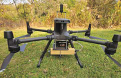
The companys potassium magnetometer is a lightweight, high-sensitivity magnetometer specifically designed for UAVs, GEM Systems said. Weighing less than 2.5 kg, the magnetometer can be used on many different UAV platforms with multi-rotor drones being the most common. The sensor is suspended from the drone. Youll put the electronics and the battery and any accessories right on the pad, on the bottom of the drone, and just hang the sensor, Wilson said. Currently, it is widely adopted as the DRONEmag and comes as a kit form the Matrice 300 (M300 DJI).
The magnetometer offers the highest sensitivity, absolute accuracy and gradient tolerance available in the industry, GEM Systems said. The sensors stream RS-232 or RS-485 data, which can be visualized for quality control purposes, if hardware is on board to facilitate a downlink of data. The potassium magnetometer is very high resolution, Wilson said. It has very low errors due to orientation, very high absolute accuracy, and very low noise, he said. It has a number of favorable characteristics for being able to do exploration work.
The GSMP-35U/25U magnetometer has 128 megabytes of edge storage, suitable for long flights, GEM Systems said. It offers high-quality data at the highest sampling rate of up to 20 readings per second. The magnetometer can be slung alone by a UAV or integrated into any UAV system such as our towed UAV AirBIRD and GradBIRD. One such system is the UAV VLF-EM (electromagnetic method), which uses distant, globally positioned transmitters that are broadcasting at frequencies in the range of 15 to 30 kHz, GEM Systems said. The system measures vertical deviations in a horizontal electromagnetic field generated by the transmitters. I dont think anyone else is offering that on a drone, Wilson said. The system captures the deviation as a percentage of total field, GEM Systems said. Many older systems only measure the total field and quadrature components of the field.
It uses two separate sensors with three lightweight orthogonal air coils in each to provide reduced noise and allow true in-phase and quadrature data to be gathered rapidly from two VLF transmitting stations simultaneously, regardless of sensor orientation, GEM Systems said. Data includes in-phase, out-ofphase, horizontal components in x and y, and field strength in picoTesla.
The system can be used with the potassium magnetometer in relatively close proximity to get both the magnetics and the electromagnetics, Wilson said. GEM Systems started in 1980 and initially sold a multi-sensor towed BIRD solution for helicopter-based surveys. The early BIRD solutions weighed up to 300 pounds. We started developing and getting into the UAVs probably about 2010, Wilson said. We just sort of miniaturized those BIRDs as much as we could without sacrificing performance.
Currently, the supplier produces turnkey solutions that can have the complete sensor package and all of the software and hardware that is required to get the raw data, he said. We definitely offer custom solutions based on the AirBIRD, GradBIRD, and DRONEmag. Purchases come with support on setting up and initial operation. We do offer some training, Wilson said. But principally speaking, operating a drone and system is relatively straightforward once you are set up.
Spectroscopy Captures
Critical Details
James Hutton Ltd. (JHL) advised using
X-ray Diffraction (XRD), scanning
electron microscopy (SEM), and Fourier-
transform infrared (FTIR) spectroscopy
in tandem to obtain optimal qualitative
and quantitative information on samples.
There are many ways in which FTIR,
XRD and SEM analysis are complementary
to each other, and a lot of additional
information can be gained when all three
techniques are used in combination with
each other, said Jean Robertson, head
of infrared spectroscopy, JHL.
Our team works together on an almost daily basis, integrating results to provide the best service for our clients, she said. Using XRD, SEM and FTIR together, we can provide a full technical overview of the product by combining compositional, quantitative, and morphological data. XRD is used for the characterization of minerals as each mineral has a different crystal structure and will produce a characteristic diffraction pattern when its crystal lattice interacts constructively with X-rays, said Dr. Ahmed Abd Elmola, research scientist, JHL. Furthermore, XRD can distinguish between different crystal stacking and polymorphs of the same mineral that result from different formation conditions, such as different pressures and temperatures.
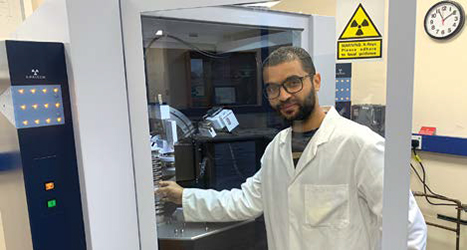
SEM and energy dispersive spectroscopy (EDS) can be used to explore morphology and elemental composition, respectively. With SEM, high-magnification images can be taken to investigate surface textures and form, said Laura-Jane Strachan, electron microscopy assistant, JHL. In addition, in-situ imaging of minerals provides structural information and interrelationships between mineral types.
Secondary electron detectors capture details of topography and surface textures, while the use of backscattered electron detectors allows for compositional differences to be highlighted for further investigation, she said. JHL has a deep history in mineral analysis, with particular expertise in working on kaolin minerals to visualize different kaolin types and morphologies, including kaolinite and halloysite, said Helen Pendlowski, X-ray powder diffraction mineralogist. We are also experienced in working on polyhalite. JHL also offers X-ray mapping, which allows material of known compositions to be located within larger structures.
FTIR spectroscopy captures the chemical profile or fingerprint of a sample, including both organic and inorganic components, Robertson said. The sampling technique we routinely use for FTIR analysis is attenuated total reflectance, which allows samples to be placed directly on a small sampling window and can be done on 1 mg of sample, or even less.
The sample time is short, typically within a couple minutes. For geological samples, the minerals present in the IR spectrum can be identified by a series of diagnostic bands characteristic of each mineral, Robertson said. Amorphous materials can be readily analyzed. FTIR can be used to capture detailed information about the nature of the minerals in a sample. For example, clay mineral substitutions can be detected by FTIR analysis, she said. We have done work on glauconites assessing the relative proportions of various cations present in different samples. FTIR can also be used to determine levels of order or disorder of minerals within samples. It can detect minerals, such as carbonates or kaolin minerals, at lower concentrations than can XRD.
Most FTIR analysis is done in the lab, but the company also uses a handheld FTIR spectrometer in the field. This can be extremely useful in exploration in identifying areas likely to contain a required mineral or metal deposit, Robertson said. JHL offers expertise in qualitative identification of minerals present in a sample, and expertise in developing quantitative calibration models to predict properties of samples by correlating measured parameters to spectral data, company literature said. These calibration models can be developed specifically to address an issue that a client has, it said; and, although some time is taken in the development stage, once developed it provides a rapid and reliable means for future analysis.
With labs and offices in Scotland, JHL is the commercial arm of the James Hutton Institute and traces its history back more than a half century. Our legacy Macaulay Institute was the pioneering lab for IR analysis of minerals worldwide, Robertson said. In addition to XRD, SEM and FTIR, a wide range of other analytical techniques are also available. Quality control is key to the work we do, with all methods accredited to ISO17025 standards, she said. We work with state-of-the-art instrumentation to provide a professional service to our clients.
Updated Software Supports
Collaboration, Efficiency
Seequent said the latest release of Oasis
montaj prioritizes efficiency and collaboration,
and features enhancements that
streamline processes. The new capabilities
help users preserve grid values, use
background gridding, and execute multigrid
2D filtering, said Rob Ferguson, segment
director, exploration and resource
management, Seequent.
Preserving grid values, meaning
adopting floating point GeoTIFF, ensuring
compatibility with industry standards
and optimizing cloud storage, he said.
The background gridding capability allows users to keep working while Oasis montaj grids in the background, Ferguson said. They can grid one dataset while cleaning another. Real-time updates give precise information on progress. The multi-grid 2D filtering capability allows users to streamline the workflow by selecting multiple input grids and applying filters with just a few clicks, he said. They can preview selected grids in the filter dialogue and auto-save grids in designated folders.
Separately, the company is developing new cloud capabilities for Seequent Evo. Its a solution that enables customers and the industry at large to collaborate and manage geoscience data in a single space, Ferguson said. It provides the foundation for connected workflows between Seequent and third-party applications. Guaranteeing such integration has long been a priority for Seequent, he said. It is clear that the easy targets in mining are gone, and viable discoveries are becoming ever more challenging to find, Ferguson said. Right now, data integration is the best way to get better results and find new targets or mines, he said. So, anything that slows down that integration, such as a bottleneck in the workflow where inversions cannot be completed quickly enough, is a risk to profitability. Integration is one of the primary benefits offered by Oasis montaj. For example, Leapfrog can read grid or voxel files from Oasis montaj, or vice versa, Ferguson said. Geological models from Leapfrog can, therefore, move into Oasis montaj without conversion, making the process simpler, faster and less prone to error, he said. Geophysicists can look at a Leapfrog project in Oasis montaj, and geologists can look at an Oasis montaj project in Leapfrog.
In Oasis montaj, users can import, overlay, and work with more than 50 common formats, from CAD to GIS, to mine planning and modelling, Ferguson said. Data is directly imported from online geoscience repositories, he said. They can code their processes through the Oasis montaj open API. Further, Oasis montaj has the capability to assimilate vast troves of that data. Users can view, transform, and analyze raw geology, geochemistry, and geophysics data with powerful 2D and 3D modelling capabilities, he said. The software rapidly assesses and experiments with large data sets in real time, running numerous filters and processes.
The software empowers users with tools to customize workflows. Users can record and automate repetitive and complex data-processing tasks, Ferguson said. They can streamline team workflows, save time, and add specific tools and workflows for the geoscience data needed with Oasis montaj extensions. More than 25 extensions are available, and can be used to visualize, process, and interpret specialized data, including ground and airborne or UAV surveys, magnetic and gravity, resistivity, radiometrics, geochemistry, and geology, he said.
By streamlining team workflows and offering other efficiency gains, Oasis montaj can help a miner meet critical deadlines. As a mining company matures, the volume and diversity of geophysics data grows, and the tasks become more complex, Ferguson said. Geophysics serves as an asset in amplifying the scope of mining and exploration projects that may help in accelerating revenue generation. Time savings can be gained from the creation of more insightful, integrated models at speed and on budget, he said. The software and its deliverables can be used to inform existing geological models with geophysics for sharper- focused insights.
It also enables those insights to be rapidly shared and assessed. Oasis montaj offers tools for visualizing, tracking, integrating and managing data from a centralized, auditable location, Ferguson said. On-demand modelling and cloud power accelerate discoveries and profitability. The system can also be used to help win and retain investors. It enables comprehensive visualization and analysis of geophysical and geological data, Ferguson said. With a clear and visually compelling representation of exploration findings, investors can better understand the potential of mining projects.