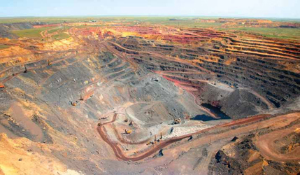
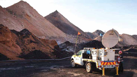
 The walls are coming down. The newest slope stability solutions offer greater integration, making them
easier to adopt
and deploy. Above, dewatering effects on highwall stability can be modelled in the new,
integrated GeoStudio Core.
(Photo: Seequent)
One obvious trend in the latest slope stability
solutions is improved integration.
The newest tech can now either easily integrate
or be integrated. Since integration
is a prerequisite for the digital mine, the
trend should, in theory, nudge more miners
in that direction.
Another quality the newer solutions
share is ease-of-use. Their operation is
described as intuitive, their interfaces as
friendly, and training as minimal.
Both trends suggest that, at least in
theory, future solutions will be easier and
less expensive to adopt. More mines will
be able to deploy more solutions that
immediately detect and, increasingly,
predict rock movement. Thus, most importantly,
they bode well for the future of
mine safety in general.
Integrated Solutions
Speed Alerts
Hexagon Mining and sister company IDS
GeoRadar announced upgrades to HxGN
MineProtect Collision Avoidance System
(CAS) and IBIS Guardian radar monitoring
software that allow the two to communicate
and drastically cut the time
between slope stability risk detection and
workforce awareness of it.
Guardians integration with CAS 4.6
means properly equipped office personnel,
equipment operators and mine site
pedestrians can receive near-real-time
equipment visualization and timely alerts
about hazardous areas and no-go zones.
The no-go zones are defined in Guardian,
which creates geofenced zones, hazard
maps and alarms. HxGN MineProtect
solutions, such as CASs in-cab display
and the wearable Personal Alert, deliver
the alarms and other specifications.
Hexagon Mining described the development
as an industry first. Others have
point-to-point or radio-based processes,
but cant really drive the information to
the whole fleet, Marcos Bayuelo, product
portfolio manager, MineProtect, Hexagon
Mining, said. Weve reduced the time to
communication to the minimum and really
ensured that the people that require
the information get it as fast as possible.
The upgrades to CAS and Guardian
launched in June 2020, and the field
testing that followed revealed some of the
capabilities offered through integration.
With the integrated solution, the process
of alerting a workforce to a slope stability
risk can involve only one person. IDS
GeoRadar slope monitoring radars detect
movement. That goes to Guardian, which
alerts the geotech crew. The geotech then
reviews and signs off on the alarms and
any no-go zone. That person drills down
to understand the alarm, and confirms it
and the no-go zone, Bayuelo said.
With only a click, and at the speed of
the mines network, the alarm and no-go
zone specs are distributed through CAS
and email. The no-go zone is in near-real-
time transmitted, he said.
So, now, all the vehicles and the vehicle
drivers can see be alerted instantly
about the incoming hazard, Bayuelo
said. Now they have the capability to
visualize where they should not go. And
if somebody gets in this zone, then the
supervisor or mine manager will see that
somebody is in the no-go zone.
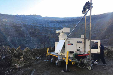 Recent updates allow Hexagons HxGN Collision Avoidance System and IDS GeoRadars
IBIS Guardian to communicate
directly for speedy slope stability alerts and the rapid
creation of geofenced no-go zones. Above, an IDS GeoRadar unit
scans a shadowy distant
slope. (Photo: Hexagon Mining)
Geotechs can set Guardian to monitor
certain areas more critically than it does
for others. You have different levels and
it is up to the mine as to what hazardous
area is transformed into a no-go zone, he
said. Within Guardian, you say, I want to
monitor here, here and here, because this
is a slope movement hazard. Once that
hazard reaches a level of criticality, then
the geotechs decide when this becomes a
no-go zone because the risk of collapse is
so high that nobody should be there.
IBIS Guardian now assimilates data
from, among other sources, the CAS server,
Francesco Coppi, production manager,
interferometric radars, IDS GeoRadar,
said. It can automatically import the
position of vehicles and working machineries and visualize them in real time on
the radar displacement maps, he said.
Highly accurate displacement data is
provided to monitoring specialists in
near-real time, as it happens, and using
an advanced automatic atmospheric correction
algorithm to avoid any mistake.
The primary benefit offered by the integration
is speed. What it does is it allows
you to really not require manual communication
between supervisors and the
control room, Bayuelo said. It enables
you to really create a workflow automatically
through the system integration.
Without the integration, you are living
in 2019, he said. Somebody in the
control room, or that is monitoring the
hazardous area, has to call somebody in
the mine that now needs to go somewhere
to block the area, which would transform
this process into a half hour or more.
Another benefit is awareness of who is
in or near the no-go zone. Which means
that nobody has to count, Bayuelo said.
Nobody has to be present, because technology
is the one that is present.
The biggest dividend is increased safety,
Neville Judd, communications director,
Hexagon Mining, said. It is important
because it is linking two ecosystems that
were previously unconnected, he said.
That separation potentially put people
at risk and now the two things are connected
and weve made that automatic,
Judd said. People
can now know, if
they are using the
system, that they
can depend on being
informed immediately
if they are
in danger, whereas
previously that
wasnt the case.
The development
should help prompt
customers who
have one of the two
software solutions
to upgrade it and
to adopt the other,
Bayuelo said. Upon
adoption, any training
required should be minimal and center
on workflow changes.
The new information that will be presented
to them will be intuitive enough
for them to understand it, Bayuelo said.
There is not a huge change management
or training regimen required.
The integration illustrates a couple
of the missions of Hexagon Mining and
parent company Hexagon AB. We are
now building solutions that can interact
with each other, talk to each other, make
decisions with each other, and enhance
the overall sum of our solutions, Bayuelo
said. We dont only offer the best solutions,
but the solutions themselves make
the business outcomes better, which is
the end goal of our company.
Platform Uses Most Sensors
GroundProbe reported seeing strong demand
for the MonitorIQ platform. The
suppliers chief operating officer, David
Noon, said because of its unique capabilities,
the aggregation software system is
destined to become the standard platform
for the majority of open-pit mines around
the world.
The platform can assimilate data from
more than 100 types of sensors, including
types made by competitors. It offers
the largest number of sensors you can incorporate
into a system, Noon said.
We have not locked out any data
source from this platform, he said. That
combined with robust processing analysis
creates a very data-rich environment
for customers to support confident decisions
on monitoring requirements.
 GroundProbes flagship slope monitoring platform, MonitorIQ, offers a one-screen view
of all the sensors, to include third-party sensors, in a mine, offering near-real-time
visibility
of all movements and deformations. (Photo: GroundProbe)
It will allow the mine to do some
pretty incredible things, including looking
more at the data science around what
each sensor provides and how it compares
with other sensors, he said.
The platform offers a single-dashboard
aggregation provides an overview of a
slope or tailings dam, the company said.
The development of MonitorIQ goes
back to 2004 when a customer reported
needing the ability to assimilate data from
multiple sources on a single platform. It
was a brilliant idea back then, but challenging
to implement, Noon said.
It probably hasnt been until the last
five years that this really has been able to be adopted because of expansion of IT in the
mining industry, he said. Now it can come
standard with GroundProbe equipment and
eventually will be installed across the entire
GroundProbe fleet for our customers.
The system has a number of features
that all but ensure widespread adoption.
It runs safety critical software complete
with a programmable alert system, and it
offers an intuitive interface that facilitates
reporting and supports efficient workflows.
MonitorIQ runs the companys SSR
Viewer software, which provides data
analysis capabilities to detect movement
and can be programmed to send alerts.
We have two types of notifications,
Noon said. There are the alerts built
into the GroundProbe monitoring systems
through what we call an alarm center.
They give a warning when movement is
detected by a GroundProbe system.
And then in the MonitorIQ platform,
with all of the third-party sensors, you can
set thresholds or triggers on data and on
trend analyses, thus predicting movement
and giving an early warning, he said.
The alarm center uses a watchdog
system to watch the software so if it is
not functioning correctly, the user gets an
alert, Noon said.
Designed to be easy and intuitive to
use, MonitorIQ offers a one-screen view
of all the sensors in a mine. If you want
to see all the movements or deformations
measured by all these different types
of sensors, whether they are point measurements
or line measurements or area
measurements from different types of
GroundProbe sensors, or even third-party
sensors, you get to see that all on a single
display and see how they all tell a similar
story, Noon said.
The capability helps streamline report
generation to vastly reduce the time involved.
They can design a standard template
and then draw in the data sources
into the template; and then, when they run
the report, it automatically updates the report
based on the live data from the MonitorIQ
software, Noon said. It is meant
to be a workflow process to make it much
simpler to get the data to a form that can
be easily understood by the operators.
The platform is designed to be a core
system in an integrated mine operation.
It is a platform that the industry has
been talking about for a long time, Noon
said. It is more than a product, he said.
It is building in an ongoing support for
the life of the mine, he added.
Recently, the supplier released a solution
that was developed with customer
input and meant to help miners move
toward increased digitization. SSR-Agilis
is a turnkey, rapid-deployment, vehicle-
mounted standalone monitoring system
that uses 3-D real aperture radar. It
is ideal for smaller operations that need a
highly mobile radar system, Noon said.
The customer asked to put a radar that
is typically on a trailer on a vehicle to be
able to move it in close and focus it exactly
on a work area, protecting the crew working
directly underneath a slope, Noon said.
SSR-Agilis measures submillimeter deformations,
and maintains that accuracy
even as range increases. It can sit anywhere
from 30 m to 1,400 m from the target.
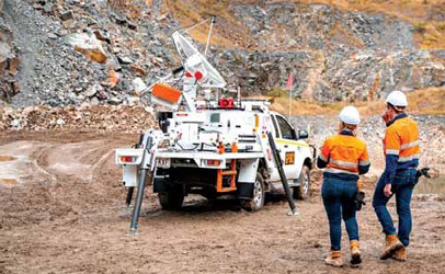 GroundProbes SSR-Agilis is mounted on a light vehicle for easy relocation, and can sit anywhere
from 30 m to 1,400
m from the target. It has an integrated camera, making it easier for users to
locate movement detected by radar.
(Photo: GroundProbe)
It is designed to be easy to use, and
to provide optimal visualization. The customer
is able to see the wall with a camera
image, but also with the radar data overlaid
on to it or co-registered with it. When
they see the heat map of the radar image
moving, they can, with their eyes, directly
identify the location on the slope that is
moving, Noon said. GroundProbe is the only technology that provides a co-registered
visual image and radar deformation
image to help to make a very quick intuitive
decision when safety is on the line.
One result is increased decision confi-
dence. From a users perspective, that is
the most valuable, he said.
The customer selects the model of
light vehicle, and GroundProbe takes it
from there. We deliver the vehicle of
their preference with the equipment installed
on it out to the site, Noon said.
The solution broadens the already
vast range of monitoring offerings from
GroundProbe. The technology that sits
on this platform is common across all
those platforms so all the software, all the
support and all the benefits that we have
are common across all the platforms.
SSR-Agilis, of course, can speak to
Monitor IQ. And both can be supported
by our area reps and remotely.
We are able to give solutions or solve
problems or do repairs or maintenance to
make sure the equipment is running with
as much uptime as possible, Noon said.
The miners really appreciate the local
and remote support, especially in this
time of COVID restrictions.
Modular Series Does
Double Duty
Reutech Mining reported the MSR Modular
series, known for versatility, offers
simultaneous critical and strategic monitoring
capabilities with submillimeter
precision, making it the most advanced
system of its kind on the planet.
The third-generation movement-andsurveying
radar system is designed to
operate in extreme conditions, and can
integrate with technologies from third parties,
such as Lecia GeoMos, Trimble 4D,
QuickSlope, SlideMinder and Rocscience.
 Reutech Minings MSR Modular series models can be truck-mounted, can integrate other sensors and
third-party
solutions, and can operate in extreme environments. Above, a unit scans for submillimeter
movement at Landau
coal mine in Mpumalanga, South Africa. (Photo: Reutech Mining)
MSR Modular offers multiple mounting
options, including trailer mounted, fixed
installation or vehicle mounted. The operating
temperature range runs from -50°C
to 55°C. Units are equipped with an integrated
onboard weather station with advanced
atmospheric correction algorithms.
Models within the series are licensed
for operating at as close as 30 m to as far
out as 4,000 m. They can operate off-level
by as much a 15°.
MSR Modular is known for its modularity,
Reutech Mining said. It provides
building blocks that consist of a radar
module, battery module, generator module and solar module, Jan de Beer, executive
manager, Reutech Mining, said.
This allows for custom solutions for
each requirement.
The MSR is also known for reliability
and accuracy. It offers operational availability
of more than 99%, de Beer said.
It can detect submillimeter movement
over long distances in harsh environments
and volatile atmospherics.
Units are capable of simultaneous strategic
and critical monitoring. A single
standalone system will alarm on movement
in critical areas while also doing wide-area
or strategic monitoring, de Beer said.
When powered by MSR Connect, the
series is the most cutting-edge geotechnical
monitoring solution available on the
market, he said. It is considered to be
the worlds most advanced slope stability
radar, improving safety and productivity
through accuracy and reliability.
It can operate as a stand-alone system,
or other products can be integrated
with the MSR to enhance your geotechnical
monitoring program, de Beer said.
The Multi Purpose Platform offers
a mounting platform for various sensors
and equipment, he said. Typical sensors
include the Slope Vision camera,
in pit alarm systems, personal alarming
devices, automatic weather stations and
Wi-Fi repeater stations.
After-sales support includes a 24/7 call
center, on-site support, geotechnical support,
and advanced virtual remote support.
MSR Modular reflects the company
slogan: Safety and productivity through
accuracy and reliability, de Beer said.
We listen to what our clients needs
are and we assist in providing custom
solutions to problems, he said. Our
mission is to understand the mining environment
and to provide the industry with
world-class products.
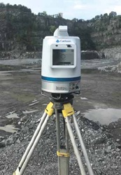
LIDAR Scanner Bridges Gap
Carlson Software showcased the Carlson
Scan2K, set to soon be co-released with
software. The laser scanner is equipped
with an integrated high-resolution camera,
inclinometers, a compass, a L1GNSS
receiver and weatherproof housing, and
is designed to bridge the gap between
small short-range sensors and large longrange
sensors, the company reported.
It is a high-accuracy, LIDAR scanner
that is extremely easy to use and easy to
integrate into existing or new slope stability
monitoring solutions, Bradley James
Husack, special project engineer, Carlson
Software, said. The amount of training in
the use and setup of the Scan2K is very
minimal and very intuitive. That combined
with the lower cost of ownership
and enhanced operational capabilities,
the Scan2K is a great choice.
 The Scan2K is designed to fill the gap
between smaller
short-range scanners and
bigger long-range scanners.
Unlike other
LIDAR scanners, Scan2K can operate in
mines that use prisms in slope monitoring. (Photo:
Carlson Software)
The supplier adopted the LIDAR technology
last year and announced Scan2K
in early 2020. The solution exemplifies
how far LIDAR in general has evolved in
two decades, Husack said. The Scan2K
can and does provide an effective and
economical solution that can help enhance
and help with stability monitoring.
Company literature described the
scanner as perfect for all applications,
with programmable data collection rates
that enable a range of up to 2,000 m. It
has a range accuracy of 5 mm at 100 m
and a range resolution of 2 mm.
Features include three range settings:
250 m, 750 m and 2,000 m with associated
pulse rates of 500 kHz, 200 kHz and
50 kHz, respectively, Husack said. For
each pulse at those data rates, the scanner
will record up to four returns, which is
extremely helpful for vegetation and dust
penetration and bare earth applications.
The vertical view can be adjusted from
the maximum 120° to a narrow field, he
said. This will allow the system to collect
data at the set data rates over a smaller
vertical field of view, which will allow
denser data point collection.
The variable range, scan rates, and
vertical view allow for customized and detailed
scanning of areas of concern.
The Scan2K will also work with survey
prisms that are in the scanners field of
view that might be mounted or positioned
on the target area slope that are being used
for other methods of monitoring, Husack
said. Why this is important is that other
LIDAR scanners will shut down if a prism
is detected or encountered in the scan as
a means to protect the optics of the scanner,
he said. The Scan2K was designed
in such a way that it will be protected and not shut down when it encounters these
prisms at typical monitoring ranges.
The scanner can be mounted on a tripod,
vehicle or moving platform. It can be
wired for power and data or can be battery-
powered and wireless.
It can be controlled by an onboard
touch-screen color interface that remains
visible in direct sunlight or, remotely, by
a tablet or PC running ATLAScan Software,
a data management system for
scan projects.
ATLAScan offers target-free automatic
alignment, 3D meshing, automatic
line features extraction and monitoring.
Scan2K can be paired with Point Cloud
Software, which offers automation for
large data sets. The software can process
millions of data points and has the ability
to go from field scan to finished plat.
The scanner can also be controlled
by third-party slope stability monitoring
applications.
Aggressively priced, the Scan2K was
set for market release in H1 2020, but
was delayed to Q4 due to the lockdowns.
The introduction of the most versatile
terrestrial laser scanner on the market
now is a subtle flex by the supplier, Husack
said. This shows the forward-thinking
and evolution of Carlson Software.
Integrated Software
Optimizes Modelling
Seequent released GeoStudio Core,
which integrates the three most heavily
used programs in the GEOSLOPE suite
and offers comprehensive modelling of a
wide range of soil and rock behavior.
GeoStudio integrates SLOPE/W for
modeling slopes; SEEP/W for modeling
groundwater; and a reformulated SIGMA/
W, with a comprehensive material
model library and automated strength
reduction stability analysis, for modeling
rock and soil deformations.
The integration allows users to conduct
multiple analyses all within a single project
file, Seequent said. Results from one
analysis can be used by another, or analyses
can be made to simultaneously model
stresses and groundwater flow, said Paul
Grunau, president, GEOSLOPE, Seequent.
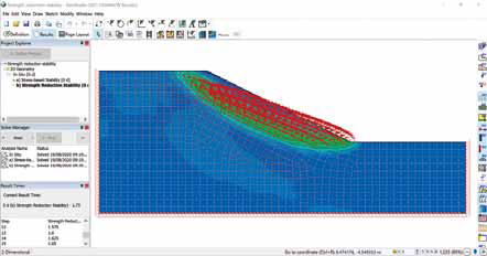 Geostudio Core integrates the three most popular GEOSLOPE programs. One is a new version of SIGMA/W,
rock
deformation modelling software with a comprehensive material model library and automated strength
reduction
stability analysis. (Image: Seequent)
GeoStudio supports multiple geometries
within a single file, making it easy to compare
the effect of mine geometry on stability
and groundwater flow, he said. It is also
multidimensional, meaning that 1D, 2D,
3D, Plan View and Axisymmetric are all contained
within a single project, with results
seamlessly shared between 3D groundwater
flow analyses and 2D stability analyses.
Thus, it offers the most rigorous
saturated-unsaturated groundwater flow
formulation in the geotechnical software
market, Grunau said. GeoStudio is the
only solution in the world offering the capability
of conducting both a General Limit
Equilibrium analysis and an automated
Strength Reduction stability analysis within
the same modelling environment.
The integration empowers the user
to analyze the entire lifecycle of a mine,
from conception to closure. It can create a
digital twin of a mine for use in detecting
and resolving all potential failure mechanisms,
Grunau said. It allows the engineer
to make confident decisions regarding
mine design, he said.
GeoStudio Core is a Windows application
available by subscription. It can be
run as a standalone application. Or, when
used with Seequents Central, for cloudbased
file management, and Leapfrog, for
digital twin management and modelling,
it can offer a single source of truth in
change management.
As featured in Womp 2020 Vol 11 - www.womp-int.com