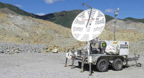
Groundprobe monitoring equipment in action at Bingham Canyon copper mine in the U.S.
(Photo: Kennecott Utah Copper)
Slope Monitoring in the Spotlight
We investigate the drivers behind the host of new geotechnical monitoring
products that have launched this year
By Carly Leonida, European Editor
A landslide at a gold mine in the Tibesti region of Chad killed 30 people in September, and three workers lost their lives at an open-pit mine near Milas in Turkey in February thanks to a landslip. These are just a handful of incidents that have made their way into mainstream media coverage this year; there will have been many more that have gone unreported and, of course, its impossible to talk about slope stability without mentioning the tailings dam collapse in Brumadinho, Brazil, in January where 248 people lost their lives.
While coverage of tailings-related events has done much to highlight the importance of slope monitoring systems, managing and preventing landslides at these types of facilities deserves its own article, and for the purposes of this feature, lets stick to examining slope stability in open pits exclusively.
Tailings facilities aside, its fair to say that slope stability is currently having a moment in the spotlight, and this is likely to continue as next year will see the return of the biannual International Symposium of Slope Stability in Open Pit Mining and Civil Engineering, better known as the Slope Stability 2020 conference. The forum, which is convened by the Australian Centre for Geomechanics (ACG), will take place from May 12-14 in Perth, Western Australia. Its seen as the go-to event for open-pit mining and civil engineering practitioners, consultants, researchers and suppliers from across the globe, allowing them to exchange views on best practice and state-of-the-art technologies.
The topics of pit slope investigations, design, implementation and performance monitoring are expected to take center stage next year, and a workshop has been added specifically to cover instrumentation for slope monitoring. This ACG workshop will focus on new developments relating to conventional terrestrial monitoring systems such as open-pit radars, prisms, laser scanning, and photogrammetry, as well as the integration of the different types of these monitoring systems and their interpretation, the ACG said on its website. Considerable advances have also been made in remote sensing using different types of unmanned aerial/piloted vehicles (UAVs) for slope monitoring at mine sites, and for in-ground monitoring techniques, both of which will also be covered in the workshop.
Current Challenges
Before talking about advances in slope
monitoring technologies, it is pertinent to
look at the challenges that open-pit operators
are currently up against.
Successful slope stability design is,
and has always been, dependent on striking
the correct balance between an acceptable
level of stability and optimizing
the economic extraction of an orebody. To
achieve this requires expert input early on
in a project, adequate geotechnical data
and sufficient slope stability analyses to
justify the mine design.
Australia-based consultancy firm, AMC
Consultants, has deep expertise in slope
analysis and design. Meredith Goss from
AMCs geotechnical team in Melbourne,
spoke to E&MJ about some of the challenges
facing open-pit operators today.
Due to project economics, geotechnical engineers are often expected to give aggressive slope designs using a very limited amount of data, she explained. Mine designs can be exposed to risk due to low confidence in the geotechnical data, and often there is little attention paid to hydrogeology in the initial stages of design. It is necessary to obtain a balance between an optimal mine design based on economics and allowing for contingency, that is, having some flexibility available to adjust the bench configuration in the mine design in the event of unexpected ground conditions. Slope design does not stop at the project stage, but geotechnical data collection (drilling, mapping, data processing and monitoring) needs to continue throughout the operational life of the mine, and the data needs to be incorporated in the pit design and mine planning process.
Goss noted that mine operators have become more aware of the risks associated with slope stability in recent years, however, this is often dependent upon the size of the operation. She added that finding and employing experienced geotechnical engineers for site-based roles remains one of the greatest challenges that mines face. As such, geologists are often required to complete routine geotechnical data collection and processing in addition to their other duties. This makes digital data collection systems that can present accurate and timely data in an easy-to-read format all the more valuable.
The capability of monitoring systems on the market is continually improving, especially for monitoring larger scale displacements, she said. It is necessary to get the correct proportions of knowledgeable people on the ground, machine monitoring, data collection, and analyses to understand the rock mass conditions. Generally, the use of expensive monitoring equipment is driven by economics, for example, economic gains brought about by having steeper pit walls will pay for a radar or a rock fence. The challenge is ensuring the data is communicated through the business and mine planning process.
To date, AMC has completed more than 60 detailed open-pit benchmarking studies worldwide, including productivity and cost benchmarking. Most of the studies conducted during the past year were for return clients that rely on AMC to provide independent accurate benchmarking information. The companys methodology allows the comparison of a sites performance to a cross-section of comparable operations, helping them to achieve superior results.
Mines Delve Deeper
AMC also assists clients with reviewing
current slope designs, continuous improvement,
benchmarking studies to establish
the exposure to risk, and evaluating
the economics of mining deeper pits
or heading underground.
As pits become deeper, the economic
drivers for steeper slopes become more
significant, and it becomes much harder
to include conservatism or flexibility in
the design to allow for unforeseen changes
in geotechnical conditions. The aggressive
slope design angles, which are often
adopted to make deep pits economically
viable, increase rockfall risk through crest
loss, filling of berms, increased frequency
of rockfalls and slope failure.
So, how can engineers determine the safe depth limit for an open pit and whether to continue mining from the surface or head underground? Goss explained: There is currently no defined safe depth limit for an open pit. The decision to head underground is affected by economic and safety risk, and the size and shape of the orebody. Again, this serves to emphasize the need for a reliable and robust monitoring system. However, as with many decisions, the cost of monitoring needs to be justified.
Not everyone is going to be able to afford a radar, said Goss. The cost must be weighed against the potential benefits of managing the geotechnical risks, e.g., rockfalls, structural failure or overall wall failure. How fast is a failure likely to occur: hours, weeks or months? Different monitoring systems will be more or less effective depending on the anticipated rate and mode of failure. Understanding the limitations or blind spots for each monitoring technology is important. The monitoring system should comprise of several technologies that can be combined to give an overall picture of what is occurring.
It is necessary to consider whether the monitoring system will send alarms for operational hazard management, in which case real-time data collection and continuous radio/telecommunication links are required. Alternatively, the system may be intended to collect background information that helps better understand the geotechnical behavior of the mine. Accessibility and reliability are key considerations, particularly in large pits, as access along benches and berms is often restricted and there may be no access for personnel to install instruments or collect data, and a remote method may be required. Goss told E&MJ that AMC is also seeing more requests for assistance from mines with aging infrastructure and long lives remaining.
The requests include reviewing current slope designs and providing advice on management of ground conditions, while finding opportunities to implement new world-class technologies, which will optimize the mines for the future, she explained. The AMC team works collaboratively with mine personnel, undertaking a logical and phased sequence of mining support services with practical mining method solutions and technologies.
Tech Talk
IDS GeoRadar, part of technology giant
Hexagon, is one of a handful of vendors
that is leading the way when it comes to
next-generation mine slope monitoring
systems.
Anna Serangeli, sales operations offi-
cer, at IDSs Mining Business Unit, spoke
to E&MJ about the biggest advances seen
in slope monitoring technologies and
practices in recent years.
The introduction of synthetic aperture
radar (SAR) technology has given
users the possibility of having higher spatial
resolution, longer working distances,
faster scan times and a broader area of
coverage all in one product, she said.
We have come a long way since depending on instruments such as inclinometers and extensometers, but aside from this, the improved performance of slope monitoring radars has allowed for their use to extend to other forms of monitoring. For example, focus monitoring of known instabilities close to working areas using a compact portable radar, or background monitoring of very small movements, which provide data that is then used in modelling and mine design. When designing software, the focus is on making products accessible virtually anywhere (cloud based) and combining available technologies into one visualization and analysis platform, as well as ensuring integration with the various technologies and providers used at a site.
Having smart data management platforms allows mines to maintain a real-time alarm system, and also collect data on events for analysis and planning optimization, said Serangeli. IDS has found that the complexity of managing safety while mediating other essential functions of the mine such as planning and operations, is one of the major challenges that its customers face.
Serangeli explained: Its hard enough to make sure that safety precautions and interventions have the least possible impact in standard conditions. Doing this in a situation where an instability needs to be monitored and safety procedures are in place is even more difficult. This is often rendered even more challenging with the amount of work that a team has to follow, and the reliability and availability of data is the best way we can help our customers in making their jobs easier.
IDS Offers Intelligent
Slope Design
IDS has launched a couple of new products
for the slope monitoring market
this year including GeoMonitoring Hub
and RockSpot.
GeoMonitoring Hub is an example
of the importance of integration that is
requested from our customers today,
Serangeli told E&MJ. A software is now
able to combine, analyze, visualize and
cross-check all measurement results delivered
by automated monitoring systems,
such as Total Stations, GNSS, radar systems,
geotechnical and environment sensors,
InSAR, as well as manual readings.
The work of geotechnicians is based on
the ability to use complex data coming
from many sources, and the possibility
of having a holistic view of the available
data, is highly appreciated.
RockSpot, which was announced in May, is a radar system that can locate, track and alert on rockfalls in real-time. While interferometric radars and laser scanners can monitor the period before and after a rockfall event, the very sudden nature of a rockfall makes it difficult to detect using existing technology. RockSpot is specifically designed to pick up on movements that are too fast for interferometric radar and laser scanners and can track the event as it happens with detail on the trajectory, runout and speed of the fall.
In September 2018, IDS also announced it was partnering with geotechnical expert, Rocscience, to integrate deformation monitoring data from IDSs slope monitoring radars into slope stability numerical models in Slide3 and RS3. The company said this move was an industry first, and an important step toward intelligent slope design, but what exactly does that mean?
This integration is a very important one for our customers, said Serangeli. The use of advanced radars will result in faster and smoother work for geotechnical engineers. The next releases of Slide3D and RS3D from Rocscience will feature a direct communication with IBIS Guardian technology through an application programming interface (API). Users with the Guardian API will be able to automatically schedule and import radar maps into Rocscience geotechnical models, without the need to manually export/import. And thanks to the latest ArcSAR technology, it is now possible to capture deformations every minute on an entire slope.
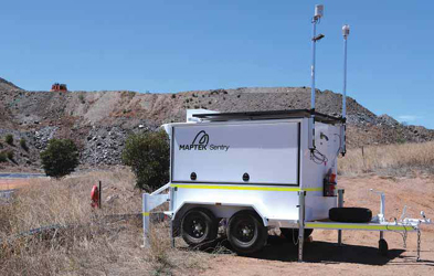
Cold Weather No Longer
an Issue
IDS is not the only vendor that has been
busy. In March, Maptek released a cold
climate version of its award-winning mobile
Sentry system for stability monitoring.
Product manager, James Howarth, explained:
Risk management remains a priority.
If anything, the reliable operation of
technical equipment is even more critical
in extreme conditions.
Sentry is a mobile remote-monitoring
system that uses laser scanning to continuously
measure ground movement with extremely
fine spatial resolution and accuracy.
Housed in a self-contained unit with autonomous
power and communications capabilities,
it relies on sophisticated software to
monitor, analyze and report in real-time.
Maptek redesigned all of the major components in the standard temperature Sentry mobile system, with significant changes to achieve the required cold climate specifications. The new system can operate continuously from -20°C to +50°C, with operation for a limited time in temperatures below -20°C. It features an XR3 cold climate laser scanner, which has been redesigned and tested to operate at low temperatures, and a removable neoprene jacket for the scanner to provide extra protection against wind chill.
In very cold conditions, the charge acceptance of batteries is low, so the battery pack and housing in the Sentry M20 have been redesigned and insulated to keep the unit at a stable operating temperature. Other built-in elements such as generator, hydraulics and electrical systems were adapted to maintain energy efficient, cost-effective operation. Users can customize monitoring frequency and thresholds to meet strategic design and operational planning needs, and provide accurate, timely reports to geotechnical teams and management for managing risk and safeguarding operational environments.
The 3D point cloud data that is collected can be used for geotechnical analysis and other applications. The data can be analyzed by either Mapteks Sentry monitoring package or its PointStudio point cloud processing software to look for deformation between scans.
Maptek Makes Over I-Site Studio
PointStudio 8, which is the latest version
of the software, was released in December
2018. It represents the next step from Mapteks well-known I-Site Studio point
cloud processing and modelling package.
The new generation 3D platform for
modelling, analysis and reporting is
delivered on the Maptek Workbench,
which allows data sharing with other
Maptek applications.
Customer needs were the key mindset behind the PointStudio release, Howarth said in the press release. A modern ribbon interface improves usability and means faster uptake for new users. One of the benefits of moving to the Workbench is access to the Workflow Editor for building interactive command sequences. PointStudio users can link workflow components to data and easily run automations in context. A good example is site-configured registration workflows. This incorporates data import and filtering, as well as all the steps required for getting a registered point cloud ready for processing and analysis, said Howarth.
The three-week remediation work included construction of an access ramp, removal of overhang by scaling and blasting, scaling back the scarp and removal of ramp and rockfall debris. During this, Maptek Sentry Patrol was set up on a tripod in the base of the pit to monitor wall movements. This allowed the best line of sight for the laser scanner compared to crest locations, to detect potential rock movements. Periodic monitoring with the Patrol system mounted on a tripod, wall or bollard allows large scenes to be quickly captured, helping to determine zones to watch more closely. Continuous monitoring can then be used where conditions pose the greatest risk, providing real-time accurate data to guide safety management programs.
Hillgrove Resources said this approach had proven very successful. No wall movements were observed above the remediation works other than the scaling effects and minor mesh movements. Following the success of the remediation work monitoring, Hillgrove Resources decided to staff the Sentry Patrol system with trained pit technicians to monitor on a three-minute scan basis whenever personnel are working on the west wall. A Wi-fisystem allows geotechnical staff to remotely access the system to assist in interpretation 24 hours a day. The setup will continue throughout the final 36 m of excavation of the 350 m deep, steep-walled pit.
Orica Monitor Provides
Data Aggregation
GroundProbe and Nitro Consult are now
part of Orica Monitor, a newly formed
business stream of global explosives expert,
Orica. The division was set up to
provide geotechnical monitoring solutions
to the global mining and civil construction
industries and launched its first
product in August.
MonitorIQ is a data aggregation software that provides users with a holistic visualization of all sensor data across a mine site for accurate analysis of geotechnical and environmental conditions. It helps mines safely execute blasts while maintaining the integrity of surrounding pit walls. MonitorIQ allows users to collate and compare data from more than 120 sensor types on one platform including the suite of radar, laser and vibration monitors provided by GroundProbe, as well as prisms, piezometers, drones, temperature readers and air pressure measurements.
The new software can also consolidate data across multiple sites including mines, tailings dams, natural landscape hazards or built structures. MonitorIQ comes with GroundProbes geotechnical analysis software, SSR-Viewer, fully embedded. This gives users access to SSR-Viewers suite of visualizations and safety-critical charting and alarming tools, on-the-fly, direct from MonitorIQ. MonitorIQ completely eliminates the need for users to switch between multiple platforms when working with any data collected on-site, said Lachlan Campbell, GroundProbe vice president of marketing and technology, on the launch.
This combined with SSR-Viewers deep dive analysis capability presents an interface that is integrated and intuitive. Like IDS, Groundprobe also teamed up with Rocscience in April to allow GroundProbes Slope Stability Radars or lasers systems to import data into the Slide3 and RS3 slope stability programs. The data can then be automatically visualized with the geotechnical model, inclusive of factor of safety heatmaps and probability of failure models. Users of GroundProbes SSR-Viewer software can also import Slide3s 3D failure model as a layer, allowing the model to be overlaid with real-time deformation data.
Having the data flowing two-ways between a geotechnical modelling package and a geotechnical monitoring package means engineers can perform a deep-dive analysis in either software. Users can verify their geotechnical model assumptions with the radar data overlaid in Slide3, while another could be using the geotechnical model in a real-time monitoring system to see the spatial changes in deformation over time.
The Slide3 platform allows geotechnical engineers to calculate the factor of safety of complex 3D slope stability geometries that 2D models cannot fully simulate. It also allows for the modelling of advanced geometries like landslides, MSE walls, slopes supported by soil nails, and more. With Slide3, users can calculate failures in any direction without the need for defining the direction in advance, increasing efficiency in modelling and analysis.
Reutech Launches
MSRIV Esprit
South Africa-based Reutech Mining
launched its fastest scanning slope monitoring
radar in July, the MSRIV Esprit.
The company said the high scan speed
ensures early detection of developing
slope failures at mines and enables accurate
detection of fast-moving slopes in
rapidly changing atmospheric conditions.
Esprit uses the latest core radar technologies to increase the safety reaction time between first warning and the possible event of a slope failure, thereby contributing to the confidence of mining operations. Product Manager Neville Greyling explained that the MSRIV Esprit can scan an area of 22 million m2 at an operating range of 4,000 m in less than two seconds. Due to the fact that an entire area is measured instantaneously, we can provide the truest, up-to-date slope data, he said.
Coupling instantaneous 3D area measurements with a fast scan time allows slope velocities of up to 13,500 mm/h to be attained during critical monitoring. Additionally, during strategic monitoring, smaller movements can be detected with greater accuracy. This means predicting potential failures earlier and increasing warning times. It will result in overall safer openpit mines in areas prone to fast moving slopes, and with rapidly changing atmospheric conditions, added Greyling.
GEOSLOPE Joins Seequent M&A activity has also been on the cards this year. In October, GEOSLOPE, a Canadian company that creates geotechnical analysis software announced it would become part of geoscience software leader Seequent. GEOSLOPE President Paul Grunau said, Over the years, we have invested in the long-term growth of the company to develop a set of world-class solutions for geotechnical engineers. Joining Seequent presents the opportunity for greater integration of geotechnical analysis into the overall engineering and design workflow, thereby enabling our customers to more effectively analyze their problems and deliver better outcomes.