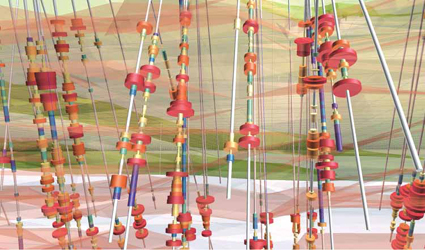
 As an example of the increasingly sophisticated software available for exploration project planning
and design,
Micromines exploration module includes visualization, drillhole management, analytical
and modelling tools,
and statistical/geostatistical functionality. Shown here, the exploration module
uses drill hole solid traces to
visualize the location of high-grade ore within an orebody. The cylinders
are colored and sized by grade.
As digitization gathers speed throughout
the mining industry, the exploration sectors
path forward seems likely to follow
a route increasingly dictated by numbers.
Recent industry announcements and reports
from sources along the exploration
spectrum drilling service companies,
junior companies and major diversified
producers point to a growing focus on
achieving better metrics in practically every
facet of exploration activity, at a lower
cost and with greater accountability.
Thats because recent numbers arent
good. Over the past decade, major deposit
discovery rates in some major metal
categories have dropped to zero, while
the cost of exploration activities continues
to rise. Potential finds may be under
deeper cover, located in more-remote regions,
and as the recent abduction and
killing of a Canadian geologist in Burkina
Faso illustrates, rising occurrences of local
conflict and political unrest heightens
the risk level. Major producers are under
pressure to replace reserves depleted by
mining, but discovery rates and tonnages
have dropped to levels that observers
predict wont allow producers to maintain
production levels in the not-too-distant
future. Copper, for example, seems particularly
threatened by this trend.
Kevin Murphy, senior research analyst
at S&P Global Market Intelligence, noted
in a recent report that
increased copper
exploration budgets have so far failed
to identify more new discoveries, with
only about 140 million metric tons (mt)
of copper defined in 29 discoveries over
the past 10 years, compared with 862.8
million mt in 191 discoveries in the preceding
18 years. According to his report,
current lead times for copper mines are
about 20 years for an asset to advance
from discovery to production: This timeline
implies that the reduced discovery
rates of the past decade will limit the pool
of projects that could come online in 15
to 20 years, and there could be a lack of
quality assets available for development
in the longer term.
Needed: Data Diligence
One of the traditional hindrances to exploration
success is that essential information
is almost always subject to
interpretation, leading to subjectively
based decisions and biases. Important
numbers can range from stats as clear
as grams-per-ton results from drill-core
analysis to fuzzy estimates of project risk
evaluations based on everything from a
targets geological setting and mineralization
characteristics to commodity
prices and country risk. Any significant
item, or range of items, that is mistranscribed,
misinterpreted or simply missed
can alter the overall picture available
to an exploration team and yet, the
amount of data requiring analysis is
growing at a remarkable rate. The latest
technologies and instruments available
for core logging, for example, can generate
as much as 122 gigabytes of data
from a single, typical drill hole.
Technological improvements in drilling
and sampling tools, field data collection
systems, global and local communications,
computing power and data visualization should enable exploration
teams and managers to make quicker,
better-informed decisions. If they can
meet the challenge of turning a rising tide
of available data into a pool of useful information,
free from subjective influences
and in a standardized format. There is a
rapidly expanding universe of hardware,
software, and data-service tools and resources
designed to help companies solve
this many-faceted problem. Solutions
range from systems and software that
allow exploration teams to bypass manual-
entry-on-forms and eliminate paper
maps and documents altogether, to Artificial Intelligence (AI) technologies that
not only can be trained to read, digest
and make recommendations from myriad
data sources but also can go back in time,
if necessary, to reinterpret historical data
and reports in accordance with more recent
developments and insights.
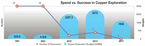 Source: Selected data from S&P Global Market Intelligence, Copper Discovery Rates Plummet.
Customary practice in most exploration
programs involves initial data
collection compiling pertinent information
from existing records or manually
by field studies, or both, followed by
mapping at various levels of detail. From
an information technology perspective, a
paper-based approach to this process is
unacceptably inefficient, and improvements
based on eliminating paper forms
and maps have been low-hanging fruit for
IT companies, which have been quick to
develop solutions more in line with corporate
digitization initiatives and objectives.
To illustrate the progress made in
this area, Mark Gabbitus, product strategy
manager for software developer Micromine,
presented a paper at the inaugural
Australian Geoscience Council Convention
(AGCC) held last year in Adelaide
that described his companys strategy for
optimizing the process using connected
devices and edge computing.
Gabbitus said Micromines focus on
exploration began in the early 2000s with
the release of Field Marshal, a field data
capture product designed to replace paper
log sheets, and has continued into the
present with recent releases of Geobank
Mobile, which facilitates integration with
data capture devices such as magnetic
susceptibility readers, portable XRFs
and geotechnical measurement devices.
These devices, according to Gabbitus, are
often connected to a service or database
in the cloud, but someone, somewhere
still needs to merge it into the master
database at some point. Issues also can
arise when there is no network connectivity,
a common issue on the edge.
If an exploration geologist can collect,
validate and access their data in
a single platform, while they are in the
field, real-time insights can be drawn, enabling
smarter decisions at the rig, he
said. Having this data available would
then allow a geologist to make decisions
in the field, to end a hole early or justify
extending a hole beyond its planned
depth. This adds immediate value, either
by reducing planned drilling costs or preventing
costly re-drills later.
The computing power available to field
personnel in a ruggedized format has improved
to the point where not only can a
geologist run Geobank Mobile, said Gabbitus,
but also can run Micromine, the
companys flagship modular exploration
and mine design suite, on a tablet.
Join the SRK.IS
Maps have always been essential in the
exploration process, likely starting with
crude X marks the spot diagrams used
by prospectors in past centuries and progressing
to the detailed prospect maps
produced by exploration teams today. But,
as Jason Beltran, a senior GIS consultant
for SRK Australia, pointed out in a recent
exploration newsletter, traditional paper
maps are static, limited to the size of the
paper on which they are printed, and difficult to read when they contain dense detail.
The solution: either split a map into
separate sheets or remove some of the features,
which lessens the maps usefulness.
Now, in a digitally connected world,
smart devices can be used for collecting
and sharing mapping data, enabling geologists
to produce accurate digital maps collaboratively
and more quickly, and without
the limitations of size and scale. SRK has
leveraged a customized in-house mapping
portal using ArcGIS technology initially developed
by ESRI using IS for information
system, its called SRK.IS (pronounced
circus). SRK.IS works with Web apps
that are customized for a particular client
or project. Essentially, SRK.IS integrates
digital data collection in the field with a
centralized database, making it possible to
access maps and other geographical information
in real time and viewed by a variety
of users simultaneously.
The advantage of SRK.IS, said Beltran,
is that it provides different connection options,
whether the data is collected in the
field or viewed and/or edited in a clients
office. Using ESRIs ArcMap or ArcPro, the
data is transferred to maps in the SRK.IS
Web app and published as a map service
to SRK.IS, so users can interact with the
map service. The level of accessibility is
subject to the map service requirements
and user permission settings.
For collecting data, SRK.IS connects
to a dedicated ESRI application called
Collector for ArcGIS, which works on Android,
iOS and Windows mobile devices.
Data are customized according to the requirements
of the mapping task, and data
pre-filling options can be activated to
save time and reduce exposure to human
error in data entry. Digital photos can be
attached to a datapoint to automatically
georeference the location of each photo.
Users can download maps beforehand,
so data can be collected in remote locations
with no internet or mobile connection.
Later, when internet connection is
available, the offline data can be synced to
SRK.IS and integrated with existing data.
The data on SRK.IS is accessed via a
portal, using a Web browser, or by a direct
Web App URL. The Web browser interface
works like the Google Earth application
by toggling between different map layer
options, users can control the geospatial
information to view. Office-based ArcGIS
administrators can log in to the SRK.IS
portal to view mapping progress in real
time. The data can be edited and synced
back to the SRK.IS user in the field, reducing
any delay from waiting until the
map is produced before processing any
edits and enabling faster map creation
than previously possible.
Portable Productivity
The latest generation of handheld or
transportable XRF analyzers, which allow
quick identification of minerals on-site,
work well with digital data-capture solutions
that eliminate paper-based forms
and documentation and provide quick
information turnaround. These include
units such as Malvern Panalyticals ASD
Terraspec Halo, Spectral Evolutions oreXpress
and SR-6500, Brukers S1 Titan
and Thermal Fisher Scientifics line of
Niton analyzers. X-ray fluorescence, or
XRF, is a process whereby electrons are
displaced from their atomic orbital positions,
releasing a burst of energy that is
characteristic of a specific element. This release of energy is then registered by the
detector in the XRF instrument, which in
turn categorizes the energies by element.
Handheld analyzers are convenient
and adequate for a range of in-the-field
identification requirements, but if greater
accuracy, flexibility and worker safety
(protection from accidental X-ray exposure)
are desired, a range of so-called
benchtop analyzers are available as well.
These can vary in size and configuration
from units the size of a laser printer that
can be used and stowed in the back of
a vehicle or in a site office, to trailer or
containerized setups that are touted as
laboratories in the field.
Recent offerings in this area include
Boart Longyears TruScan, comprising a
trailer-mounted module fitted with sample
handling and XRF scanning equipment.
According to the company, TruScan
is designed to provide same-day continuous
analysis of the drill core and provide
non-destructive, accurate, high-density
elemental concentration data. Boart
Longyears Drilling Services utilizes TruScan
for elemental and photo scanning
of core at the exploration site, providing
geologists access to real-time geological
data as the core is drilled.
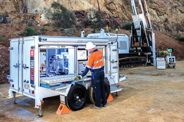 Boart Longyear says its TruScan systen can provide same-day continuous analysis of drill
core and quickly return
non-destructive, accurate, high-density elemental concentration data
In addition, TruScan offers high-definition
wet, dry, and spot-scan photos of the
retrieved rock core. Same-day TruScan
data, according to the company, can be
used by a geologist to log core more accurately
the first time, identify alteration
zones, and determine where to sample
and where not to sample for lab analysis.
In a similar vein, the Swedish-Australian
company Orexplore launched the Geo-
Core X10, a digital drilling cores laboratory,
which analyzes element concentrations
and minerals contained in a drill core and
provides a 3D representation of the rocks
internal structure. Orexplore said the Geo-
Core X10 is designed to work in remote locations
and has several flexible options for
data storage and data transfer. Normally,
the data generated by the GeoCore X10s
high-resolution scanning engine is sent to
a central server where it can be accessed
by Orexplores Insight analysis software.
At sites that have access to a fast network
connection, this is done automatically. In
locations where there is either a very slow or
no network available, the GeoCore X10 can
store data locally on removable SSD (Solid
State Drive) hard drives, which can then
be transported and uploaded to a central
server when a fast network is available. The
drives also can be shipped directly to an
Orexplore office for immediate uploading.
Applying AI
Recognizing the need for overall improvements
in exploration data management and
analysis capabilities, IT companies both
large and small see it as an opportunity
for application of Artificial Intelligence (AI)
technology. Goldcorp and IBM, for example,
have been collaborating since 2017 on
a project aimed at teaching IBMs Watson
AI platform to think like a geologist in order
to make AI-based recommendations on
where the company should focus its exploration
efforts in the Red Lake gold district
in Ontario, Canada. Other companies, such
as Goldspot Discoveries, headquartered in
Toronto, Ontario, and Earth AI, an Australian
company, are recent startups that apply
a branch of AI known as machine learning
to develop and refine mineral targeting
systems that more effectively handle and
analyze the growing volume of data associated
with exploration programs.
Describing the Goldcorp/IBM AI collaboration,
Mark Fawcett, partner, Global
Business Services at IBM, said, One of
the biggest challenges facing geologists is
interpreting the vast amount of data that
includes field mapping data, geochemical
surveys, drill hole data, geophysical surveys,
geological maps, Landsat imagery,
aerial photographs, mine level plans, alteration
models, resource model data and
reports in order to make the best decision
on where to drill next.
Inputting that information into
Watson and educating Watson on the process
of exploration, gives the system the
capacity to make more informed exploration
decisions to improve the probability
of discovery.
The first phase of the IBM/Goldcorp
program involved providing Watson with
structured data from a wide range of
sources, such as geophysical and geological
surveys, drillhole datasets, reports,
academic papers and conference
proceedings, providing insights into Red
Lakes geology, current and historic mining
and exploration activities and successful
exploration techniques.
Phase two is where we start to educate
Watson to refine and build the exploration
model the system will use to
make predictions and provide recommendations
on where Goldcorp should direct
its exploration activities, said Dariusz
Piotrowski, global leader of cognitive and
analytics development for Natural Resources
at IBM.
Exploring New Partnerships
In addition to in-house corporate initiatives
aimed at improving exploration
efficiency and chances for success, companies are forming agreements and
alliances with universities and research
organizations with an eye toward expanding
and/or refining exploration techniques
and knowledge.
As an example, a new four-year, $3.6
million research partnership between the
University of Western Australia (UWA) and
Rio Tinto Iron Ore will lead to improved efficiency in geological modelling, through
innovative data science solutions.
Building on a collaboration that started
in 2010, a new partnership called
Data Fusion Projects involves UWAs geodata
algorithms team working with a Rio
Tinto Iron Ore team led by Resource Evaluation
Manager Thomas Green.
Green said the challenge faced by Rio
Tintos resource evaluation group was to
quickly and consistently interpret and
integrate increasing volumes of different
types of data collected. We were actively
seeking automated solutions not to replace
but to assist our interpretation to
model geology and resource, which can
be inconsistent and uncertain, he said.
The partnership involves diverse
themes including the development of
machine-learning-based methods and
tools to integrate diverse drill hole data
to model stratigraphy, their material compositions
and geomechanical proxies for
resource evaluation and mining.
The research also aims to incorporate
advanced machine learning methods to
improve certainty in modelling the spatial
extent of subsurface geological interfaces.
The team will develop image analysis and
visualization methods and tools to assist
the interpretation of large volumes of 2D
and 3D data from satellites and drones for
planning and geological mapping.
UWA and Rio Tintos past collaboration
resulted in UWAs commercialization
of automated downhole image analysis
software in 2015, and a RTIO-driven joint
patent application in 2017 on Automated
Validation Assistant (AVA) for geological
and mineralogical composition logging
from rock samples from drill holes using
machine learning.
In North America, Vancouver Island
University (VIU) recently announced a
mapping-related research project focused
on the glacial landscape of Canadas
North regions. The project, funded
by Natural Resources Canadas Earth
Sciences Sector, is aimed at assisting in
the development of better remote predictive
mapping (RPM) methods for mineral
exploration.
Traditional methods of surficial mapping,
employing aerial photographs and
field verification, are both time-consuming
and expensive, said Brad Maguire, a
professor in VIUs Geography department.
He and Professor Jerome Lesemann of
the schools Earth Sciences department
are overseeing the project.
The research project aims to develop a
methodology for computerized detection
of the sediment components of eskers
ridges of gravel and sand, which occur
in formerly glaciated regions of northern
Canada, and which can host diamond deposits
and other valuable minerals.
Currently, RPM is a promising avenue
of semiautomated mapping using widely
available digital datasets like multispectral
satellite imagery. However, there
are gaps in the methodology, said Lesemann.
Part of the problem is that the
type of imagery used to date gives us
information about spectral characteristics
of the surface, which reflects mostly
the type of material on the surface, like
bedrock or sand and gravel. The imagery
does not contain information about the
three-dimensional shapes of landforms.
The VIU project team proposes to develop
an esker element detection methodology
based on deep machine learning
supported by a Convoluted Neural Network
(CNN). CNN uses computer algorithms
to try and replicate complex cognitive
processes of the human brain. We
will be using CNN to identify eskers from
newly available, high-resolution digital
elevation models (DEM) of the Canadian
Arctic, Maguire said. Lesemann explained
the aim is to train a computer to
recognize patterns. The form and structure
of eskers are complex and if we can
teach a computer to learn what an esker
looks like, we may then be able to identify
other eskers automatically, he added.
Back in Australia, the newly established
MinEx Cooperative Research Centre
(CRC) began operating last July at
the University of South Australia and in
Western Australia. Supported by a $50
million grant from the Australian government
and more than $150 million in cash
and in-kind support from industry participants,
the MinEx CRC is tasked to develop
cost-effective and eco-friendly mining
technologies related to in-field sensing
and real-time data analytics.
David Giles, chairman of Minerals and
Resources Engineering at the Future Industries
Institute, University of South
Australia, and chief scientific officer for
the CRC, said the objective is to enhance
the efficiency of minerals exploration
nationally. In the Australian context,
the cost of exploration for new deposits
has risen over the past 30 years and our
success rate has declined, Giles said,
noting that cheaper and more effective
drilling technologies have the potential to
improve the discovery and affordability of
identifying new mineral deposits.
MinEx CRC is tasked to implement
the National Drilling Initiative (NDI), a
collaboration of government geological
surveys, researchers and industry that will
undertake drilling in underexplored areas
of potential mineral wealth.
Another part of of MinEx CRCs focus
is to extend the capability of technologies
such as Coiled Tubing (CT) drilling so it
can drill deeper, is steerable and delivers
the highest quality sampling. CT technology
for deep rock exploration, developed
by Deep Exploration Technologies CRC,
holds promise of drilling at 20% of the
cost of conventional diamond drilling and
has been tested at a Barrick Gold site in
Nevada, USA.
In Europe, a consortium of research institutions
and commercial interests have
joined in the X Mine project to look for
increases in exploration efficiency by developing
equipment for scanning drill core
samples on site using new, highly sensitive
layered imaging technology based on
X-ray fluorescence, as well as composition
analyses. The consortium conducted rock
classification trials in late 2018 comparing
the mineralogical results obtained
from Orexplores XRF detector, Advacams
XRT detector and Antmicros 3D camera.
The X Mine project, with funding
through Horizon2020, is an EU research
and development program funded with 80
billion to award to European research initiatives
over a seven-year period (between
2014 and 2020). It is based on international
cooperation between research institutions
from Finland, Sweden and Romania,
sensor and equipment manufacturers
from Finland, Poland, the Czech Republic
and Sweden, and end users such as mining
companies in Bulgaria, Greece, Cyprus
and Sweden, along with Australian
drilling services and equipment supplier
Swick Mining Services.
As featured in Womp 2019 Vol 02 - www.womp-int.com