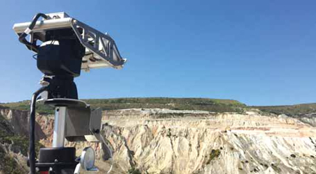
Reutechs Slope Vision system comprises a high-definition camera and advanced software that enables
the user to direct the camera to specific georeferenced coordinates or points of interest.
Measuring Motion: New Angles for
Slope Stability Monitoring
Companies with the best prospects for managing geotechnical risks are committed to
having access to good data, rigorous design and topnotch engineers. Heres a look at
the newest options available to meet the challenges.
By Russell A. Carter, Contributing Editor
However, due to technological advances and higher awareness of the need for solid geotechnical knowledge and advice following various slope failures at several large mines, new geotechnical instrumentation and software solutions have been emerging at a much quicker pace lately. And, as well see later in this article, efforts are under way to attract future geotechnical engineers and train them to more effectively navigate the corporate terrain of a rapidly changing industry.
Interestingly, but not surprisingly, most of the notable technological advances in this area have occurred in three sectors that overlap the industrys current technical focus in general: sensor systems, information management and data visualization. The Slope Stability 2018 conference and exposition, held April 10-12 in Seville, Spain, offered an opportunity for geotechnical equipment and service providers to showcase their latest offerings, many of which featured new capabilities drawn from those three technologies. In particular, radar- and LiDAR-based systems both already in wide use throughout the industry, and now incorporating both ground- and satellite-based technology continue to evolve with expanded feature sets and better data collection and management capabilities.
Reutech Offers an Independent View
Reutech Mining introduced two new products
at the conference the Slope Vision
georeferenced camera system and MSR
Connect software suite. Slope Vision, according
to the company, is an advanced
georeferenced camera. While performing
real-time monitoring utilizing Reutechs
Movement and Surveying Radar (MSR),
Slope Vision provides the user with an
independent view of the pit. Once slope
instability is detected, the camera can be
pointed to the affected area that allows
the radar to continue with its prime function,
said Daryl Grobler, project manager.
In an operational environment where
reaction time is critical, and manpower
limited, Slope Vision offers an extra pair
of eyes when most needed.
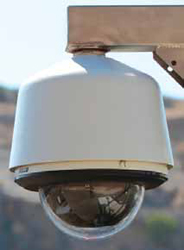
Grobler added, The high-end camera has 30X zoom, low light capability and a cold temperature rating of -45°C (standard) and -51°C (extreme cold unit), which allows it to operate in low temperatures and other adverse conditions. It has user-friendly georeferencing software when coupled with the MSR system. The user can view a scanned point in real time, as well as record the video. In addition, you can edit and save the recorded video, with the added benefit of encrypting the saved video if needed.
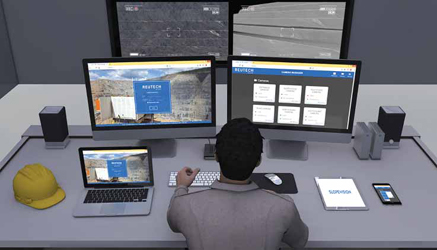
Reutech said its MSR Connect software brings a modern human machine interface to its MSR slope stability radar systems. Utilizing a Web-based viewer, it provides increased versatility. Clients now can enjoy access to multilingual real-time information, no matter where they may be located, said Garth Day, Reutechs business manager for South America.
The flexibility of this system allows the user to access information with their choice of device or operating system. An on-site geotechnical engineer analyzing live trend graphs can now make use of an Apple Mac or a Windows desktop to view trends. At the same time, the mine manager, who may be off site, can get a view on his or her Android smart phone.
What excites me most about our new MSR software is that it speaks to the current and future requirements of an ever-changing industry, Day continued. Fast, reliable accurate data linked with ease of use and access, these are some of the key requirements of our clients today. MSR Connects Web-based browser is a fundamental shift from how data is assimilated, processed and distributed.
Customized reports and dashboard view are notable additions to further enable the dynamic decision processes that are required for the job. This allows the user to create a custom dashboard display with reports that are specific and relevant to the task at hand. This has opened up a host of new possibilities previously not available to MSR users and makes way for increased capacities on all levels, starting with big data management and processing, including enhanced analyzing capability, he explained.
Earlier this year, Reutech announced that it had added sensemetrics Inc. as a distributor for its product portfolio in the North American market. Based in San Diego, California, sensemetrics develops cloud-based, enterprise-level sensor management and data analytics solutions for mining and other industrial sectors.
Laser System Leaves Prisms Behind
GroundProbe, now part of Orica, introduced
its first laser-based monitoring
solution to give early warning of impending
collapses of open-pit mine walls that
can begin months or years before a collapse
occurs.
The company said its Geotech Monitoring Station (GMS) replaces traditional total stations that rely on mirrored prisms installed on a slope. The system can scan prisms, but can also reflect its signal directly off the rock, thus reducing the need for a risky industry practice. Prisms can be dangerous to install, inflexible to changing ground conditions, and their repair or replacement can be unsafe, time-consuming and expensive, said Lachlan Campbell, GroundProbes vice president of marketing and technology.
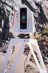
As an Electronic Distance Measurement (EDM) LiDAR, the GMS monitors through automatically measuring up to a thousand discrete points on a wall, in the form of physical and virtual prisms. According to Product Manager Fernanda Carrera, The GMS monitors vast mine areas for long periods of time of many months to many years. It specializes in background monitoring in open-cut pits and highly vegetated slopes, as well as detecting and measuring small-scale movement on tailings dams, dumps and cuttings that precede a collapse.
Our patent-pending visualization technique that co-locates data with the ultra- high definition images captured by the GMSs dual cameras is a step-change in data visualization for prism monitoring, said Carrea. Automatically visualizing data and heat maps on high-resolution photos, or in 3D, sets the GMS apart from existing solutions, which often force users to view data in a table rather than more intuitive visualizations. The dual-camera imaging capabilities of the GMS, wide angle and telescopic, permits users to precisely see and control the locations of points in real time while providing the ability to conduct remote visual inspection.
The company said its SSR-Viewer software platform for its lineup of monitoring devices was updated to support all GroundProbe Series-2 and Series-3 radar technologies 3D Real Aperture Radar, 2D Real Aperture Radar and 2D Synthetic Aperture Radar as well as the new LiDAR-based technologies, the Geotech Monitoring Station (GMS) and Geotech Monitoring LiDAR (GML).
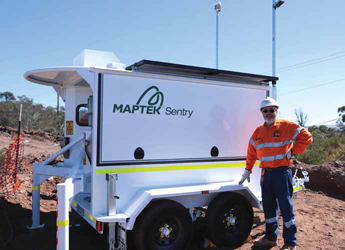
Maptek Makes Its LiDar System Mobile
Also on display at the Slope Stability
conference was Mapteks Sentry LiDAR
system. First introduced in 2014, the
Sentry system combining an I-Site
laser and software was re-launched
last year as a fully transportable package
for detecting ground movement. Leading
features of the new system, according to
Maptek, include:
Ability to monitor multiple zones within
a scene without the need for targets
or reference points. Movement can be
detected down to 1 mm per hour.
Most cost effective when used to scan
and monitor several zones concurrently.
Visualization and analysis tools
can be readily deployed for monitoring
on a broader scale before using radar
assets if required.
Time-lapse capability allows users to
see changes and use this information
to predict movement in other areas.
Heat maps colored by displacement or
velocity provide an overview of surface
movement.
Alert levels and rules are easily defined,
allowing critical information to be sent
directly to geotechnical staff or mine
managers so they can decide on an action
to be taken.
The laser scanner can be moved for other
tasks, and monitoring history is maintained
when the unit is returned to the
same fixed monitoring position.
Animation of zones to show morphology
of terrain changes over time.
According to Maptek, the mines geotechnical department needed to implement a slope-monitoring system for active pits, providing greater awareness of areas showing signs of instability. Favorably influencing the mines decision to adopt Sentry, said Maptek, was its ability to generate queries from different areas, providing knowledge of the full history of potential instabilities in sectors where geotechnical information was not available. In addition, the ease of installing the system at different locations met the mines expectation of being able to use the I-Site XR3 laser scanner for other survey applications.
Maptek said the implementation at Shougang took place in a staged sequence, starting with delivery of equipment and accessory requirements for optimal installation of the system, through to completion of the training.
Day 1 of the implementation required
Shougang to provide accreditation passes,
a safety induction, the equipment
checklist, and installation of the Sentry
system at the monitoring point.
On the following day, Maptek gave a
Sentry presentation to Shougang personnel,
and assisted in setting up the
areas of interest, the Wi-Fi network connection
for remote monitoring, and a
test run definition of alert parameters.
The final day included checking remote
access, theoretical training for
Shougang personel, practice using the
Sentry System, and wrap-up of the
implementation.
New Software Brings Faster Data Analysis
In September, IDS GeoRadar announced
that it was partnering with Rocscience
to integrate deformation monitoring data
from IDSs slope monitoring radars into
slope stability numerical models in Rocsciences
Slide3 and RS3 software. This
integration, according to IDS GeoRadar,
is a first in the industry and a step forward
toward intelligent slope design. IDS Geo-
Radar, an Italian company, is part of the
Hexagon group.
IDS GeoRadar said its ArcSAR is the first and only radar in the mining industry to provide 360° pit coverage from a single equipment unit. The system offers long-range capabilities (5,000 m) along with short scan time (360° in 40s; 180° in 20s) and built-in GNSS for auto-geocoding. According to IDS GeoRadar, these advances will lead to faster geotechnical analysis. The radar data will be integrated through a streamlined workflow that will allow geotechnical engineers to focus on modeling and slope analysis rather than waste time importing and converting files.
The company also announced a new implementation of its ArcSAR technology, the HYDRA-X, a high-resolution, high-accuracy, quick-deployment monitoring radar system. It is claimed to provide spatial resolution two times finer than any other slope monitoring radar. IDS GeoRadar said that by close monitoring of hanging benches over working areas or elements at-risk, HYDRA-X can measure sub-bench scale instabilities. With a maximum scan range of 800 m, at-risk areas can be safely monitored even for the smallest rock movement.
HYDRA-X features on-site processing and alarming, an optical HD camera with visual imagery linked to radar data and refreshed scans every 30 seconds. Information is available for quick reaction, even in the case of sudden accelerations, and people are immediately alerted in the field. Its design allows convenient travel requiring only a light vehicle, and single- person operation. HYDRA-X can be supplied with a combination of solar panels and fuel cells, providing 60 days of full autonomy with almost zero maintenance.
The company said HYDRA-X represents the perfect solution for monitoring smaller mining operations where radar monitoring can contribute to the optimization of slope design and extraction planning by improving overall risk management. Its versatility is well-suited for focused monitoring of tailing embankments and working sectors in strip coal mines.
Listening In
Radar, LiDAR and total station/reflective
prism systems are designed to detect
and monitor slope-stability changes expressed by surface movement. However,
microseismic monitoring techniques can
be used to assist in characterizing rock/
structure disturbances behind the slope
before movements on the surface are detected.
By integrating microseismic information
with other surface monitoring
and modeling results, mine operators can
create a reliable assessment tool for slope
management and ground control. Microseismic
monitoring is widely available as
a service package from various providers,
with a range of coverage and interpretive
options offered. Two examples:
Mining3 offers a bespoke microseismic continuous monitoring service to mines with slope stability issues. Mining3 will design and implement the system and offer training to mine geotechnical staff to use and interpret the data. In practice, geophones configured in small arrays are installed in shallow drill holes around slopes of concern. Seismic signals from the geophones are continuously recorded, time-synchronized and transferred via cables and USBs for collection and processing. Both strong and weak microseismic events are measured and assessed to determine their source location, energy and potential impact on slope movement.
Mining3, established in 2016, is a partnership between Australias CRC Mining and CSIRO Mineral Resources Group. CRC Mining, which came into being in 1991 as an entity in the governments national research center program, brings together Australian and international mining organizations in a cooperative effort to develop innovative mining and processing techniques as well as supporting equipment for the industry. Mining 3s research and development initiatives are directed by its mining industry members.
Mining3 said it also is pursuing development of a system with automatic collection and incorporation of high-speed telemetry (e.g., 5G telecommunications) combined with distributed cloud computing and AI technology for rapid monitoring, processing and interpretation of results in near real time.
Ontario, Canada-based ESG also provides microseismic technology for mining and geotechnical applications. According to the company, its complete microseismic systems are easy to use, modular for simple expansion, backward compatible, and operate in a Windows environment.
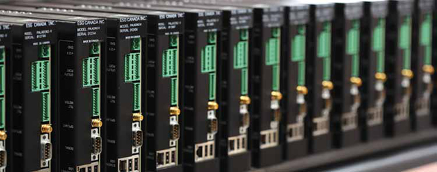
The Paladin 5 is the latest, 32-bit version of ESGs digital microseismic recorder, and serves as the backbone of its microseismic data acquisition system. Continuous recording on all stations at once ensures that no data is missed. Unique triggering methods can be configured to record event data based on specific criteria.
The Paladin 5 incorporates a removable license card that controls the onboard capabilities of the recorder. Similar in functionality to the legacy Paladin Sensor Interface Box (SIB), the license card comes in two forms: In its basic version, the PIV Daughter Card (PDC) offers a geophone pulse diagnostic test. The more powerful Advanced Diagnostics Board (ADB) introduces a wide range of additional features on the PIV, enabling on-board processing and diagnostics capabilities.
The ADB is designed to interface with both geophones and accelerometers. Lights on the front panel indicate channel performance. Advanced diagnostic tools include voltage measurement, sensor auto detect, programmable AC/DC coupling, auto detect-correct polarity, and geophone parameter extraction, among other features. Use of the ADB simplifies installation and provides real-time feedback about the health status of the attached sensors.
As part of its Hyperion Seismic Software (HSS) suite ESG offers SeisVis, a module that enables advanced 3D-visualization and interpretation of site seismicity using event information and scaled-site geometries. Event locations, magnitudes, and site velocity profiles, among other parameters, can be viewed with respect to site geometry or models using a variety of display options. Seismicity can be viewed for specific events or animated over an extended time period using a playback option.
Recipe for Success: Define, Discuss, Debate
In an industry that is as equipment-intensive
as mining, and with a surging
interest in collecting site-specific information
from myriad equipment sources,
it can be tempting for engineering staff
to simply let the data speak for itself,
without critical examination of design
or practice. This applies to geotechnical
issues as well where, as weve seen,
increasingly sophisticated technologies
are making the task of interpreting slope
stability data somewhat easier. Although
its likely that artificial intelligence and
machine learning will become increasingly
prevalent in this sector, theres still
a major human element involved in data
analysis and interpretation, with decisions often being made on the basis of
prior-event parameters and corporate or
personal biases and preferences. However,
leaning too heavily on past experience
to predict future events can lead
to problems, even when the datas good
particularly when independent critical
review is absent.
A case in point is the landslide that occurred in the pit of the Bingham Canyon copper mine in April 2013, regarded as the largest man-made slide in North American history. Two separate slides that happened within a few hours of each other unleashed an estimated 144 million tons of dirt and rock that tumbled 2,000 ft from a point high on the pit wall and spread along a runout distance of almost 10,000 ft, burying the pit floor under 66 million yd3 of material and triggering a mild earthquake under the mine.
The Manefay slide, as it is called, was a financial and operational calamity for the mines owner, Rio Tinto, but from a geotechnical point of view, it could almost be considered a qualified success in terms of how to go about monitoring a potential slide area. The geotechnical staff couldnt prevent the incident, but the mines comprehensive monitoring program allowed them to become aware of the problem months before it happened, keep close tabs on its progress, and recommend timely evacuation of personnel from the pit well before the slope failure occurred.
Even so, the overall size of the landslide significantly exceeded pre-event estimates, and the slide itself was quite different from previous slope failures at the mine. Whereas most earlier slides were progressive in nature, with a gradually accelerating rate of movement culminating in a slide that would slow and stabilize over the course of a day or two, the Manefay incident was actually a rock avalanche, forcefully spewing millions of tons of material from the pit wall, burying the pit bottom with a 600-ft-thick layer of dirt and rock that reached the far side of the pit floor, an area considered safe from the slide where part of the production fleet had been parked during evacuation. More than a dozen haul trucks and three shovels, along with bulldozers, drills and graders, were damaged or destroyed there, and a huge section of the pits main haulage road was obliterated.
Clearly, despite the existence of previous slope failure records, deep professional experience and an extensive geotechnical monitoring setup including slope stability radar units, along with extensometers, a prism network and microseismic equipment the mines geotechnical team was caught off guard by the scope and nature of the slide. What was overlooked, forgotten or disregarded? E&MJ spoke with Brad Ross, a professor of practice and director of the nascent Geotechnical Center of Excellence (GCE), Lowell Institute for Mineral Resources, at the University of Arizona. Ross managed the Bingham Canyon mine planning team before and after the landslide occurred and has authored a book titled Rise to the Occasion: Lessons From the Bingham Canyon Manefay Slide, which provides insight into the events leading up to and in the aftermath of the slide as well as suggestions on how to manage more effectively during both normal operations and crises.
The Manefay slide was a black swan event, according to Ross something that is unexpected, has a major impact and is the first recorded instance of its kind. But, he noted, A black swan event is only a black swan because no one considered the real possibility of the event occurring.
If the way the Manefay failed is classified as a black swan event, what critical control measures can be used to prevent or at least anticipate such events?
Ross recommended three measures that can help to identify and prepare for unique occurrences such as the Manefay slide. However, he cautioned, theres no guarantee that any particular measure could have predicted the scope and effect of that event. He suggested:
Using independent experts Placing too
much confidence on site-specific personal
experience and historical records
can be risky. In the case of the Manefay
slide, outside experts might have
been able to expand awareness of different
slope failure modes, and probably
wouldnt be swayed one way or
another by the mine geotechnical teams
previous experiences and biases.
Challenging the basic assumptions
of your staff Commonly referred to as
wearing a black hat, this involves facilitating
frank, give-and-take discussions
of the problem in a nonjudgmental
environment.
Sharing what youve learned Disseminating
knowledge of the characteristics
and behavior of black swan events may
help others avoid the same outcome.
In a telephone interview with E&MJ, Ross and GCE Assistant Director Chad Williams discussed how mines can develop a robust geotechnical program to effectively recognize and manage slope stability risks. According to Ross, the engineering staff needs access to solid geotechnical input data that supports rigorous geotechnical assessments and designs. This allows them to develop a better understanding of the risks they are managing. Identified geotechnical risks should be entered into a register and assigned appropriate controls through a bowtie or similar assessment.
For maximum effectiveness, a mines geotechnical team should work closely with operations personnel, he said, preferably with ongoing joint participation in slope-stability monitoring practices and testing. A useful tool for site-wide involvement is a Trigger Action Response Plan (TARP), such as the one initiated at Bingham Canyon in the months before the slide occurred. The plan comprised a five-level, color-coded set of trigger levels rated from 0 (blue, normal/stable conditions) to 4 (red, slide imminent or in progress). The daily TARP level was sent to all employees and contractors. For each level, there were separate operations, management and external/security response items, consisting of the predetermined activities that could, or should, take place at each level. In addition to the overall TARP, more-detailed TARPs went out to the operations and maintenance teams.
Both Ross and Williams noted that theres been a discernible rise in interest from mineral producers regarding geotechnical matters over the past several years, with corresponding increases in deployment of radars and other slope stability monitoring equipment, but success in this area largely comes from having good input data for rigorous geotechnical design and competent engineers. The latter factor is probably the most critical at present, due to an ongoing shortage of qualified geotechnical engineers.
Thats where efforts such as the universitys GCE will be crucial in meeting demand, said Williams. The centers proposed curriculum, scheduled to launch next year, will be focused on expanding the number of professionals graduating in the field, promoting professional development for existing professionals, providing training in new technology to monitor and detect potential failures, and helping to update tools and methods to understand and analyze geotechnical risks.
Part of the centers focus will be aimed at preparing students to be able to attack engineering problems in an interdisciplinary manner and break down organizational silos that may exist. As Williams explained, lack of qualified personnel forces operators to outsource geotechnical work to consulting companies, which is a perfectly acceptable practice, but results in most of a mines geotechnical knowledge residing outside the mining company. When using outside consultants on a company-wide basis, theres a possibility that the consulting firm will have a wide-ranging understanding of a companys geotechnical issues, but the in-house geotechnical personnel will have a much more limited view of the available information. The danger here, according to Williams, is that mine operators must have in-house capability to understand the risk they are managing, and to direct geotechnical work that cant be outsourced. And, he added, consulting firms are having their own difficulties finding qualified staff.
Another GCE objective is establishment of a global database of monitoring failure signatures, basically, the information provided by a sites geotechnical monitoring equipment before and after a slope failure occurred. Such a body of information, said Williams, could allow geotechnical staff and researchers to compare cross-site information and make better decisions on design, analysis and risk management. Other industry observers also have noted that large data sets of this type will be needed to facilitate machine learning efforts aimed at providing a reliable and accurate computerized method for predicting slope failures based on prior evidence. However, corporate culture, competitive concerns and legal impediments can limit accessibility and sharing of such information. Until those problems are mostly resolved, it will be difficult to generate a truly global database, Williams explained.
Beyond technical training and improved techniques for information handing and sharing, engineers of the future will have to learn to cope with change, said Ross. For example, the industry is producing 10 times more copper annually now than it produced in the 1950s. Mines are starting up in regions that have never been mined in before, and the pace of production at existing mines is increasing dramatically. Technology is advancing at an astonishing rate. Geotechnical engineers of the future need to know how to cope with these challenges, and their training will have to come from a combination of improved academics and ongoing professional development.
Editors Note: To provide slope monitoring data to the universitys program or learn more about the GCE, contact Chad Williams (cpwilliams@email.arizona.edu).