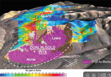
Deposit map for the Donlin gold project shows future exploration and
resource-expansion targets. (Courtesy of NovaGold)
Donlin Project Reaches Permitting Milestone
Donlin Gold LLC, jointly owned by Barrick and NovaGold, has applied for permits to develop an open-pit, hard rock gold mine. The project would take about three to four years to construct. Mine life is estimated at 27.5 years, producing approximately 1 million oz/y of gold. The processing facility would have throughput capacity of about 59,000 st/d.
If developed, the Donlin project would be based on a subsurface lease with Calista Corp., an Alaska Native regional corporation, and a surface use agreement with Kuskokwim Corp., a merged Alaska native village corporation. Some project components would be on state of Alaska and U.S. Bureau of Land Management lands.
The mine and facilities would have a total footprint of about 16,300 acres. The open pit would ultimately be about 2.2 miles long, 1 mile wide, and 1,850 ft deep. A tailings impoundment would ultimately cover about 2,350 acres, while a waste rock facility would cover approximately 2,300 acres.
A proposed barge landing on the Kuskokwim river would be a key piece of transportation infrastructure, which would also include a 30-mi road from the mine site to the barge landing, a 5,000-ft airstrip, and upgraded dock facilities at the shipping port of Bethel. A proposed 315- mi pipeline would bring natural gas to a proposed on-site power plant.
The Corps has a dedicated website for its Donlin projects DEIS at www.donlingoldeis. com.