
An SSR radar scanning system installed at one of PT Adaro’s surface coal operations in Indonesia. (Photo courtesy of GroundProbe)
Careful Monitoring: The Key to Pit-wall Safety
As mines get deeper, and economic
pressures provide an incentive for
steeper pit walls, the potential for
instability increases. E&MJ looks at some
of the systems that can help mine engineers
keep an eye out for signs that all may not be
well within the wall.
By Simon Walker, European Editor
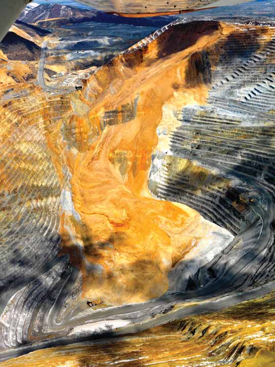
Speaking a few days later when pre-senting the company’s first-quarter oper-ational review, CEO Sam Walsh expanded a little on the effect that this may have on Rio Tinto’s copper production for the rest of this year. “At Bingham Canyon, last week’s pit-wall slide will have a sig-nificant impact on our copper production this year,” he said. “A recovery plan is being implemented to minimize the eco-nomic impact.
“Based on an early assessment of information currently available, it is esti-mated that 2013 refined copper produc-tion at Kennecott Utah Copper will be approximately 100,000 metric tons (mt) less than previously anticipated,” he said. To put this into context, during 2012 Bingham Canyon contributed 163,200 mt to the company’s total of 548,800 mt of mined copper, and 162,700 mt of refined copper.
Early estimates suggested that around 150 million mt of material slid into the pit. The most important outcome of the incident, of course, was that no one was injured. The material damage, however, was significant, with the principal access ramp out of the pit now unusable in the area of the slide. In addition, three of the mine’s 13 shovels were damaged, as were 14 of its 100-truck haulage fleet and some ancillary equipment.
Imagine, though, the impact had there been no monitoring procedures in place, and the company was unaware of the increasing instability in this section of the mine. The consequences could indeed have been catastrophic.
And, to be fair, today’s sophisticated monitoring systems are a relatively new addition to the mine engineer’s toolkit. Until high-sensitivity radar, surveying and laser systems became available for this market sector only a few years ago, pit-wall inspection was essentially a visual exercise, requiring personnel access into potentially hazardous wall areas to enable detailed assessment to be carried out.
Radar Systems Provide
Long-range Accuracy
After the slide, Rio Tinto was quick to
issue a fact sheet that explained in some
detail the various systems used at
Bingham Canyon to monitor the walls of
the 1,200-m-deep pit. “Our monitoring
system includes the trained eyes of more
than 800 employees, regular document-ed inspections of all areas of mining
activity by geotechnical engineers, and state-of-the-art equipment,” the compa-ny noted.
Bingham Canyon uses GroundProbe and IBIS slope-stability radars, extenso-meters, robotic theodolites, time-domain reflectometry and microseismic monitor-ing, all of which feed data to the mine’s geotechnical department to help improve understanding of how the pit walls are reacting to continuing excavation of ore and waste rock.
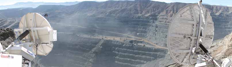
According to Australia-based Ground-Probe, the concept of using radar to meas-ure pit-wall movements began as a University of Queensland research pro-ject in 1997. The company launched its Slope Stability Radar (SSR) system in 2001, and more than 150 units have since been put to work in 20 countries, with more than 500 wall failures detected.
Mounted on a four-wheel trailer, an SSR unit monitors a pit wall from the opposite side of the mine, scanning the entire face in repeated cycles. With a 900-mm-diameter dish, the system has a range of between 30 and 1,400 m, while using a 1,800-mm dish increases this to 3,500 m. At this range, the com-pany said, a unit can detect a failure measuring 30.5 m (100 ft) square, even in operations where there is high humid-ity or rainfall.
GroundProbe said its advanced analy-sis tools allow for long-term trending and hazard identification, while photographs of the scan area allow user-friendly iden-tification and interpretation of slope movements. The system will also recall previously stored data if a unit has to be moved temporarily and, most important-ly, it will raise an alarm if it detects accelerated slope movement that can be a precursor to wall failure.
While SSR is designed to operate as a broad area monitoring system, continu-ously collecting data over time and pro-viding high-precision data, sophisticated trending information and advanced alarm capabilities, GroundProbe’s Work Area Monitor (WAM) is used to warn work crews of wall movement using visual and audible alerts. Its range and slope cover-age make it ideal for applications close to the wall, the company claims, noting that the two systems have distinct, but highly complementary applications and that for the ultimate solution in slope stability monitoring, its clients use both.
As well as being able to monitor pit walls for purely safety reasons, the com-pany pointed out that its systems can also help producers to optimize their resource utilization. In one example, it said that Indonesia’s PT Bayan was able to recover coal worth perhaps up to $8 million by monitoring potentially unstable pit wall and floor areas, relying on real-time movement data to schedule its mining sequence.
A division of Reutech Radar Systems, the South African company that develops and manufactures ground and naval radar systems, Reutech Mining services the open-pit mining industry with its MSR movement and surveying radar. The company offers three versions of its sys-tem, the MSR 200, 300 and 060.
Reutech has reported on the use of one of its MSR200 units at Codelco’s Andina operation in 2008. During the first 15 days of monitoring a suspect area of pit wall at a distance of 575 m, very little movement was noted. However, a sudden increase in movement was then identified, with subsequent acceleration leading to the final wall slide some 30 minutes later. The ability to use the sys-tem to provide a warning of the impend-ing collapse allowed the mine to with-draw personnel and equipment in time.
Last year, E&MJcited another appli-cation of Reutech’s system at Eldorado Gold’s Kişladağ mine in Turkey (May 2012, pp. 28-32). Localized failures had occurred along sections of the pit wall, so the MSR system provides close monitor-ing, taking between 5 and 10 minutes to complete a scanning cycle across the entire opposite wall.
According to Reutech, the MSR pro-vides real-time, all-weather surveying and slope movement measurements using state-of-the-art radar and surveying tech-nology. Real-time capabilities are given by its ability to carry out stability and survey-ing measurements simultaneously, with data being exported via high-speed links. The system uses not only radar but also an integrated Leica Geosystems total sta-tion. Maximum distances for the units are 1,200 m for the MSR200 and 2,500 m for the 1,200-mm-dish MSR300, with the company claiming that the MSR 300 is the only slope radar system currently available that can resolve a 15 m bench failure at 2,500 m.
Meanwhile, the MSR060 is a modular version of the equipment that can be fit-ted into the back of a pickup for greater maneuverability. In each case, the sys-tems are capable of detecting sub-milli-metric movements on the slopes being monitored, with measurements being fully geo-referenced to an accuracy that allows for seamless integration with stan-dard digital terrain mapping tools.
As an alternative to dish-type sys-tems, Italian-domiciled IDS Corp. offers interferometric mine slope radars. Its IBIS-FM provides sub-millimetric meas-urement capabilities at distances of up to 4,000 m, IDS said, with just two-and-a-half minutes needed to complete a full resolution scan from 2,000 m. A number of these units, either fixed or mobile, can be linked around the perimeter of a pit to form an FPM360 system—which in turn can provide complete coverage of all the pit walls in real time. The company point-ed out that each system is custom-designed to meet an operation’s specific needs, and can be scaled to accommo-date future pit expansions.
Speedy Laser Scanning
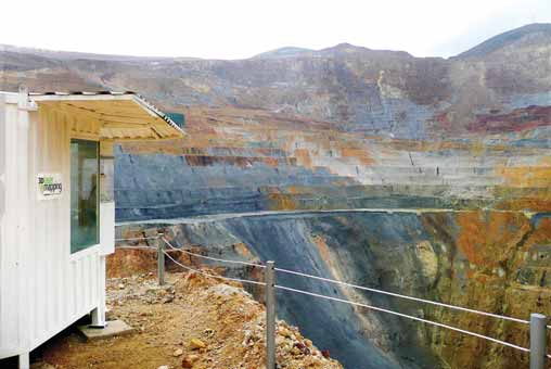
In the U.K., 3-D Laser Mapping has been
one of the pioneers in the use of Lidar
systems for monitoring open-pit mines.
Development of its SiteMonitor system
was driven by the need for a mapping and
monitoring solution that takes full advan-tage of the benefits of laser scanning
while remaining easy to use, the company pointed out.
A state-of-the-art laser measurement-based system for monitoring rock faces and landslips, SiteMonitor was developed in partnership with mining surveyors to provide a simple-to-use, reliable and flexi-ble solution. Using non-contact laser hard-ware, the system makes range measure-ments on a pre-defined grid on a selected cycle, with a software suite that incorporates an analysis module for displaying and analyzing time-series monitoring data.
According to 3-D Laser Mapping, Site-Monitor’s key advantages include the fact that no prisms have to be placed in the sur-vey area, with the system providing rapid monitoring of thousands of points rather than single prism locations. It gives com-plete coverage of the visible surface, with a measurement range of up to 6,000 m. It is also portable, so it can be set up in areas where access is limited.
Slope stability monitoring is just one of the tasks now being given to a Riegl VZ 1000 laser scanner that the company recently supplied to Exxaro Resources for use at its Grootegeluk coal mine in South Africa. In addition, the equipment is being used to survey stockpiles for vol-ume verification, provide height analysis on earthworks and blasting, and to col-lect highly accurate measurements for terrain mapping and modeling.
The mine’s chief surveyor, Thys Smith, noted that the system “allows us to man-age risk, minimizing surveyor contact with moving equipment and potential falls of ground. The work we do includes bench surveying, volume verification, height analysis, as-built surveys, terrain mapping and modeling, and ground control and contouring,” he said.
3-D Laser Mapping describes the Riegl VZ 1000 as a high-speed laser scanner with a wide range of view that utilizes unique echo digitization and online waveform analysis to achieve superior performance and accuracies of measurement, even under adverse weath-er conditions. Achieving accuracies of 5 mm at ranges of up to 1,400 m, it can measure up to 122,000 points per sec-ond with a 100 × 360° field of view.
Also British-based, Measurement De-vices Ltd. (MDL) has been supplying laser-based, time-of-flight measurement systems to users in the mining, quarrying and other industries since 1983. Its Quarryman Pro mining-industry laser pro-filing system is now used by most major surface mining and quarry service compa-nies worldwide, according to the company.
The company recently introduced a long-range version of the system, the Quarryman Pro LR, which can measure at ranges of up to 1,200 m to nonreflective surfaces and also has a vertical spot size approximately 10 times smaller than its predecessor. The increase in range and smaller spot size allows the operator to collect more detail at longer ranges, thus minimizing equipment set-ups and time on station.
Designed for operation from a stan-dard surveying tripod, the unit weighs just 8.1 kg (18 lb). It has a 250-point-per-second scan rate in automated mode, or can be used as a point-and-shoot sys-tem in manual mode. Data are recorded to compact flash cards for later process-ing using either MDL or other industry software to give 3-D face profiles that can be compared over time to identify areas of potential instability.
Total Stations are
Another Option
Conventional pit-wall monitoring has
relied on visual inspection, often sup-ported by detailed surveying, to generate
a record over time. There is no question
that this approach still has a valuable
role to play, and the development of lat-est-generation total stations has helped
to maintain its position in this respect.
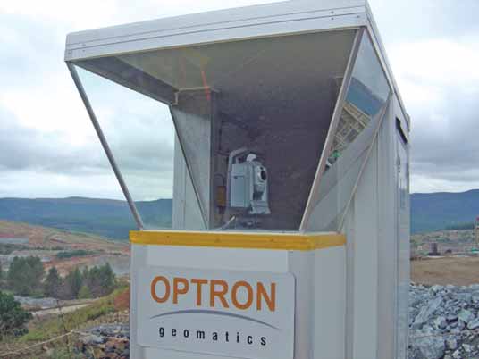
As an example, Switzerland-based Leica Geosystems reported that its spe-cialist surveying equipment has been in use at one of PT Adaro’s coal operations in Kalimantan, Indonesia, since 2004. Here, the company said, 11 Leica Geosystems’ total stations are installed at the Tutupan mine, with hundreds of monitoring prisms on the pit slopes pro-viding the means for carrying out slope-stability monitoring.
The prisms are installed on the pit-wall surfaces at 100–150 m intervals, with the total stations measuring dis-tances of 800–2,500 m in a nearly con-tinuous cycle. There are also six meteor-ological sensors within the mine that automatically measure the atmospheric conditions. All of the data gathered are transmitted by radio link to a Leica GeoMoS control system, with software used to generate long-term deformation information. Leica noted that since the monitoring system has been installed, the geodetic and geotechnical sensors controlled by the monitoring software have been able to detect some slope fail-ures in advance, with other techniques such as inclinometers, crack-meters and visual inspections adding to the informa-tion resource.
In Poland, meanwhile, a Leica Geo-systems’ slope monitoring system has been in use at the Bełchatów lignite mine for the past four years. Comprising two total stations and a global navigational satellite system (GNSS) reference net-work to known stable points, and also controlled by GeoMoS software, the sys-tem provides the mine operator with slope-stability displacement data in a local coordinate system. One of the total stations works continuously and is mounted inside an air-conditioned con-tainer, equipped with a hydraulic leveling system. Both units measure continuously more than 50 monitoring points located on the pit walls around them.
Not all stability issues arise in open pits, of course, and the company has supplied the Polish copper producer, KGHM, with a monitoring system for a section of its huge Zelazny Most tailings dam near Lubin in the west of the coun-try. Having relied on traditional monitor-ing techniques for decades, in 2008 KGHM began using a Leica Geosystems total station and prisms, with data being sent for processing and interpretation via LAN and WiFi links. Leica Geosystems said its monitoring solution, which includes the SyZeM geological software, has helped give a major improvement in generating and analyzing data, with slope-failure predictions now being done in real time.
U.S. company Trimble’s 4D Control is an automated monitoring system used in real-time slope-stability monitoring. It processes and stores data from optical, GNSS, geotechnical sensors and weather stations, which are then are visualized, analyzed, alarmed and reported via a powerful, user-friendly web interface.
Trimble said the heart of the system is its S8 total station, capable of measuring up to 2,500 m with a precision of better than 1 mm in distance and 1 arc second in bearing. It includes several industry-leading technologies that contribute to meeting the demands of slope stability monitoring including frictionless Mag-Drive servo technology for faster meas-urement and FineLock technology for flexibility in proximity and density of prism targets. The network of total sta-tions, reference prisms and monitoring prisms is augmented with NetR9 GNSS reference receivers. These receivers may be used as independent displacement sensors or may be combined with refer-ence prisms and total stations located in potentially unstable areas to provide updated locations during a combined adjustment process.
The company notes that 4D Control supports a broad variety of geotechnical and meteorological sensors. For example, Trimble REF TEK accelerometers can be used to monitor the magnitude of blast shock waves on high walls and surround-ing infrastructure, since their effects can result in vibrational stress fracturing of the rock mass, ultimately leading to rock-falls or more complex failures.
Data from all instruments and sen-sors are processed by the server compo-nent of the software, and are stored in a unified monitoring database for subse-quent visualization or complex compara-tive analysis. Velocity and inverse veloc-ity facilities are available for highwall stability monitoring, addressing the challenges of both slow and accelerated movements, which are one of the indica-tors of a potential failure.
Alarms may be configured on data from any combination of GNSS, optical, geotechnical or weather sensors. Various levels of alarm can be set and the current status of the system can be viewed on the web interface in real time.
Trimble states that the combination of GNSS sensors, prisms and the angular accuracy of the total station are suitable for the detection of both toppling and slumping failures on a highwall. Suitable placement of prisms across a suspected fault line, combined with a dedicated com-putational feature on the 4D Control soft-ware, enables the prisms to simulate a wire extensometer, so differential movement between adjacent rock masses can be monitored with a high level of accuracy.
Trimble offers several technologies to provide terrain mapping and volumetric measurements, including unmanned aeri-al systems and spatial imaging systems, that can be used in slope failure analysis. Its Gatewing X100 is an unmanned aerial system used for fast and accurate map-ping and analysis of hard-to-reach and hazardous areas, while the VX spatial sta-tion integrates optical surveying, metric imaging and 3-D-scanning technologies for precise measurement at ranges up to 5,500 m in long-range mode.
With an Ear to the Ground
Microseismic monitoring is used in open-pit mines to monitor the rockmass
behind pit walls in order to detect behav-ior that may cause slope instability at the surface. As the Canadian equipment sup-plier ESG Solutions pointed out, seismic-ity behind a pit wall may be caused by a
number of factors, but in all cases knowl-edge of the location of microseismic
events can help operators plan mine
development and mitigate risk.
The primary applications for microseis-mic slope monitoring include the evalua-tion of fractures generated during mining applications, activation of known or unknown geological structures in the rock mass, stress changes behind the slopes and evaluation of vibration thresholds of the slope structure. A microseismic system determines the location and magnitude of seismicity in real time, potentially acting as an early-warning system by detecting abnormal seismic activity weeks before displacements are observed at the surface.
The company explained that as in-situ stresses change in the rock mass during open-pit operations, rock failure in the form of cracks or fractures is common. Some fractures may propagate to the pit walls, while the removal of large volumes of rock during mining may release or reduce in-situ stresses, enabling move-ment along natural faults or joints.
Sensitive monitoring equipment is deployed in an array around the zone of interest to “listen” to the sounds of rock as it cracks and fractures. Seismic ener-gy released in the form of waves can be detected by the sensor array. The origin or source of the “event” can then be located and mapped in 4-D (x, y, z + time). Sensor arrays consisting of uniaxi-al and triaxial 15 Hz geophones are designed to provide good coverage of the monitoring zone, with most open-pit monitoring systems relying on sensors deployed from the surface.
Seismic signals picked up by the array are transmitted to Paladin acquisi-tion units, then on for processing using ESG’s Hyperion Seismic Software (HSS) suite to determine the size of each event as well as its location in 3-D. The soft-ware is used to visualize results with respect to the slope geometry for a greater understanding of rock-mass behavior behind the slope wall, with data from inclinometers and other instru-ments also being used to detect varia-tions in tilt or surface deformation con-sistent with slope instability.
ESG said one application for its equipment involved a 36-channel micro-seismic array consisting of nine triaxial and nine uniaxial 15 Hz omni-directional geophones to investigate slope instability in a large open-pit mine in South America. Over a four-month period, close to 1,000 microseismic events were de-tected to a positional accuracy of 28 m. Evaluation of this seismicity revealed that mining operations had activated local geological structures, with the majority of the seismicity occurring along two trends behind and parallel to the eastern wall of the pit. The mine operator was able to integrate this knowledge into its planning activities to help mitigate the risk of subsequent instability.
Aerial Imaging:
The UAVs Arrive
As noted in the article on digital solu-tions for mine mapping in the January edition of E&MJ (pp. 40-43), mining
companies are increasingly making use
of unmanned aerial vehicles (UAVs)—or
microdrones—to undertake photographic
surveying that can then form the basis for
highly detailed topographical imagery.
The article cited the Gateway X100 UAV
from Trimble, although this is just one of
many competitive models now available.
The major benefits of this type of equip-ment is that they are light-weight, simple
to use, and can be programmed to fly a
specific path, at a stipulated elevation,
over areas that would take days to survey
or photograph manually.
Thus far, UAV use has typically been restricted to tasks such as mine, stock-pile or waste dump overviews, rather than carrying out the high-precision surveys needed to monitor pit walls. However, as the CEO of the Swiss software company Pix4D, Dr. Christoph Strecha, noted, there is no technical reason why this should remain the case. “We can already do oblique 3-D-modeling up to a very high resolution,” he said.
Dr. Strecha explained that the accu-racy achieved depends largely on the elevation at which the UAV flies above the surface being scanned. “For a UAV flying at 50 m, he said, each image pixel represents about 20 mm. Fly nearer the surface, and you can reduce this to about 5 mm. The closer the UAV is to the surface, the more images are taken to cover a specific area, the longer it takes and the better the accuracy—so it’s a trade-off between the time taken to do the survey and the number of images,” he said.
“The technology for processing image data like this has only been around for less than 10 years, but already some of the major mining companies are keen to make use of it to carry out regular in-spections on site while the UAV is con-trolled remotely from the survey office— which could be somewhere else com-pletely. What it can’t do yet is provide real-time data; for that you still need to have radar or some other similar sys-tem,” Dr. Strecha said.
As Andrew Blogg of the British com-pany, Digital Mapping & Survey, pointed out, stability monitoring is indeed possi-ble using UAVs. The company is current-ly working on an iron ore development project in West Africa where, he said, the operating company is actively evaluating their use to monitor steep, inaccessible spoil piles formed during the construction of railway lines.
The bottom line is that pit-wall failures can be very costly indeed in terms of lost production, equipment and infrastructure damage, and in the potential risk to per-sonal safety. Monitoring technology has come a long way in a relatively short time, with mining companies realizing real bene-fits from using combinations of systems to get a better understanding of what is really happening out of sight, behind the pit wall.
The Bingham Canyon slide has demon-strated just how effective monitoring has become, and perhaps one comment on the operation’s Facebook page summed up its success on a personal level. “You guys did a great job,” said Jennifer Loder Heaps. “My husband was working last night. Thanks for getting him home safe!”