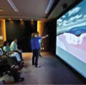
Vale is using a Virtalis ActiveWall visualization system, shown
here, for project planning and engineering analysis.
New Generation of 3-D Mining Software Sets the Scene
Interactive, immersive 3-D display systems, high-performance cloud computing and robust data management tools contribute to miners’ greater understanding of what lies beneath the surface
By Russell A. Carter, Managing Editor
In Mexico, a Canadian mining company with one working gold mine and an advanced gold project, as well as other exploration assets, doesn’t have enough skilled technical personnel to staff several separate locations. Goldgroup Mining, owner of the Cerro Colorado mine in north-ern Sonora and the Caballo Blanco project north of Veracruz, uses Gemcom’s Hub to efficiently transfer data between sites, maintain version control and maximize the time and resources of its limited staff.
And now, mineral explorers with a need to analyze geophysical data derived from airborne or ground-based gravity and mag-netic surveys now can look to the ‘cloud’ for 3-D visualization of what lies deep under the earth, reducing the workload on in-house computers and the possible need to buy additional computing power.
Dating back from the dawn of the PC era in the early 1980s up to present-day focus on tablets, ruggedized laptops and highly capable smartphones, software has found countless uses in all aspects of min-ing. For an industry stretched to its limits by manpower shortages, project develop-ment in increasingly remote locations, and a rapidly growing need to collect, organize, transfer and analyze massive amounts of data to and from distant sites, software solutions are an indispensible tool for mod-ern mine planning, development and oper-ation. Here are just a few examples of what’s available, and how it’s being used.
Up Against the ActiveWall
Vale, the world’s second largest mining
company, has adopted GeoVisionary soft-ware and installed a portfolio of Virtalis
ActiveWorks 3-D visualization systems.
Headquartered in Brazil, Vale operates in
38 countries and directly employs more
than 126,000 people, as well as another
50,000 working on ongoing projects.
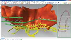
GeoVisionary was developed by Virtalis, in collaboration with the British Geological Survey, as specialist software for the high-resolution visualization of elevation and photography data overlaid with a wide range of geospatial data. The initial design goal was to ensure that data sets for large regions, national to sub-continental, could be loaded simultaneously and at full reso-lution, while allowing real-time interaction with the data.
According to Virtalis, one of the major advantages GeoVisionary offers over other visualization software is its ability to inte-grate very large volumes of data from mul-tiple sources, allowing a greater under-standing of diverse spatial data sets.
Vale’s ActiveWall draws on active stereo technology and features a custom rear-pro-jection screen, specialist computer, Virtalis custom software and a powerful projector. Movements within the ActiveWall environ-ment are tracked; this added functionality alters the perspective of the visuals accord-ing to the user’s position and orientation within the scene to give a natural and accurate sense of relationship and scale. A handheld controller allows the immersive experience to be enhanced further. The user can navigate through the virtual world, pick and manipulate component parts in real-time and make decisions on the fly.
Henry Galbiatti, Vale’s general manager for iron ore exploration, closed mines and manganese planning, explained: “We con-stantly have new projects in the pipeline aimed at helping Vale increase production, retain market share and maintain ore qual-ity, so, naturally, long-term planning is cru-cial if we are to successfully bring our plans to fruition. The nature of our business is such that visualization is vital. When I vis-ited the British Geological Survey’s Active-Wall and also Northampton University’s ActiveCube, I saw at once that GeoVisionary running in a Virtual Reality environment was exactly what we were looking for.”
Vale also has acquired a portable ActiveMove system and a multi-screen desktop VR system. The company is using GeoVisionary not only for exploration and mine management, but also as an environ-ment for staff training.
Galbiatti said GeoVisionary currently is being used on two major projects, “And then we hope to use the software on all our pipeline projects to help with mining, engineering and environmental matters. Already, we are finding that being able to see more data and having it in 3-D, we can visualize weaknesses and strengths within our projects much more easily and then act to make corrections faster. Once GeoVision-ary is being routinely used, we’ll have to expand our hardware facilities too, so we are considering adding an ActiveCube, but we are moving one step at a time.”
Counting on the Cloud
Geosoft, a Toronto, Canada-based company
that provides software for mapping and
modeling the Earth’s subsurface, and tech-nology for managing large exploration data
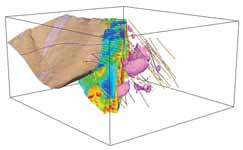
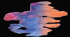
sets, has released VOXI Earth Modeling,
described as a cloud-based geophysical
inversion software service that generates
3-D voxel models from airborne or ground
gravity and magnetic data. VOXI is avail-able as part of the Geosoft 2012 software
release.
As noted by Geosoft, over the past decade 3-D geophysical modeling has become increasingly important to mineral exploration. The ability to convert geophys-ical measurements directly into 3-D images of subsurface rock properties that can be integrated with other exploration information in three dimensions enables resource explorers to extract significantly more insight from geophysical data.
“One of the important benefits of con-verting gravity or magnetic data into a 3-D earth model is that the visual end product allows explorers to see and understand the subsurface using now common 3-D view-ing platforms,“ said Ian MacLeod, Geosoft chief technologist. “VOXI produces a model of rock properties, which can be directly integrated with other surface and subsurface geologic observations. "
“We’ve designed VOXI Earth Modeling to fit naturally within an explorer’s work-flow, and we’ve made it fast, recognizing that speed in generating 3-D inversions is a critical requirement that will allow geo-scientists to use this tool routinely,” said Robert Ellis, Geosoft senior earth modeling scientist.
VOXI Earth Modeling, offered as a soft-ware service extension accessible within Geosoft Oasis montaj, is powered by cloud technology engineered by Geosoft to speedily conduct complex geo-computing using powerful cloud server farms, with minimal drain on the customer’s own com-puter systems.
How it’s Used
Although 3-D visualization is becoming
increasingly in demand—particularly from
a new generation of engineers and planners
used to viewing graphical displays of
almost everything—the more mundane
mechanics involved in collecting, organiz-ing and transferring huge data sets is
another software-system capability that’s
quickly reaching mandatory status.
Gemcom Software, which claims to be
the largest global supplier of mining soft-ware solutions, with more than 4,000 sites
using its software and customers in over
130 countries, has eight principal software
packages that variously support exploration,
mine planning, optimization and strategic
mine planning, scheduling, mine produc-tion management, data management, and
more. Its software includes the geology and
mine planning packages Gemcom Surpac
and Gemcom GEMS. While many of its
products, such as Surpac, offer sophisticat-ed 3-D visualization tools—and the com-pany was, in fact, recently acquired by
Dassault Systèmes, a specialist in 3-D
design and visualization systems—Gem-com also has introduced some significant
advances in mine planning, scheduling and
data management products.
Mark Bese, Gemcom’s marketing man-ager, provided E&MJwith several examples of how the company’s products are used in common, but distinctly different, mining applications. For example, Tiger Resources’ Kipoi project, located in the Democratic Republic of the Congo, uses Gemcom Surpac for many functions throughout its open pit copper operation including block modeling, creation of dig blocks, monthly reconciliation, geological mapping, mine planning, and civil works. Where Surpac has been most beneficial to the operation, said Bese, is with grade control.
Rhonny Kazembe, chief mine geologist for Kipoi, described how Surpac has helped, “By using Surpac’s grade control results, we can locate ore according to grade category which allows us to maximize ore recovery while minimizing dilution. The final concentrate results clearly demon-strate that Surpac has improved our sepa-ration of high grade ore from low grade ore. Our customers have been very happy with the quality of our copper concentrate.”
Gold Fields Ghana’s Tarkwa gold mine also benefits from Surpac, using it in con-junction with Gemcom Whittle. With Whittle, the operation generates and selects the standard optimal pit shells from which they calculate their reserves, then exports the pit shells to Surpac to develop schedul-ing designs. Whittle has enabled them to rapidly generate multiple scenarios, and the minimum mining width feature has helped them create an improvement in cash flow through the scheduling of internal cutbacks.
The mine’s Chief Strategic Planning Engineer, Lucette Hugo, said, “Whittle allowed us to find scenarios that showed a clear improvement over the base cash flow and also to see where production targets may be reducing cash flow. We were able to quick-ly select and re-evaluate internal cutbacks.”
Samarco has been using Gemcom GEMS for more than a decade to support their open pit iron ore mining in Brazil. Samarco relies on GEMS for its data man-agement capabilities, allowing the operation to better organize all of their different proj-ects, survey, geology, and planning data into one central location, improving collabora-tion between users. Mine Planning Super-intendent Luiz Eduardo Resende said, “With the updated technology it became possible for our geologists to work simulta-neously on the same project information without risking data corruption. Accurate data models are key to our success, and by implementing the software we have been able to achieve greater security and reliabil-ity of our research and survey data.”
Because mining often occurs in remote locations, Gemcom has developed Gemcom Hub, a secure remote collaboration solution that enables mining professionals to work with and more easily share data regardless of where they are located in the world. It does this, according to Gemcom, by over-coming the challenges posed by poor qual-ity, intermittent network connections with patent-pending technology that detects and transmits only the particular elements of the file that have changed. Whereas tradi-tional transfer methods require an entire file to be transferred if the file has been updated, perhaps a block model that is gigabytes in size, Hub does not, sending only the data which has changed, which may only be kilobytes instead.
As mentioned in the introduction, Goldgroup Mining has employed the sys-tem to help them address challenges posed by not having enough skilled technicians to staff four different mine and project sites scattered across Mexico. By applying Gemcom Hub, Goldgroup was able to cen-tralize data, overcome limitations of a low-bandwidth network thanks to rapid upload/download of data (only changes to files are transmitted), and secure, backup, and apply version control to data. Benefits achieved include transparency into opera-tions at the four sites, centralization of lim-ited staff to work on projects, and visibility across projects for senior managers.
Doing More with 64
Software system suppliers also are busily
updating their flagship products to take
advantage of 64-bit processors and operat-ing systems. A 64-bit version of a program
can dramatically improve performance over
32-bit versions in handling the large data
arrays that are becoming commonplace in
mining.
Maptek launched the 64-bit version of its Vulcan 3-D mining-software suite in April. “The handling of larger data sets has been a number one client request for some time,” said Eric Gonzalez, Vulcan product manager. “Benchmarking conducted in-house shows massive step-wise improve-ments in loading large data sets compared to 32-bit. This was supported by user expe-rience, reported from the global 64-bit beta testing program run in the lead up to the release.”
Both 32- and 64-bit versions are shipped simultaneously under Vulcan 8.1.4. Data are compatible between plat-forms, allowing users running 8.1.4 32-bit to share data and projects seamlessly with 64-bit user colleagues. Vulcan 8.1.4 includes new options for resource model-ing and short term planner tools, along with composited models for stratigraphic deposits, stripping ratio tools for strati-graphic models and improved grade shells. The recently released Version 5 of Mintec’s MineSight Schedule Optimizer also incorporates 64-bit technology for faster processing power, and now allows planners to schedule bigger cuts and par-tial (percentage) cuts.
“Mining partial percentage cuts allows you to split a cut into multiple scheduling periods,” said Mintec Vice President Glenn Wylde. “So if a percentage of a cut is enough to achieve the target for a period, then the remaining percentage of this cut can be carried over to the next period.
“Depending on how detailed the sched-uling is, a planner may want to design big-ger cuts, which will save space, memory and run time. Version 5 offers the ability to split bigger cuts into multiple periods. For long-term and medium-term planning, you have the option of using bench reserves, in which an entire bench will be cut.
“Occasionally, mining operations are conducted on multiple benches simultane-ously,” Wylde said. “In this case, a bench can be mined partially as long as the upper bench has opened up enough space for equipment and crew. Partial cut mining is essential in calendar-based scheduling.”