The topic of mine planning has bubbled
to the surface recently on Internet mining
discussion groups. There’s one major
theme, surrounded by a galaxy of related
questions: Is mine planning—specifical-ly, long-term planning—a dying art,
squelched by industry-wide focus on
short-term results? Associated questions
range from ‘Does long-term planning
receive adequate management support?’
and ‘Does faster management turnover at
the operational level risk short-circuiting
any long-term plans in place?’ to ‘Should
the same personnel be responsible for
both short-term and long-term planning?’
and ‘Are planners being overwhelmed by
floods of raw exploration and operational
data, and do they have the time,
resources or training to separate the
wheat from the chaff?’
A brief example of how misapplication
or misinterpretation of data can cost a
mine is offered by software and services
supplier Ventyx (formerly Mincom,
recently acquired by ABB): Under-estimating coal thickness by 6 in. (152
mm) over an area as small as 11 acres
(4.45 ha) will result in a planned pro-duction shortfall of one unit train. If coal
is selling at $50/ton, that’s $500,000 of
revenue lost by the mine.
Bill Wilkinson, Ventyx’s product man-ager for MineScape, recently addressed
the formidable problem of staying afloat
in the rough waters of current mine-plan-ning demands in a paper titled Top Five
Challenges in Mine Planning . According
to Wilkinson: “Geologists and mining
engineers must account for a staggering
array of variables—geological samples
and data from the mine, the production
capacity of available equipment, machin-ery and manpower availability, customer
demand and commodity prices, product
cost assumptions, and the health and
safety of workers.
“Traditionally, the time and resources
required to continually collect this data
meant that no one could keep pace with
the reality of what’s happening at the
mine site. Furthermore, the process of
developing mine plans may utilize dis-parate systems, which introduces ineffi-ciencies in the process and more oppor-tunity for error. Additionally, inefficien-cies can be introduced by the technology
being employed, especially for geologi-cally complex areas and where large
amounts of data are being modeled.”
His ‘top five’ challenges include:
• Capturing the true complexity of miner-al deposits
Geological models gener-ated for initial feasibility studies are
often not detailed enough to provide an
accurate picture of a mine suitable for
creating detailed production plans—
and the software used to develop mod-els in a feasibility study may not be suit-able for the production environment.
• Updating mine plans with new data
from the field
Mine planning and
scheduling has traditionally been such
a time-consuming, labor-intensive pro-cess that it prohibits the timely genera-tion of new or updated plans as quick-ly as new data is received. This is com-pounded by staff turnover and a short-age of skilled mine planners and geolo-gists to execute planning.
• Generating accurate production and
budget forecasts
Managing natural
variations in an orebody is extremely
difficult, often leading to educated
guesses and “fudge” factors based on
past experience. Process inefficiencies
and technology deficiencies delay or pro-hibit the inclusion of the latest mine data
into the geological models and mine
plans in time to stay ahead of operations.
• Capitalizing on quick changing market
and operational conditions
Because
of the length of time required to per-form some of the geological modeling
and mine planning tasks, planning frequency may not be keeping pace with
the frequency of change. Mine plans
and schedules are difficult to adapt to
the changing conditions of a company’s
resources, such as its people, plant or
equipment.
• Streamlining the flow of information
between the geological modeling, mine
planning and mine scheduling process-es
If mine planning and scheduling
are not run from a single integrated sys-tem, geological and mine planning and
scheduling data must be moved and re-entered, increasing the likelihood of
introducing errors and decreasing mine
planning turnaround time.
In the final analysis, the right mix of
short- and long-term planning is a thorny
matter, hard to resolve because it
involves so many separate facets of an
operation’s structure. Concerning one
related issue, though, there is no ambi-guity: Software developers and ‘solutions
providers’ are providing a steady flow of
new or upgraded tools claimed to make
data handling and analysis, production
control and planning easier, with more
meaningful results.
A quick scan of recent product-implementation announcements, as fol-lows, provides a glimpse of how compa-nies are employing these products
in all phases of the exploration/develop-ment/mining sequence to meet their
specific data management and reporting
demands.
High-speed Core Scanning
All planning is based on data collection
and interpretation, and the quicker these
two phases are accomplished, the more
time available for formulating valid plans
and schedules. A new imaging tool devel-oped by a small Quebec, Canada-based
company is claimed to allow drill core
analysis to proceed at higher levels of
speed and accuracy. An interesting side
note is that, in most cases, the latest
data collection-and-analysis upgrades
and innovations offered to the industry
are based on the latest programming and
hardware technology; in this example,
however, the application traces its roots
back to 1960s-era science.
Photonic Knowledge says its Core
Mapper hyperspectral imaging applica-tion is a derivative of technology original-ly developed 50 years ago for remote
sensing from aircraft and satellites that
captures and analyzes information from
across the entire electromagnetic spec-trum. Much as the human eye sees light
in three bands (red, green and blue),
spectral imaging divides the spectrum
into many more bands—and Core Mapper
adapts this technology for use at drill-core scale with significantly higher reso-lution. The wavelength differences of
absorbed and reflected light from core
samples is analyzed in hundreds of very
narrow bands down to a resolution of 2
nanometers, or 2 billionths of a meter of
the visible and near infrared light spec-trum. This technological application has
a spatial precision of one square millime-ter, much greater than a square meter as
usually found in remote sensing.
According to Photonic Knowledge
President Eric Roberge, two junior com-panies—Northern Gold Mining Inc. and
Armistice Resources Corp.—recently be-gun using Core Mapper in their drilling
programs.
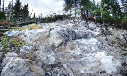 Northern Gold Mining, a Canadian junior company, has applied Photonic Knowledge’s Core Mapper
hyperspectral imaging technology to achieve quicker analysis of core samples taken from the company’s
Garrison gold property, where mineral-ization occurs primarily as native gold in in stockwork quartz
carbonate veins, as shown here.
Northern Gold Mining has retained
Photonic Knowledge to provide and oper-ate the Core Mapper technology to
enhance the determination of mineral and
metal content in drill core samples from
Northern Gold’s Garrison gold property, 90
km east of Timmins, Ontario. Near-term,
NGM plans to use Core Mapper to analyze
approximately 100,000 m of drill core
from previous operators on the property
with the expectation that several hundred
thousand meters of past, current and
future core drilling, and possibly includ-ing reverse circulation drill cuttings, will
be mapped using the technology.
Armistice, moving forward to begin
production at its McGarry gold mine in
the Kirkland Lake area of northeastern
Ontario, entered into a long-term service
agreement with Photonic Knowledge fol-lowing an extensive evaluation process
over the past year; the application will
involve scanning of about 6,100 m of
new and historic core.
Armistice expects the technology to
allow it to obtain an understanding of the
mineralogy and hydrothermal alteration
facies associated with historical re-sources more quickly and efficiently than
with the visual method normally used by
Armistice.
Also, in this structure of highly altered
volcanics, Armistice believes the new technology will allow it to better under-stand the mineralized system of the
prospective area, specifically, the two
types of gold-bearing environments with-in the alteration zone: green carbonate
and pyritic mudstone.
Core Mapper results can be integrated
with geological modeling allowing visual-ization in 2-D or even 3-D, and is capa-ble of mapping and analyzing up to
2,000 meters of core per day, said
Roberge, who also noted, “The major ad-vantage of this technology is its ability to
provide a picture to geologists with a
field of view that is 1,600X larger from
the conventional handheld spectrometer
and 900X more precise.”
Counting the Coal
Australia-based mining software provider
Micromine reports that a varied spectrum
of mineral producers have recently
applied products from its solutions port-folio. The list of clients has expanded to
include Endocoal, an Australian coal
exploration and development company;
and two Nevada gold mines belonging to
Newmont Mining Corp.
Endocoal, an ASX-listed company, is
one of the larger holders of EPC tene-ments in Queensland’s Bowen Basin,
with 11 tenements across approximately
5,200 km
2
. Endocoal’s stated intention
is to become a long-term, sustainable
supplier of diversified coal products to
global markets. Its two main projects are
Orion Downs and Rockwood: At Orion
Downs, the company reports 36 million
mt JORC resource of export-quality,
direct-ship thermal coal and is planning
a “flagship” surface mine at the proper-ty’s Meteor Downs South location; a
bankable feasibility study is currently
under way for this project, and the com-pany is tentatively planning first produc-tion from the mine during the second
half of 2013.
At the Rockwood project, Endocoal
reports a 312.5-million-mt JORC
resource of high rank, low volatile, PCI
coal, minable by underground methods,
and has set its next exploration target
at delineating 400- to 900-million-mt
of resources.
In the early stages of its exploration
program, Endocoal recognized it had no
data management software system in
place and had a clear need for data con-trol, validation and a ‘single truth’ data
source. Second, the company didn’t have
the capacity to create data models and
the cost to outsource resource estima-tions was deemed too expensive.
The company’s first step was to con-duct an assessment of the different soft-ware products in the Australian market.
By January 2011, Endocoal decided that
it was going to invest in two Micromine
products: Micromine for resource estima-tion and Geobank, a data management
software solution that provides an envi-ronment for capturing, validating, storing
and managing data from diverse sources,
using a scalable data model that can be
tailored to meet specific exploration and
mining requirements.
Endocoal began implementation of
the software in February 2011. Micro-mine reported that Endocoal made strong
progress in refining their Geobank data-base to ensure a validated and consistent
overview of their exploration activities.
They were then able to move swiftly into
the phase of using Micromine’s resource
estimation capabilities to build a portfo-lio of their coal reserves.
Endocoal believes that with the
Micromine software running internally, it
will receive long-term benefit from being
able to undertake resource modeling in-house. “We believe it will be simpler,
faster and cheaper to format prior to being
forwarded to external consultants to devel-op the resource models,” said Charles
Lord, Endocoal resource geologist.
“We now have a formatted database,
so we are able to achieve quicker turn-around times and to track data from the
field to the database more accurately.
Our internal and external workflows are
more sound and consistent, and most
importantly we have total confidence in
the quality of our data,” said Lord.
Controlling Costs, Pumping Up Production
Newmont’s Midas and Leeville under-ground gold mines in Nevada, USA,
recently installed Micromine’s Pitram
Control solution.
 Fortescue Metals Group is using Mintec’s MineSight software suite to assist in planning the evolution of
its rapidly expand-ing iron ore operations in Western Australia.
Both mines are located in the Carlin
Trend near Elko. Midas began production
in the late 1990s, under the ownership
of Franco-Nevada Mining Corp. In May
2001, Normandy Mining purchased
Midas from Franco-Nevada. Six months
later, Newmont became owner of the
mine following its merger with both
Normandy and Franco. The Leeville mine
began production in 2006. It was
Newmont's first underground mine in
Nevada accessed via a shaft.
Leeville employs around 250 workers
on a typical shift and has 11 haul trucks
in the mine fleet. The Midas mine
has low and high grade ores, both of
which are trucked to the surface by its
truck fleet.
Pitram, according to Micromine, is a
mine control and management reporting
solution that records, manages and
processes mine site data in real-time, pro-viding an overview of a mine site’s activi-ties by converting data into meaningful
information. The mine benefits from its
implementation though improved mana-gerial control that provides the potential
for managers to reduce costs, increase
production, and improve safety and busi-ness intelligence capabilities.
Pitram Control is one of four products
that comprise the Pitram product suite.
The Pitram suite provides an upgrade
path from the entry level Pitram Report
solution, through to the fully automated
Pitram Optimum solution.
System implementation at the two
Newmont mines began in December
2010 and was completed in September
2011. Keith Preston, head of monitoring
and dispatch at the Leeville mine, report-ed to Micromine that, “After considering
a variety of mine control solutions,
Newmont decided to introduce Pitram
Control, and include some functionalities
specific to Pitram Optimum. Following
the implementation, both sites are
already beginning to see the benefits that
the solution has to offer.
“Pitram Control has improved safety
by consistently monitoring miners and
mobile equipment. The solution also pro-vides detailed and real-time production
data that is vital to maintaining efficient
underground operations,” said Preston.
Micromine’s North America Manager,
Colin Smith, said, “Safety is very impor-tant to Newmont, therefore Pitram
Control’s safety capabilities were a
major consideration for the company.
Eventually, Pitram Control will interface
with Mine Site Technologies’ tagging sys-tem at both mines. This interface will
ensure that personnel in the control room
know the exact location of equipment
and miners at all times.”
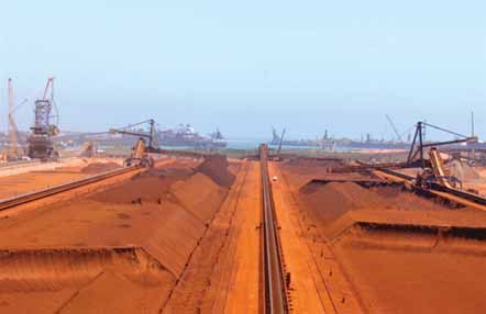
Into the Iron
In April 2011, Tucson, Arizona, USA-based Mintec Inc. announced Fortescue Metals Group, Australia’s third largest
iron ore producer after BHP Billiton and
Rio Tinto, had selected MineSight soft-ware for mine planning.
MineSight Applications’ Perth manag-er, Glenn Wylde, said at the time, “This
sale represents a significant break-through for us in the Pilbara region.
Along with the sale to BC Iron last year,
and headway at other major sites, we are
pushing hard into one of the largest grow-ing mining regions in the world.”
Previous to the Fortescue announce-ment, in December 2010, MineSight
Applications announced it had landed a
deal in Mongolia, winning a contract to
supply software for open-pit operations at
the massive Oyu Tolgoi copper project.
In November 2011, Mintec intro-duced MineSight 7.0. According to
Mintec President John Davies, “The inte-gration of the tools in our short-term
planning suite—MineSight Interactive
Planner, MineSight Haulage, MineSight
Schedule Optimizer and Material
Manager—provides a formidable tool for
rapid schedule evaluation.
“MineSight Version 7.0 removes the
limits on block model sizes,” said
Davies. “Geologists and engineers using
block models to make mine plans and
production schedules can create mod-els without constraint, using the latest
version of MineSight 3-D. They can pro-duce a more detailed block model,
while maintaining the original block
model extents.”
The latest version provides 64-bit
support for drillhole management pro-grams, MineSight Data Analyst, (MSDA)
and MineSight Torque. “We have various
multithreaded critical engines for per-formance, and the new 64-bit applica-tions will run faster and have unlimited
memory footprints,” said Davies. “Some
of our MineSight Economic Planner runs
are 70 times faster than older versions
prior to 64-bit technology.”
Davies said that for clients, the im-provements mean easier modeling and
integrated mine planning. “And we are
continuing to develop new tools and
applications that will serve clients with
underground and stratigraphic deposits.”
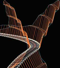 Among four new plug-in modules for Ventyx’s latest
version of MineScape is a module that allows engineers
to quickly plan mine haulage roads and dragline routes.
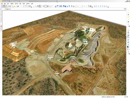
New Name, New Version, New Features
The latest release of enterprise software
provider Ventyx’s MineScape product
suite, Version 5.2, includes multi-lan-guage support, greater performance
improvements to increase mine-planning
speed, new design features, and other
enhancements that further increase
usability, according to the suite’s devel-oper Mincom, which was acquired by
ABB in mid-2011 and merged with
ABB’s Network Control business group
under the Ventyx name.
Additionally, MineScape 5.2 intro-duces four new plug-ins:
• Haulage Roads, which guides engi-neers through the process of planning
mine-haulage roads and dragline paths.
Complex road designs can be complet-ed in minutes, according to Ventyx,
allowing engineers to compare multiple
design concepts, including horizontal
and vertical alignment and cut-and-fill volumes.
• Ring Design, which provides an inter-active, three-dimensional Computer
Aided Design (3-D CAD) environment
from which users can perform under -ground ring drill mine design and blast-ing. Visualization and design tools en-able users to take into consideration
both planned and prior mining at differ-ent levels, and generate complex under-ground mine designs within minutes.
• Underground Survey is specifically
designed for underground surveying,
which provides storage, management
and processing of large quantities of
survey-point data, as well as standard
survey and orthogonal measurements.
The 3-D CAD visualization tools enable
users to view any selection of survey
points and measurements stored in the
database, with the capability of draw-ing schematic drives for which ortho-gonal measurements exist.
• Schedule 3-D is an extension of the
MineScape Schedule tool, which pro-vides 3-D visualization of mining
blocks. Typically used for underground
mine scheduling, Schedule 3-D en-ables users to create, visualize and
select designed underground stoping
blocks, giving engineers a clear under-standing of the scheduling steps, thus
stream-lining the process.
Other improvements include the abil-ity to integrate third-party plug-ins, new
CAD dimension and measuring tools,
improvements in plotting capabilities to
make design time faster and more intu-itive, and support for Microsoft Windows
XP/7 64-bit operating systems.