A laser scanning robot similar to the one shown here was recently used to scan an underground silver mine in
Mexico, allowing the mine operator to replace existing mine drawings with up-to-date dimensional information.
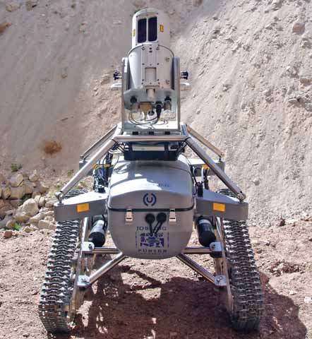
Laser Scanning Robot Maps Silver Mine in Three Days
The survey, employing a unique laserscanning robot, also enabled Arian Silver to replace existing mine drawings with geometrically accurate plans and support operational design and planning as the second phase of drilling commences. 3D Laser Scanning claims that the robot, known as 3D-R1, combines state of the art laser scanning equipment with wireless communications and advanced robotic technology to offer significant improvement in the speed of data capture, the range and coverage of measurements and the safety of survey personnel.
The data capture element of the project was completed in just over three days. Covering 2.2 km of underground drives, stopes and access ramps, 3D-R1 conducted more than 80 scans per day collecting an estimated 99.36 million individual data points—more than 5 gigabytes of data. The raw data was then processed to create a comprehensive 3-D plan of the underground mining operation.
The data was delivered to the client in a variety of formats compatible with leading mine development software packages including Datamine, MicroMine and Vulcan, and was in use at the client site in less than a month. According to the company, the resulting data corresponded exactly with existing topographic aerial photographs and contour maps of the mine site already held in MicroMine.
Owain Morton, Arian’s mining engineer said, “I estimate that you could employ a mine surveyor for a complete year and not get the same amount of data and accuracy of plans as delivered by the robot.”
The 3D-R1 remote operated survey vehicle was developed in partnership with Jobling Purser RSV LLP and was originally designed for use in underground mining operations to reduce the risk to the survey operator and to improve operating efficiencies. It was developed from a prototype vehicle first designed by James Jobling- Purser as part of an undergraduate project at the Camborne School of Mines part of the University of Exeter.
3D-R1 is designed to be compatible with the Riegl LMS-Z series of laser scanners. These units comprise a high performance long-range 3-D laser scanner, software and an integrated high-resolution digital camera.