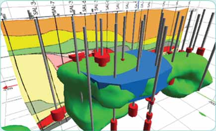
Geophysical Software Gets New Name, Features


Encom has released the latest version of its geophysical interpretation package, Encom PA 7.0, which incorporates a change in name and feature packaging and a free viewer. Encom PA, previously called Profile Analyst, now supports drag and drop of 2-D and 3-D objects into 2-D maps and 3-D views using automatic interpretation of industry standard data formats and model objects. The range of acceptable formats is large and covers ground and airborne geophysical surveys, drillhole geology and geochemistry, mine models, geophysical models, remote sensing and GIS. Encom also has configured product packaging into three options: a fully featured professional version called PA Professional, a fully functional processing and visualization system named PA Explorer and a free viewer called PA Viewer. PA Explorer includes all visualization modes for 1-D and 2-D mapping, 2-D sections and 3-D data, including a 3-D fly-through generator. It also includes a range of specialized filter modules, object builders and processing toolkits. PA Professional extends the capabilities with a full 3-D object construction and editing environment, 3-D voxel toolkit and advanced FFT GeoFilter module. PA Viewer is freely distributable to colleagues and third parties and provides tools necessary to visualize, zoom, pan and print any PA Professional or PA Explorer project session file.

www.encom.com.au
As featured in Womp 08 Vol 1 - www.womp-int.com