Perhaps the best indication of how widely
a specific technology has been accepted
by an industry is the amount of “wow”
factor a new announcement must pack in
order to make people stop and think
about where that technology has come
from, and where it’s going.
That
appears to be
the case with
GPS-assisted
location and
guidance of
mining equipment,
a technology
sector
that has had
its moments
in the trade
press as various
projects
and products
were announced,
often with
great fanfare,
and then receded
into the
background
after either
being gradually
assimilated
into general
industry practices—
or quietly
moved to
the back burner by their sponsors.
Starting in the mid-1990s with
Caterpillar’s initial development of its
Computer Aided Earthmoving System
(CAES) and Komatsu’s purchase of a
controlling interest in Modular Mining
Systems, which at the time was focused
on refining its system for real-time
haulage fleet dispatching, the industry
has seen—and widely adopted—a steady
progression of technological advances
that have improved the accuracy, reliability
and scope of GPS location and guidance.
It’s no longer a novelty during mine
visits to encounter a truck, shovel, drill or
dragline equipped with some type of GPS
location/guidance system from Caterpillar,
Komatsu, Wenco, Leica Geosystems
or Novariant, for example, and
recent developments have generally been
evolutionary rather than revolutionary.
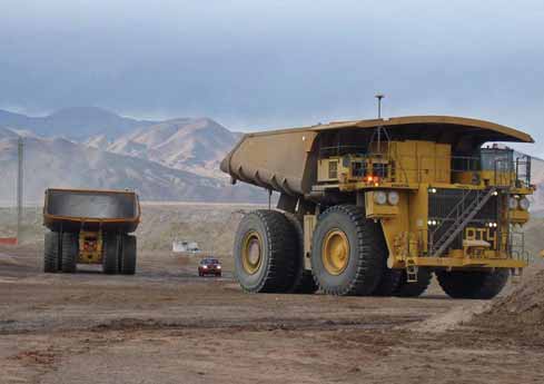 From the large to the small: High-precision GPS technology
plays a role in both these Komatsu 930E-4
From the large to the small: High-precision GPS technology
plays a role in both these Komatsu 930E-4
haul trucks, configured for
autonomous operation at Rio Tinto’s Australian iron ore mines; and in
MineMapper,
a system that combines laser scanning with
GPS location that can be mounted on almost any vehicle to
generate highly accurate
terrain measurements while on the move.
In mid-January, Rio Tinto’s Chief
Executive, Tom Albanese, unveiled his
company’s vision of the mine of the future,
describing the initiative as “part of
Rio Tinto’s drive to maintain its position as
Australia's
leading iron ore
producer. ”
According to
Albanese, Rio
Tinto intends to
be the leader in
integrated and
automated
mining and
transport in the
Pilbara iron ore
region, leading
to greater efficiency,
lower
production
costs and more
attractive working
conditions
that will help it
to recruit and
retain staff in
the highly competitive
labor
market.
Albanese
said major components
of the
autonomous mining plan will be commissioned
in Rio Tinto Iron Ore operations in
2008 and 2009, including establishing a
remote operations center (ROC) to manage
operations in the Pilbara mines. The ROC
will allow operators overseeing the company’s
mines and process plant facilities to be
physically located in Perth.
Albanese said, “Rio Tinto is changing
the face of mining. We have at least a
three-year start on the rest of the industry,
which has focused on discrete technologies
rather than modernizing the
whole mine-to-port operation. We're aiming to be the global leaders in fully integrated,
automated operations. It will
allow for more efficient operations and
directly confront the escalating costs
associated with basing employees at
remote sites, giving us a competitive
advantage as an employer along the way.”
Other mining executives may find
Albanese’s statement debatable, but the
company has introduced a number of key
technologies on a staged basis to support
this scenario, beginning in 2006 with the
development of autonomous drilling rigs
for the Pilbara. In early 2007, Rio Tinto
established and funded the Rio Tinto
Center for Mine Automation in partnership
with The University of Sydney. Under this
partnership Rio Tinto secured exclusive
access to robotics experts to address its
mine of the future opportunities.
During a media tour of the company’s
Pilbara operations in January, Greg
Lilleyman, general manager East Pilbara
operations–iron ore, noted that Rio Tinto
had created a technology test hub at its
West Angelas mine for centralized testing
of autonomous trucks, drills, other equipment
and remote operations and planning
systems.
Trials will include the Komatsu autonomous
haul trucks and a range of other
advanced remote control and autonomous
technologies. Experience gained there,
according to the company, will allow for
further deployments in the Pilbara in
2010 and will also have application at
other Rio Tinto mining operations.
Komatsu America’s manufacturing
facility in Peoria, Illinois, USA, will produce
the 320-ton-capacity 930E-4 electric
drive trucks equipped with the
FrontRunner Autonomous Haulage System,
a navigation system developed by
parent company Komatsu Ltd. and integrated
by Modular Mining Systems Inc.
Although Komatsu America did not disclose
details of the truck order from Rio
Tinto, it is thought to involve initial delivery
of five or six 930E-4s during 2008.
Komatsu previously supplied a fleet of
FrontRunner-equipped 930E-4s to Codelco
in Chile.
Rio Tinto said the automated haulage
system will be commissioned before the
end of 2008 and is expected to be more
widely deployed by 2010. According to
Albanese, the implementation will likely
occur first at the company’s newer mines
constructed as part of its current expansion
plans.
The company said studies are also
being finalized on the application of
autonomous train operations technology
in a heavy haul capacity. Mainline trials
conducted with the Western Australia
Office of Rail Safety have progressed well
and a decision on the next stage of the
project is expected in mid-2008.
Automated rail management is the first
major operation scheduled to be run from
the ROC.
The East Pilbara ROC will be built for
Rio Tinto near Perth’s domestic airport.
When completed in 2009, the facility
will be staffed by more than 300 employees
who will work with Pilbara-based personnel
to manage and operate key assets
and processes, including all mines, processing
plants, the rail network, ports
and power plants. Operational planning
and scheduling functions will also be
based in the ROC.
Remote operation of Rio Tinto’s mines
and plant in the Pilbara has already been
successfully trialed, and the company
recently began operating the processing
plants for its West Angelas and Hope
Downs mines from a site in Perth.
One of Many
GPS-assisted machine location and guidance
will be just one of many technologies
implemented in Rio Tinto’s ambitious
autonomous mining scenario, but it
will be an important element and its
inclusion illustrates the high degree of
sophistication achieved in this area.
Although only a handful of mining companies
have the money, technical
resources and property assets that could
justify autonomous mining of the scope
envisaged by Rio Tinto’s plans, the range
of products available in this sector allows
smaller producers to take advantage of
GPS services to reduce mining costs,
increase productivity and improve both
human and machine safety.
Undoubtedly the Rio Tinto announcement
will draw renewed attention to the
current state of GPS technology as it
applies to mine operations, but as far as
several key suppliers are concerned,
buyer interest is already at a high level.
For example, Novariant, a Fremont,
California-based supplier of precision
positioning systems, recorded first-half
2007 revenues more than 50% higher
than the same period a year earlier, and
now has systems installed at sites in
Arizona (Freeport MacMoRan’s Morenci
mine), Utah (Rio Tinto’s Bingham Canyon
mine), Australia (KCGM), and South
America (Los Pelambres and Los
Bronces—including the recently approved
Los Bronces Development Project expansion
which is expected to make the
Chilean copper mine one of the largest
producers in the world).
Kurt Zimmerman, technology manager
for Novariant’s mining group, said that
Novariant is focusing on optimizing the
performance of its Terralite XPS positioning
system in complex or oddly shaped
pits, particularly with regard to increased
pit depth and “shadowed” corners of the
mine. “Customers are asking us to
enhance the effectiveness of our system
to meet the specific conditions of their
operations, mainly for high-precision
applications such as drills, dozers and
shovels. But we’re also seeing customer
interest expanding beyond these typical
applications to other types of mine
equipment that traditionally haven’t
required high precision, such as haul
trucks. Basically, when the availability of
the equipment requiring high-precision
location improves, it often opens up other
[GPS-related] possibilities for improving
mine operations.”
Novariant’s Terralite XPS System uses
a network of ground-based transmitter
stations to broadcast a proprietary XPS
signal to one or more mobile GPS+XPS
receivers, allowing operators of GPSenabled
machines to receive continuous
real-time positioning information in locations
and under conditions in which conventional
GPS information may be
unavailable.
Hexagon, the Swedish parent company
of Leica Geosystems, advanced its
market presence by acquiring Jigsaw
Technologies last year. Jigsaw produces
fleet management software, with sales
estimated at $9 million for 2007. Leica
Geosystems’ products have sold well in
South America—last year, for example,
Leica Geosystems Mining supplied seven
precision navigation and monitoring drill
systems to Newmont’s Minera Yanacocha
mine in Peru—as well as in Australia and
Southeast Asia, and Hexagon bought
Tucson, Arizona-based Jigsaw to bolster
its sales in North America. At the time of
the acquisition announcement in mid-
2007, Hexagon estimated the overall
market for machine control was growing
at a rate of 25% annually, with global
sales exceeding $850 million, driven mainly by demand in the mining, construction
and agriculture industries.
The role of precision GPS location and
guidance in autonomous mining is clearly
illustrated in a current project conducted
by Freeport McMoRan’s Mining
Technology Group in North America. The
project, known as Ardvarc and involving
Flanders Electric for their control system
expertise, is aimed at developing a fully
autonomous blasthole drill. Ardvarc is a
tracked rotary rig that can tram, set up,
sink a hole with high precision and move
on to the next position while keeping
track of what’s happening in its proximity,
all without need of human guidance.
Ardvarc uses both orbital GPS and
ground-based location and guidance systems
such as Novariant’s for highly accurate
positioning, but Steve Williamson of
the technology group stressed that the
success of projects such as Ardvarc
depends on integration of many different
systems, including wireless communications,
navigation, proximity sensing, day
and night vision, machine health and
diagnostics, and data collection and
reporting, among others.
The control system for the drill was
assembled using commercial, off-theshelf
components, said Williamson, who
cautioned that even though technology is
now readily available to accomplish projects
such as Ardvarc, the employees who
will use or work around these machines,
and even the personnel who have to maintain
them, may not initially fully understand
or even accept the concepts behind
the application. “This is a process that
has to extend from the general managers
down to the workers in the mine,” said
Williamson. “People need to buy into a
technology—to take ownership of it—
before it can be considered a success.”
The Ardvarc drill was being tested in
December with an operator onboard simply
as a safety backup, Williamson
explained, but the company expects to
move forward with tests involving fully
autonomous operation in 2008. Once
proven, the system will be applied to other
rigs—all Atlas Copco Model 271 Pit
Vipers—at the Morenci and Safford mines.
The project also has drawn a high level of
interest from the company’s Grasberg
operation in Indonesia, he noted.
Building from Basic to Ultra
Caterpillar, which was an early entrant in
the market with its CAES, has steadily
upgraded the system’s capabilities; the
current flagship version, CAESultra, is
capable of utilizing both the GPS and
GNSS (Global Navigation Satellite
System) systems, and can also use
Novariant’s Terralite XPS positioning solution.
CAESbasic provides CAES’s onboard
computing power without a wireless link or
CAESultra’s suite of office software.
CAESbasic-equipped machines can be
upgraded to higher functionality by adding
a few additional hardware components.
Caterpillar estimates that users can
raise productivity in specific areas by an
average of 25% using CAESultra, taking
into account reduced rework requirements,
higher ore recovery rates, reduction
or elimination of surveying costs and
other factors.
The system now requires only three
onboard components: the display unit, an
“all in one” receiver/antenna, and radio.
The MS990 GNSS receiver offers better
performance than previous receivers,
according to Cat, and initializes much
faster than earlier models. Cat’s TC900C
radio is now an optional component if a
customer is using CAES version 3.1 software,
which enables mines to use an IP
radio network of their choice; they can tie in CAES-equipped machines to their
existing network by connecting the IP
radio to the onboard display through a
ruggedized Ethernet port on the back of
the display.
Another function enabled by version
3.1 software is peer-to-peer communications,
which allows multiple machines to
“see” each other in real time, a valuable
feature when working at night, during
inclement weather or in the vicinity of
blind spots.
Cat also offers the Aquila Drill
Monitoring system, in three versions:
Basic is primarily reserved for OEM sales
to drill manufacturers and can capture
hole depth, penetration rate and rotary
speed information. Production is the normal
base system for customer purchase.
It builds on Basic by adding wireless communication
and increased reporting capabilities.
It displays and records six drill
variables, including depth and penetration
rate, rotary speed, pulldown pressure,
bailing air pressure and rotary torque. The
third version, Strata, adds the ability to
associate a blastability index to each hole
drilled. This feature, when integrated with
local geological information, helps to
reduce the use of premium grade explosives
to only those areas that warrant the
added expense.
Cat says the Aquila GPS guidance
option provides the ability to locate the
drill bit within three dimensions with
accuracy to ±10 cm of the known location.
The system automatically adjusts the hole
depths based on the zed elevation, measured
from the tracks of the drill, ensuring
that the rig is drilling to the designed target
elevation. The system is applicable to
both vertical and incline drill rigs.
Back to the Future?
GPS technology, which started out
“small” in mining with the introduction
of backpack-transportable surveying
units in the early 1990s, has executed
almost a complete development cycle as
it has filtered back down into smaller
equipment categories after reaching the
top, so to speak, with its inclusion on the
industry’s largest equipment. In addition
to fitting its largest mining trucks for GPS
assisted autonomous mining, Komatsu,
for example, now equips its constructionclass
vehicles with Komtrax, a satelliteassisted
machine status and location system
that employs GPS technology to
keep track of a machine’s location.
Elsewhere, U.K.-based 3D Laser
Mapping announced that it has developed
a mining version of its StreetMapper system.
MineMapper uses mobile laser scanning
technology combined with high precision
positioning systems to capture
accurate and detailed measurements
while on the move.
MineMapper comprises a set of vehicle-
mounted laser scanning units together
with an onboard positioning system
that uses GPS information and inertial
navigation. Each scanner transmits an
optical pulse from a known position and
at a known direction and angle and
records the time taken for the beam to be
bounced back to the receiving unit. The
speed of light is then used to calculate
the exact position of the feature from the
laser unit. The system is claimed to be
capable of capturing up to 40,000 measurements
per second with a typical accuracy
of 3- to 5-cm, and can be deployed
on a range of vehicles to suit all terrains.
When combined with 3D Laser Mapping’s
SiteMonitor software it can create detailed
3D models of a mining operation
for depletion surveys, slope stability
models, stockpile measurements and terrain
map updates.
As featured in Womp 08 Vol 1 - www.womp-int.com