Drilling is the predominant cost factor in exploration spending, accounting for almost half the money
spent by companies to discover and delineate a deposit, according to a recent Canadian survey.
Exploration 2007: More Efficient, But More Expensive
Spending is at an all-time high, technology is rapidly advancing—and
costs are rising
By Russell A. Carter, Managing Editor
According to Metals Economics Group’s (MEG) latest edition of Corporate Exploration Strategies, global spending for exploration reached $7.5 billion in 2006—the fourth consecutive annual increase since the bottom of the cycle in 2002 and a record for global nonferrous exploration.
MEG’s 2006 analysis included 1,624 companies’ exploration budgets (using a $100,000 cutoff) for a total of $7.13 billion, accounting for an estimated 95% of global nonferrous exploration expenditures. MEG then added an additional $0.37 billion to that figure to represent exploration spending by companies that were active but for which budget figures were unobtainable.
Not only are budgets rising, but the overall makeup of exploration spending throughout the industry is changing. According to MEG’s survey, exploration spending by junior companies has increased by 600% since 2002, accounting for most of the overall increase in exploration allocations by all companies from 2002 to 2006. In fact, the spurt in junior exploration spending that began in this time frame lifted the juniors’ combined budgets above those of major companies for the first time in 2004— although by only $7 million—and juniors accounted for more than half of 2006’s worldwide exploration budget total.
On a regional basis, MEG reported that Latin America continued to be the most popular destination for exploration, a position it has maintained for more than a decade, and even increased its lead for the third consecutive year over Canada. Interest in new, under-explored areas (what MEG calls its rest-of-world region, comprising Europe, the former Soviet Union, Asia, and the Middle East) continued to rise in 2006, led by substantial increases in Russia, China and Mongolia, and lifting the region into third place ahead of Africa. Australia held onto fifth place, while the United States and the Pacific/Southeast Asia regions remained in sixth and seventh place, respectively.
Judging by the recent annual spending figures, there’s certainly plenty of capital available to fund exploration these days—but is the increased spending resulting in a higher level of exploration activity, or does it just represent the accelerating cost of conducting any type of exploration program?
The MEG survey concludes that increased demand for services such as drilling and assaying, and rising costs for everything from fuel to geoscientists, have significantly increased the costs of exploration in the current cycle beyond overall inflation. While there is anecdotal evidence of a substantial rise in exploration activity in recent years, higher costs make it unlikely that the growth in activity has paralleled the substantial increase in exploration budgets over the past few years.
Industry consolidation and its associated “search for synergies” haven’t helped, either. The report concludes that, although consolidation’s effect on exploration appears to vary depending on whether the global exploration effort is increasing or decreasing, it has had a negative effect on exploration in every year over the past decade, regardless of where the industry is in the exploration cycle.
Drilling is Dominant
What are the billions of exploration
dollars being spent on? The most recent Canadian Survey of Mineral Exploration,
Deposit Appraisal and Mine Complex Development Expenditures, compiled annually
by officials from Canadian provincial/territorial departments responsible for
mineral exploration, and from Natural Resources Canada, provides a broad indication.
According to the 2006 survey, a detailed cost breakdown for each of the exploration
and deposit appraisal work phases continues to show that drilling (surface and
underground) is the most important cost component in the discovery and delineation
of a mineral deposit. In 2005, for example, surface and underground drilling
(diamond drilling and other types of drilling) at Canadian sites accounted for
47% ($522 million) of the $1.12 billion spent on the exploration work phase.
Surface drilling represented the vast majority of exploration-related drilling activity covered by the survey. In fact, 92% of the $522 million spent in Canada during the survey period for exploration-phase drilling was allotted to surface drilling projects. However, the report shows that geoscientific surveys (geology, geochemistry and geophysics) also represent a very important cost component in that work phase. In 2005, 32% ($352 million) of all explorationphase spending was recorded under the geoscientific surveys cost category.
Overall, exploration technology appears to be following the trends that are shaping the mining industry’s current and future practices, some of which include a growing dependence on sensing technology and computerization/automation to compensate for increased worker safety concerns and a smaller, generally less experienced workforce; a gradual shift from surface to underground operations; and better tools for managing the data collected by both traditional and newly emerging exploration methods.
Exploration data collection, management and presentation solutions, in particular, are receiving a lot of attention. As reported in May (E&MJ, “GeoSoft Forms Global Solutions Group,” p. 85), Toronto, Ontario-based Geosoft (www.geosoft.com) announced that it has established a Global Solutions Group that will specialize in helping mining and exploration companies handle their quickly expanding exploration data assets. Geosoft also said it has strengthened its relationship with ESRI, a geographic information systems (GIS) software developer, through a new collaboration to deliver integrated software and data management solutions for mining and geosciences.
Geosoft said Teck Cominco entered into an agreement that will enable the Canadian zinc and coal producer to deploy a scalable, integrated solution comprising Geosoft’s data server and application software, along with ESRI’s ArcGIS and acQuire technology, across Teck Cominco’s global operations. The agreement, said Geosoft, establishes an interoperable software platform capable of addressing Teck Cominco’s growing exploration data management needs.
Gemcom (www.gemcomsoftware.com) is marketing its GEMS Advanced Exploration Configuration, a fully integrated data management, analysis and 3D geological modeling software system that offers advanced 3D solid and surface modeling operations, as well as base volumetric calculations and visualization. The package provides standard tools for entering, digitizing, importing, storing, validating, manipulating, drillhole compositing, extracting, filtering and reporting spatial data, as well as options for analyzing data using histograms, scattergrams, classical statistics, log and probability graphs. It allows regression analysis or fitting of models to semi-variograms as needed.
In April, Ontario-based fsc Limited (www.4site.com) announced the availability of 4Site Exploration Project Management, an enterprise asset management program applicable to exploration projects. Details of the product were unavailable as E&MJ went to press, but a company press statement said, “Use of 4Site allows easy and cost effective transition from exploration to capital construction and then to full production within the same system.”
Software solutions for data interpretation and modeling continue to evolve, as well. Australia’s Encom (www.encom. com.au), a developer of specialized software for mineral exploration, announced that it has added significant advances to its flagship magnetic and gravity interpretation product, ModelVision Pro, with the release of version 8.0.
According to Encom, ModelVision Pro can simulate, visualize, model and invert data from surveys like the Falcon airborne gravity gradiometer, Bell Geospace full tensor gravity gradiometer, Squid full tensor magnetometer, horizontal gradient magnetometers and ground surveys.
The latest release contains a new method for quick interactive overburden mapping that allows the user to dynamically switch between total magnetic intensity and first vertical derivative methods for precise location of depth and geological boundaries at the basement surface. Unlike pure automated methods, Encom says this user-guided geological interpretation procedure allows the geophysicist to produce useful geological information as well as precision depth estimates. The first vertical derivate option has also been implemented in the advanced 3D inversion engine.
ArcGIS and MapInfo GIS geological maps can be combined with digital terrain grids and converted directly to compressed, faceted 3D geological models for use in advanced exploration problems. These models can be applied to multiple problems such as variable terrain density corrections for airborne gravity gradiometer surveys, geological constraints for UBC GRAV3D and MAG3D inversions, target detection analysis in difficult terrains, survey simulation in complex environments and bulk physical property analysis.
ModelVision Pro functions have been extended in areas such as UBC model mesh building, file format support, grid manipulation utilities and live integration with the new Encom PA Explorer 3D visualization environment.
Suppliers Seek Market Share
Equipment manufacturers are highly cognizant
of the money being spent for
exploration, to the point of adding new,
separate exploration-oriented divisions to
their existing organizational structures.
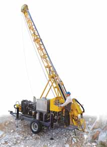
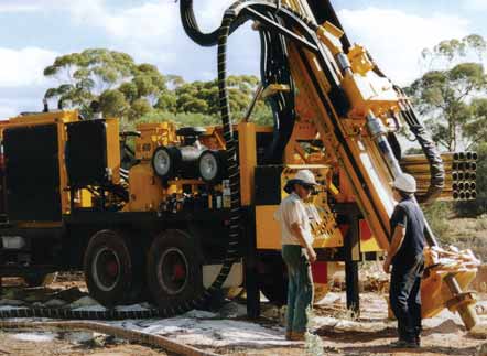
Sandvik products for exploration now cover a spectrum extending from drillcuttings sampling systems such as the Rotaport cone splitter and the RC involution cyclone; to compact portable drill rigs such as the KL 10, mid-sized rigs such as the UDR 250D; and large, truckmounted rigs that include the UDR 1200 and KL 1500. Sandvik’s arch-rival, Atlas Copco, is not conceding any exploration market segment to competitors, with its Atlas Copco Exploration Products group incorporating the assets gained from mergers and acquisitions that have included Christensen Products (core drilling rigs), Hobic (core bits and other core drilling tools), Craelius (exploration drill rigs, diamond coring and noncoring bits), and Diamec (underground drill rigs). In February 2007, Atlas Copco changed the name of its Craelius division to Geotechnical Drilling and Exploration, to indicate the specific markets on which its efforts are focused.
The latest addition to the Christensen drill-rig range, the CS10, was introduced in 2006 and is a strong contender in the light rig segment. Rated at more than 1,000 m vertical depth capability in B size, 760 m N size, 460 m H size and 300 m P size wireline coring, the CS10 is designed for reduced equipment weight without compromising productivity or performance. Mounted on a singleaxle trailer, the rig can be disassembled in modules for helicopter transportation.
The most recent Diamec model, the U4, also launched in 2006, is the successor to the older Diamec 252, Diamec 262 and Boyles B-10 units. It offers a design that incorporates fewer components for reduced maintenance costs. The boom, derived from experience gained with the larger Diamec U6, enables easy and fast positioning. A telescopic hydraulic cylinder replaces chains or steel ropes on the feed, reducing wear and allowing smoother feeding force to enhance penetration rate and diamond bit life. The U4, available with either a manual control system or APC (Automatic Performance Control), is able to handle A, B and N sizes and offers a depth capacity of more than 500 m with A size.
Boart Longyear’s most recent exploration drilling products include variable wall coring rod, a fast descent core barrel, and a semi-automated rod handler.
The variable-wall rod is claimed to offer up to 30% less weight than conventional coring rod, along with increased inner tube clearance, improved performance in deviated holes, and proven RQ threads for higher load capacity.
The fast descent core barrel uses a direct fluid porting design that allows the inner tube to easily pass through fluid, while the device’s improved Link Latch technology enables smooth inner tube travel without contacting the drill rod. The result is a tube descent rate up to 30% faster than previous units, according to the company.
The semi-automated rod handler is compatible with all BL LM/LMA underground diamond drills, and features ergonomic design to permit safe rod handling with reduced risk of worker hand and back injuries. It is equipped with a non-intrusive laser guard system and can handle drill rods and core barrels up to and including HQ size.
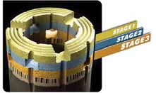
This design, says BL, makes the Stage3 more structurally sound than the standard Alpha or Extended Crown option with 9.5 and 12.7 mm waterways, respectively. The superior crown strength is reinforced by staggering each consecutive stage of windows. The window design is also efficient, allowing for faster flushing of cuttings and higher penetration rates. The longer crown height of the Stage3 adds stabilization to the bit resulting in less deviation, resulting in longer reamer life.
Surveying and Sampling
Reflex (www.reflex.se) launched
its new EZ-Trac borehole survey tool earlier this year, touting it as a significant
timesaver for drill crews. The instrument, housed in a pressure barrel and needing
only minor assembly for usage, enables survey results to be automatically calculated
and displayed directly after download, eliminating the risk of human mistakes.
Reflex points out that the EZ-Trac is capable of performing single-shot, multishot
and orientation surveys, so that a drill crew only has to be trained once to
cover all surveying needs. Device control is through either a Recon Pocket PC
device or by using the EZ-Com, a dedicated control unit developed by Reflex.
The Recon Pocket PC is waterproof, capable of accurate operation in both high
and low temperature environments, and resistant to drop and vibration. The Reflex
software running on the Recon device handles both surveying and data presentation
with survey results, including local and regional coordinates, displayed in
tabular and graphical formats. The application also offers a number of advanced
functions, such as quality verification, merge, export and recovery.
Reflex says the EZ-Trac performs surveys in all directions, including vertical, with high accuracy. Using modern magnetic and gravimetric sensors, the EZ-Trac provides independent results for every survey station—so azimuth and dip errors do not build up over distance, as with gyros and other instruments based on relative measurements.
Innov-X’s design uses an x-ray tube in a compact assembly that comes in two versions: a removable PDA model or a model with totally sealed internal electronics. Both are designed for use in tough field applications, featuring dual front/back color displays that are easy to read in any lighting conditions, including direct sunlight. Other advantages, according to the company, are reduced regulatory worries— the units are easy to transport with minimal travel restrictions—and freedom from liability of isotope control, improper usage, theft and disposal problems.
The systems are configured with a standard package of up to 25 elements including precious metals.
The Home Front
In the current tight labor market, where
senior exploration personnel are scarce
and less experienced workers can sometimes
command six-figure salaries, companies
are acutely aware that keeping
qualified field workers onboard is critical
to project success. To attract and retain
them, employers must offer comfortable
living accommodations and other perks.
Texas, USA-based Porta-Kamp International (www.portakamp.com), manufacturer of workforce housing products for remote locations, says it is helping to meet this demand with a variety of additional products and services designed to make camp housing comfortable, yet cost-effective.
For frigid locations, Porta-Kamp camp buildings feature R-40 insulation on the roofs and floors. Windows are argon-filled fiberglass. Once the structures are in place at the camp, they can be connected by enclosed hallways that eliminate worker exposure to outside conditions. To enhance the interiors of the camp structures, Porta- Kamp is offering a range of amenities called Crew Comfort Options. The list includes extras such as flat-screen TVs, wireless Internet access, installed sound systems, personal refrigerators and other features that contribute to a home-like environment for employees at remote locations.
Weatherhaven (www.weatherhaven.com) designs shelters for exploration camps located at high altitudes and latitudes as well as in tropical or semi-tropical environments. Its insulated Series 4 shelters provide a comfortable living environment in high wind, low temperature, and heavy snow conditions. Series 4 shelters can be linked to a central corridor so that occupants do not have to go outside to reach other areas of the camp. Shelters are covered in a high-tech vinyl material that has high tear strength, fire retardant and resistant to mildew and ultraviolet radiation. Series 8 shelters can be configured with a thermal cap that covers the top half of the shelter to reduce heat. Also available are various air-conditioning and cooling systems that can be integrated into the Series 4 or Series 8, along with insect mesh, awnings and side ventilation openings to circulate air into the buildings for cooling.
Weatherhaven also manufactures two expandable container shelters—the Mobile Expandable Container Configuration (MECC) and the Expandable Remote-Site Accommodation (ERSA). Both shelters meet ISO shipping standards so they can be shipped anywhere in the world by air, rail, road, and sea. These ISO container shelters, according to the company, are ideal for applications that require infrastructure with heavy-duty mechanical and electrical systems, such as washhouses, workshops, laundry facilities and kitchens. The systems are pre-installed and mounted in the center core of the shelters for quick commissioning after arrival on site.
Camp logistics, typically a time-intensive, hands-on task, is joining other traditional camp management-related functions on the Internet. For instance, CampControl, a Web-based system for the management of exploration logistics, was originally developed for internal use by Nugget Expediting, an exploration expediting company in British Columbia, and is now available for use worldwide on a subscription basis. Under this system, all logistics requests, and actions taken as a result of each request, are recorded in a central database, providing what the company claims is unprecedented management control over the logistics function.
CampControl is a modular system in which an account manager can create and remove users as the company’s needs change; it is even possible to place the system into hibernation mode during the off season to save on subscription costs. Exploration companies can choose whether to carry out expediting functions themselves, or to contract the responsibility to professional expediters. In the latter case, all that is required is the creation, by the account manager, of a user identity and password for the professional expediter. Subscription fees range from about C$400 per month for a small account, to C$2,500 per month for a very large operation.