Benefits of Using GPS Guidance on Excavators and Shovels
By Chris Seymour, Automated Positioning Systems
 In order to be an effective production tool, a GPS-based bucket position system must provide information about the position of the bucket that not only is accurate,
but must arrive rapidly enough to allow the operator to use the information while production digging.
TGPS-based control and guidance systems
for mining and earthmoving equipment
have been in use for a number of years.
These systems have proven themselves in
rugged applications as a way of cutting
costs, increasing accuracy, reducing contamination
and improving site safety.
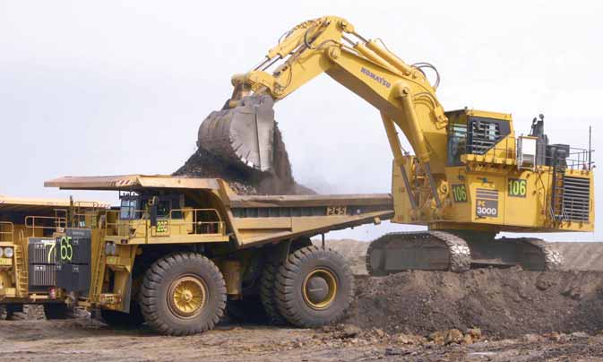
High-precision GPS-based guidance
systems on mining excavators and shovels
offer a number of key benefits to mine
operators. These include:
• Accurate selective mining of mineralized
horizons.
• Accurately finding the low wall batter
line in coal stripping operations, thereby
reducing both over-dig and lost coal.
• Accurate representation of hazardous
areas, such as loaded blast areas or areas
underlain by old underground workings.
•More even benches, reducing truck
cycle times as well as wear and tear on
trucks. Such benches require less dozer
and grader time.
• More accurately cut ramps, again improving
tire life and truck cycle times.
• Selective mining of coal, ensuring high
value seams are fully and cleanly recovered.
• Automatic generation of as-built plans.
• Less need for surveyors in the field and
far fewer people on the ground around
heavy machinery.
Logical Choice
Introducing GPS-based excavator/
shovel guidance systems can be regarded
as a logical progression for many mines,
most of which now use GPS for surveying.
A single surveyor can accomplish in a few
hours what once took a team of people
days of tedious field and office work.
GPS guidance systems are increasingly
being used directly on mining machinery—
most notably dozers. Even the most basic
GPS guidance systems allow the operator
to complete complex earthmoving designs
without the need for field staking, while
more advanced systems allow for accurate
real time productivity monitoring and the
automatic generation of “as-builts” in the
form of Digital Terrain Maps (DTMs).
In addition to dozers, GPS is now also
being applied to other mining equipment
including drills, trucks, graders, loaders,
and dredges. The use of high precision
GPS to determine the position of the bucket
teeth of shovels and excavators is one of
the “final frontiers”—perhaps surprising,
given the fact that there are so many benefits
in GPS-based guidance for what is
the primary loading tool for most mines.
Most people would be familiar with
the U.S.-based Navstar GPS network,
which supplies signals to the great majority
of GPS receivers, from basic consumer-
level units to the most sophisticated
military and industrial systems. The
Navstar system maintains at least 24
satellites. To achieve the required levels of accuracy, GPS-based guidance systems
need to be able to receive a signal
from at least five satellites to achieve
what is known as “lock.” However, due to
the orbits of the Navstar satellites, at various
times in the day there will be insufficient
satellites visible to achieve lock
and the signal will drop out. This problem
is exacerbated in deep-pit applications,
where mine walls limit the amount of sky
that is visible.
Dropouts can range from a few minutes to several hours during the course of
a day. GPS guidance systems can somewhat overcome this problem by also tapping
into the Russian-based Glonass system, which currently has a network of 11 satellites
out of a planned constellation of 18. This gives a total of 35 satellites available,
speeding the acquisition of satellite lock and substantially reducing signal
dropout. [Ed. Note: Proprietary systems, such as Novariant’s Terralite
XPS, also can overcome satellite access problems by using a network of ground-based
transmitter stations that broadcast machine position information to compatible
GPS receivers mounted on mobile equipment.]
To achieve maximum accuracy,
a GPS antenna mounted on the machine and a base station mounted at a fixed point
are required. Any number of machines with GPS guidance systems onboard can access
the base station. Using a base station, GPS guidance systems have an accuracy
of about 1 centimeter.
Accuracy is lost in translating the positions to the
bucket, but even on large mining excavators and shovels, it is possible to achieve
accuracy within 50 mm. Since the bucket teeth are at least 250 mm long and wear
back, this level of accuracy is satisfactory. However, accuracy also depends
to some extent on how well the shovel or excavator is maintained. Slack bearings
will introduce additional errors. On smaller machines, tighter tolerances can
be obtained down to 25 mm.
Information about the position of the bucket must
not only be accurate, but must be delivered rapidly enough to allow the operator
to use the information while production digging. Latency is the time between
the bucket reaching a certain position and the representation on the screen
showing the position. To achieve satisfactorily low levels of latency, the GPS
receivers and sensors must have a rapid response, the computer must run at a
high enough speed and the software must use efficient algorithms. With GPS receivers
operating at 5 Hz, sensors running at 20 Hz and a computer running at 700 MHz,
latency is around 300 milliseconds—a satisfactory but still noticeable
lag.
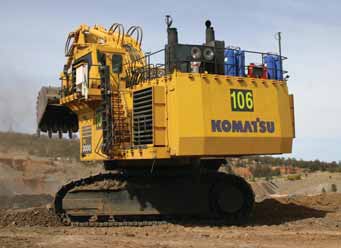
 Studies show the most effective position for excavator-mounted
GPS antennas is at the rear of the machinery house (left). To be useful to the
operator,
Studies show the most effective position for excavator-mounted
GPS antennas is at the rear of the machinery house (left). To be useful to the
operator,
the system’s display
must be simple to use, with a touch screen for easy selection and checking of
options while remaining visible under varying
ambient light conditions (right).
Communications between the mining equipment and mine management and engineering
staff is a critical element in a successful GPS-based guidance system. Radio
telemetry systems are the most effective means to transmit GPS correction signals,
to download designs to the machines and to upload as-built DTMs when the job
is finished. Many GPS survey units use VHF signals for GPS corrections. While
these radios are good for coverage, they have inadequate bandwidth to transmit
complex designs. As an alternative, UHF radios operating at 400 to 900 MHz provide
enough bandwidth to transmit designs.
Machine-mounted wireless LAN radios operating
at 2.4 GHz allow equipment to be connected into the mine’s intranet system,
or even into the Internet for remote connection. Such systems have great bandwidth,
but are limited to line-of-sight communication and distances up to 2 km. However,
some of the limitations of wireless LAN can be overcome by “meshed”
systems in which each machine is a repeater, able to pass one signal to another
machine a little farther away.
Alternatively, a dual system can be installed,
using UHF or VHF for the mission- critical GPS correction factors, with other
data cached until the LAN connection is established.
Other critical factors
in the successful application of GPS-based guidance systems on excavators and
shovels include antenna placement, rotation plane, sensor systems on the boom
and arm, and on-board computers.
Antenna placement: Experience has shown that using two GPS
antennas and two receivers, while more expensive, gives a faster and more accurate
result. The preferred locations are the back corners of the machinery house.
Rotation plane: Knowing the orientation and position of the
machinery house enables the position of the boom to be calculated. However,
it’s also essential to measure the pitch and roll of the machine to correct
the result for rotation in an angled plane.
Boom components: Tilt sensors (for hydraulic excavators and shovels)
and rotation encoders on rope drums (for rope shovels) have proven to be the
most reliable and robust solutions.
Tilt sensors are one of the most critical
factors in an effective GPS-based guidance system, with the latest developments
in nanotechnology resulting in highly accurate, robust, consistent and long-lived
units. A tilt sensor suitable for tracking mining equipment needs to have a
number of capabilities:
• Rapid response, reporting at a rate of at
least 10 times per second.
• Accuracy, performing to within 0.1° is
essential in order to achieve centimeter
level precision on mining scale equipment.
• Resistance to vibration.
• Resistance to overshoot; fluid sensors
tend to “slosh.”
• Resistance to shock loading, capable of
withstanding the high g-forces associated
with large rocks landing on the boom.
• Low maintenance.
• Easy calibration when installed in different
orientations.
• Long life; at least three years is desirable
with no drift in reported values.
• Consistent results under different temperature
and humidity regimes.
Computers used on mining equipment
must contend with difficult environmental
conditions. To be useful to
the operator, the computer must be simple
to use, with a touch screen for easy
selection and checking of options while
remaining visible under varying ambient
light conditions. Rotating hard disks
have a short life in this application, so
the use of solid-state memory is essential.
At least 2 gigabytes of non-volatile
memory is needed to hold the operating
system, system software and complex
designs.
GPS-based guidance on mining shovels
and excavators has the potential to provide
many more advantages, including:
• Ore grade tracking: The ability to determine at all
times the exact position of the bucket teeth of an excavator or shovel makes
it possible to track the volume and source of every bucket loaded into a haul
truck. If the geological model is good enough, the quality of every truckload
could be defined— allowing unprecedented quality control of material headed
for the mill.
• Advanced selective mining: It is possible to use spectral
analysis to detect highgrade ore veins in the bank. If a laser scanner or stereo
digital camera captures the data, the high-grade veins can be spatially defined
and then mined using GPS to guide the bucket.
• Data transmission: The addition of highbandwidth LAN
communications opens up the possibility of much greater data flows. For example,
it is possible to interrogate on-board maintenance health systems via the LAN.
Thus a mechanic in the workshop can determine when machines are due for maintenance
based on oil pressures, bearing temperatures and such like factors. GPS guidance
to the bucket is available and reliable, and the applications in mining many
and varied. The value of such systems is enhanced by integration into mine planning,
surveying, production reporting, maintenance management and other technical
and management information systems at the mine site. Chris Seymour is managing
director of Automated Positioning Systems (APS). Based in Brisbane, Queensland,
APS (www. apsystems.com.au) uses Topcon’s GPS+ high-precision location
system, in conjunction with additional hardware and software developed by APS
specifically developed for mining applications.
GPS CASE HISTORIES
Century Mine
The Century zinc mine, operated by Zinifex in northern Queensland has
been using high-precision GPS supplied by APS on two excavators for three
years.
Because the ore zone (itself gray) is hosted in a gray shale, visual identification
of ore and waste is difficult. Before installing a GPS system, surveyors
and geologists delineated the ore zones with spray paint, and during ore
loading, a geologist was continually present.
Now the GPS guidance system clearly shows the operator the position of
the bucket relative to the ore, and even identifies the type of ore. Since
implementing this system, there has been a significant increase in the
head grade of ore into the mill, resulting in increased output.
Century also operates GPS systems on its Bucyrus 495B shovels used for
overburden stripping. Although no selective mining is involved with these
shovels, the introduction of guidance has resulted in significantly smoother
benches and ramps, with a consequent reduction in spillage, improved cycle
times and reduced tire wear.
Thiess Contractors, Collinsville Mine
The Collinsville coal mine, owned by Xstrata Coal and operated by Thiess
Contractors, is a metallurgical and thermal surface coal producer in northern
Queensland. Overburden stripping is carried out by a dragline, dedicated
stripping dozers and excavator and truck fleets. The mine has two Liebherr
994 and two Liebherr 995 excavators, all equipped with high-precision
guidance systems from APS.
In a typical sequence with 30 m of overburden, the dozers move the top
18 m. The excavators follow, removing the remaining 12 m in three 4 m
benches. The nature of dozer stripping is such that a certain amount of
rehandling is inevitable, and it is essential that the intersection of
each excavator bench with the new spoil pile is accurately located. Over-digging
of the spoil results in unnecessary rehandling and extra costs, while
under-digging leads to possible coal loss.
Because of the geometry of the pit, every 1 m error in locating the correct
coal edge leads to 16 m3 of unnecessary rehandling per linear meter of
pit if the error is too far on the spoil side. Too far on the coal side
leads to a loss of valuable product. Before introducing GPSbased guidance,
bench limits were marked with stakes placed at 20-m intervals. Staking
is a labor intensive operation, and stakes are frequently disturbed or
destroyed in the course of operations.
Thiess carried out a rigorous survey of under- and over-excavation in
pits excavated before and after the introduction of GPS-based high-precision
guidance on the first excavator. Following the introduction of guidance
on one machine, in three pits average over-dig was reduced to one-quarter
of what it had been previously. The reduction in over-dig paid for the
systems within a few months. Thiess subsequently installed guidance systems
on three other excavators at the site. |